Assessing remotely sensed temperature humidity index as human comfort indicator relative to landuse landcover change in Abuja, Nigeria Samuel O. IgeVincent O. AjayiK. S. A. Oyekan OriginalPaper 17 June 2017 Pages: 523 - 533
Correlation analysis between the occurrence of safety accidents and land cover ratio: focused on 119 emergency activity data for Ulsan metropolitan city in South Korea Jin-Young WonJin-Dong ShinJong-Seol Lee OriginalPaper 21 June 2017 Pages: 535 - 546
Exploring 16 years changing dynamics for land use/land cover in Pearl City (Thoothukudi) with spatial technology T. Immanuvel DavidM. V. MukeshR. Premkumar OriginalPaper 04 July 2017 Pages: 547 - 554
Utilizing Spatial Big Data platform in evaluating correlations between rental housing car sharing and public transportation Junyoug ChoiJeakak Yoon OriginalPaper 11 July 2017 Pages: 555 - 564
Optimizing dispatch and home delivery services utilizing GIS in Botswana: Botswana Post case study Kealeboga K. MoreriLopang MaphaleNyalazdani Nkhwanana ReviewPaper 13 July 2017 Pages: 565 - 573
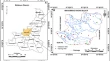
Remote sensing analysis of unknown origin of a crater in western Yemen Mohammad Reza Mansouri DaneshvarHamid Nejadsoleymani OriginalPaper 21 July 2017 Pages: 575 - 583
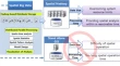
Valuing current drone CPS in terms of bi-directional bridging intensity: embracing the future of spatial information Jung-Sup Um OriginalPaper 27 July 2017 Pages: 585 - 591
Development of general purpose model for park and green space management system in South Korea Don-cherl ChoDong Bin Shin OriginalPaper 28 July 2017 Pages: 593 - 604
Evaluating land-use plan using conformance-based approach in Adama city, Ethiopia Dejene Tesema BultiNegera Dinsa Sori OriginalPaper 01 August 2017 Pages: 605 - 613
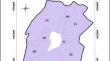
Groundwater potential mapping using analytical hierarchical process: a study on Md. Bazar Block of Birbhum District, West Bengal Sunil Saha OriginalPaper 02 August 2017 Pages: 615 - 626