Study the Effect of MRF Model on Fuzzy c Means Classifiers with Different Parameters and Distance Measures Shilpa SumanDheeraj KumarAnil Kumar Research Article 28 February 2022 Pages: 1177 - 1189
GIS-Based Water Budget Estimation of the Kizilirmak River Basin using GLDAS-2.1 Noah and CLSM Models and Remote Sensing Observations Sayed Ishaq DeliryEmrah PekkanUğur Avdan Research Article 28 February 2022 Pages: 1191 - 1209
Fuzzy Logic Approach Based on Geomatics and Remote Sensing for Siting a Petroleum Warehouse in the Metropolitan Area of Baghdad Amjed Naser Mohsin Al-Hameedawi Research Article 04 March 2022 Pages: 1211 - 1225
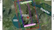
Improved Cartosat-1 Based DEM for Flood Inundation Modeling in the Delta Region of Mahanadi River Basin, India Abhishek PatelPrachi Pratyasha JenaChandranath Chatterjee Research Article 11 March 2022 Pages: 1227 - 1241
Extraction of Road Centrelines and Edge Lines from High-Resolution Satellite Imagery using Density-Oriented Fuzzy C-Means and Mathematical Morphology Mahmoud Salah Research Article 12 March 2022 Pages: 1243 - 1255
A Comparison of Discrete and Continuous Metrics for Measuring Landscape Changes Ehsan RahimiShahindokht BarghjelvehPinliang Dong Research Article 13 March 2022 Pages: 1257 - 1273
Detecting Soil pH from Open-Source Remote Sensing Data: A Case Study of Angul and Balangir Districts, Odisha State Pranuthi GogumallaSrikanth RupavatharamSreenath Dixit Research Article 14 March 2022 Pages: 1275 - 1290
Thermal Front Detection Using Satellite-Derived Sea Surface Temperature in the Northern Indian Ocean: Evaluation of Gradient-Based and Histogram-Based Methods M. JishadNeeraj Agarwal Research Article 14 March 2022 Pages: 1291 - 1299
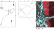
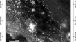
Compositional Mapping and Spectral Analysis of Sulpicius Gallus Dark Mantling Deposits Using Lunar Orbital Data Sets Including Chandrayaan-1 Moon Mineralogy Mapper P. R. KumaresanJ. Saravanavel Research Article 14 March 2022 Pages: 1301 - 1319
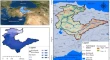
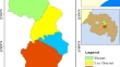
Geospatial and AHP Approach Rainwater Harvesting Site Identification in Drought-Prone Areas, South Gonder Zone, Northwest Ethiopia Endalkachew Sisay YegizawMulualem Asfaw EjeguTiku Melak Dirar Research Article 15 March 2022 Pages: 1321 - 1331
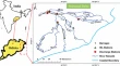
Evaluation of Satellite Rainfall Estimates in a Rugged Topographical Basin Over South Gojjam Basin, Ethiopia Demelash Ademe MaledeTena Alamirew AgumassieTesfa Gebrie Andualem Research Article 22 March 2022 Pages: 1333 - 1346
Analysis of Spatiotemporal Land Subsidence Patterns of Suzhou City, China, over the Past 15 years Based on Multisource SAR Data Yanyan LuDeliang ChenYuanyuan Chen Research Article 24 March 2022 Pages: 1347 - 1369
Temporal Land-Use/Land-Cover Change Analysis in Kotla Sub-Watershed of Rupnagar District (Punjab) Using Remote Sensing and GIS Amritpal DigraArun KaushalDhruval Bhavsar Research Article 28 March 2022 Pages: 1371 - 1391
Estimation of Vertisols Soil Nutrients by Hyperion Satellite Data: Case Study in Deccan Plateau of India Vinod TamburiAmba ShettyS. Shrihari Research Article 28 March 2022 Pages: 1393 - 1404
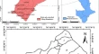
Changing Trends of Aerosol Loadings Over Three Major Zones of Indian Region During the Last Seventeen Years (2005–2021) Manu MehtaPraveen SharmaPrakash Chauhan Short Note 27 March 2022 Pages: 1405 - 1408