Let us create flood hazard maps for developing countries Emlyn HagenX. X. Lu Short Communication 24 February 2011 Pages: 841 - 843
Using disaster footprints, population databases and GIS to overcome persistent problems for human impact assessment in flood events Debarati Guha-SapirJose M. Rodriguez-LlanesThomas Jakubicka Short Communication 15 March 2011 Pages: 845 - 852
Should we design buildings for lower-probability earthquake motion? Hing-Ho Tsang Short Communication Open access 03 April 2011 Pages: 853 - 857
Field survey report on the 11th March 2011 tsunami in Pacific coast of Mexico M. P. JonathanP. D. RoyC. Lakshumanan Short Communication 15 June 2011 Pages: 859 - 864
Modelling the flood vulnerability of deltaic Kuching City, Malaysia Darrien Yau Seng MahFrederik Josep PutuhenaSai Hin Lai Technical Note 02 February 2011 Pages: 865 - 875
Radon as seismic precursor: new data with well water of Jalpaiguri, India Dipak GhoshArgha DebRosalima Sengupta Original Paper 09 January 2011 Pages: 877 - 889
Snow cover depletion under changed climate with the help of remote sensing and temperature data Sanjay K. JainL. N. ThakuralS. K. Mishra Original Paper 28 December 2010 Pages: 891 - 904
Stakeholders’ perception in identification of river bank erosion hazard: a case study Bela Das Original Paper 18 February 2011 Pages: 905 - 928
Impact of satellite observed microwave SST on the simulation of tropical cyclones Vishal BongirwarV. RakeshP. C. Joshi Original Paper 26 January 2011 Pages: 929 - 944
Impact of satellite soundings on the simulation of heavy rainfall associated with tropical depressions V. RakeshR. SinghP. C. Joshi Original Paper 29 December 2010 Pages: 945 - 980
The role of the diagnostic areas in the assessment of landslide susceptibility models: a test in the sicilian chain E. RotiglianoV. AgnesiC. Conoscenti Original Paper 11 January 2011 Pages: 981 - 999
Hazard assessment at Mount Etna using a hybrid lava flow inundation model and satellite-based land classification Andrew J. L. HarrisMassimiliano FavalliHarold Garbeil Original Paper 20 January 2011 Pages: 1001 - 1027
Modeling of inundation dynamics on Banda Aceh, Indonesia during the great Sumatra tsunamis December 26, 2004 Gegar PrasetyaJose BorreroTerry Healy Original Paper 24 February 2011 Pages: 1029 - 1055
Flash flood routing modeling for levee-breaks and overbank flows due to typhoon events in a complicated river system Wen-Cheng LiuChung-Yi Wu Original Paper 11 January 2011 Pages: 1057 - 1076
Thunderstorm Hazard vulnerability for the Atlanta, Georgia metropolitan region Marius J. PaulikasWalker S. Ashley Original Paper 14 January 2011 Pages: 1077 - 1092
The logistics of household hurricane evacuation Michael K. LindellJung Eun KangCarla S. Prater Original Paper 15 January 2011 Pages: 1093 - 1109
A seismological study of shallow weak micro-earthquakes in the urban area of Hamburg city, Germany, and its possible relation to salt dissolution Torsten DahmSebastian HeimannWilhelm Bialowons Original Paper 21 January 2011 Pages: 1111 - 1134
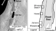
Sinkhole characterization in the Dead Sea area using airborne laser scanning Sagi FilinAmit BaruchShmuel Marco Original Paper 28 January 2011 Pages: 1135 - 1154
Scaling property of regional floods in New South Wales Australia Elias IshakKhaled HaddadAtaur Rahman Original Paper 22 January 2011 Pages: 1155 - 1167
Quantitative multi-risk analysis for natural hazards: a framework for multi-risk modelling Jochen SchmidtIain MatchamDave Heron Original Paper 28 January 2011 Pages: 1169 - 1192
Performance evaluation of disaster monitoring systems Tuncay Bayrak Original Paper 25 January 2011 Pages: 1193 - 1208
Causes of catastrophic failure of Tam Pokhari moraine dam in the Mt. Everest region Rabindra OstiTara Nidhi BhattaraiKatsuhito Miyake Original Paper 22 January 2011 Pages: 1209 - 1223
Analysis of explosions and seismic phenomena based on electromagnetic cracking of piezoelectric and piezomagnetic plates S. KoshevayaN. MakaretsR. Perez-Enriquez Original Paper 13 February 2011 Pages: 1225 - 1232
Geomagnetic anomaly at Lunping before the 1999 Chi-Chi earthquake (M w = 7.6) in Taiwan Kuang-Jung ChenBonbbon ChiuKevin Chao Original Paper 30 January 2011 Pages: 1233 - 1252
Earthquake shaking probabilities for communities on Vancouver Island, British Columbia, Canada Mark SeemannTuna OnurDenise Cloutier-Fisher Original Paper 05 February 2011 Pages: 1253 - 1273
Monitoring Koyulhisar landslide using rapid static GPS: a strategy to remove biases from vertical velocities K. O. HastaogluD. U. Sanli Original Paper 30 January 2011 Pages: 1275 - 1294
An integrated flood risk assessment model for property insurance industry in Taiwan Wen-Ko HsuPei-Chiung HuangWei-Ling Chiang Original Paper 08 February 2011 Pages: 1295 - 1309
Using differential SAR interferometry to map land subsidence: a case study in the Pingtung Plain of SW Taiwan Chia-Sheng HsiehTian-Yuan ShihJacques Angelier Original Paper 18 February 2011 Pages: 1311 - 1332
Analysis of extreme low-temperature events during the warm season in Northeast China Xiao FengjinSong Lianchun Original Paper 10 February 2011 Pages: 1333 - 1344