
Abstract
The Valencian coastal plains are formed at the end of two important mountain systems: the Iberian Mountain Range to the north and the Baetic Mountains to the south. As a result of tectonic and neotectonic activity, several graben have been formed at the foot of these reliefs, which have been filled with Plio-Quaternary deposits. In all the coastal plains a depositional sequence is repeated in which the river deposits -fan deltas and alluvial plains- alternate with lagoons/marshes. Basin dimensions, sediment input, tectonics and neotectonics in the study area all determine the size, style and characteristics of fluvial forms, which in turn, influence the characteristics of the coast. Ephemeral rivers form prograding fan deltas when there is little subsidence or tectonic stability dominates. Aggrading fan deltas appear when subsidence predominates. The former make the coast protrude, while the latter are associated with straight coasts. On the other hand, due to the runoff scarcity, ephemeral streams provide fewer sediment inputs to the coastal system than perennial rivers. In addition, during flooding, both ephemeral and perennial rivers provide water and sediment to the lagoons, which are filled and transformed into marshes.
1 The Relief: Large Structural Units
The València region consists of two great mountain alignments formed during the Alpine orogeny—to the north, the Iberian System (NW-SE), to the south, the Baetic System (NE-SW)—and a central sector which is a transition area between the two. In the northern Iberian sector, carbonated Mesozoic materials of marine origin predominate, which were folded into anticlines and synclines during the paroxysmal phase of the Alpine orogeny during the Oligocene period. During the Miocene, a series of folds transversal to the direction of the mountain system were formed (Garay 1995). At the end of the Tertiary and the beginning of the Quaternary periods, two new distensive phases took place, which fractured the reliefs about 10–30 km from the coast to form a stepped series of horsts and graben going NE-SW down towards the sea. During the Quaternary, the rivers eroded the horsts and filled up the coastal plains.
The central area of València region is a transition between the Iberian and the Baetic mountain chains. The Caroig platform is a sub-tabular relief formed by limestone from the Jurassic and Cretaceous periods and located about 40 km from the coast. In the eastern part of this platform, there is a wide trench with a base of tertiary materials fill up by quaternary fluvial sediments carried by the Xúquer and Túria rivers (Fig. 21.1).

Valencian coastal plains: the study area and the most important fluvial forms
The southern area belongs to the Baetic System and was folded during the first half of the Miocene. The northern part belongs to the External Prebaetic and consists of numerous folds running in an ENE-WSW direction. The reliefs are anticlines formed by Jurassic and Cretaceous limestone materials and the valleys are synclines formed by Miocene marls. Unlike the Iberian System, the reliefs reach the coast to form cliffs. To the SW is the Sub-Baetic area formed by small isolated Jurassic and Cretaceous reliefs. Further south, the Baetic area is made up of chains formed by Triassic dolomites. Finally, in the southern part of the Valencian region there is the Vega del Segura, the continuation of the Guadalentín trench which is home to a wide plain made up of Miocene deposits and Quaternary fluvial inputs carried by the Segura and Vinalopó rivers (Garay 1995).
Although there are small outcrops of siliceous sandstone and Triassic gypsum, carbonate materials (limestone, dolomite and marl) predominate in the Valencian mountains which explains their widespread and more or less accelerated karst dissolution processes. By contrast, coastal plains are formed by detritic materials of fluvial or marine origin. Thus, València region is formed by reliefs very close to the sea with a coastal plain of varying dimensions at its foot. In the northern part, this is only about 10 km but in the centre it extends to about 30 km and then disappears when the Baetic reliefs reach the sea where it is restricted to small plains between the capes. Finally, in the southern sector, the Lower Segura plain is a depression over 20 km long.
These plains are filled with Quaternary fan and floodplain deposits alternating with coastal lagoon/marsh deposits (Sanjaume 1985). These deposits are sometimes affected by neotectonic phenomena. In the central sector, between Sagunt and Dènia, the marine platform also has steps formed by faults running parallel to the coast. The major subsidence in this sector—over 200 m of sedimentary thickness—is related to neotectonics, and the same is also to be found on the Alacant coast where it has been responsible for the uplifting of some fossil beaches and the subsidence of some blocks. Furthermore, in this southern sector, from the Pliocene, NE flexures are produced, crossed with others in a N120°E direction, which forms a series of undulations with bulges (Cap de Santa Pola and Serra del Molar) and subsidence zones occupied by the lagoons of the Mata, Torrevieja, Fondó d'Elx and Santa Pola salt lake (Fig. 21.1d).
Finally, subsidence also affects the Vega del Segura. This structure would have been occupied by the sea during the Late Pliocene, but the uplifting of the reliefs mentioned above caused a regression that moved the sea to a position close to its present one (Goy et al. 1990) (Fig. 21.1d).
2 Characteristics of Valencian Rivers
From the hydrological point of view, there are two types of Valencian Rivers: perennial and ephemeral. Perennial streams channels fed by groundwater during dry periods are usually large (hundreds of km in length and thousands of km2 in basin) and flow through non-Mediterranean climatic zones. They usually have gentle slopes and meandering courses, carry fine sediment and create wide floodplains.
Perennial rivers have river regimes that take on the characteristics of the climates they pass through. At their headwaters, they often have a fluvio-nival regime, which evolves to Mediterranean in their middle and lower basins. They cause flooding with abundant discharge, and if brought about by heavy Mediterranean-type rain (convective or cold low pressure) they have sharply peaked hydrographs with very high maximum discharges. The most important from N to S in the study area are the Túria, Xúquer and Segura rivers.
The ephemeral rivers (locally called ramblas, rius secs or barrancs) are similar to wadis and only flow after heavy and intense Mediterranean rains. They are usually short (less than 100 km in length) with small basins measuring only a few hundred km2 developed under a Mediterranean climate. In some cases, these ephemeral streams may have headwater flow when fed by local aquifers (when they are called rius), but this flow disappears downstream due to transmission losses. The reliefs’ arrangement so close to the coast leads to courses with steep slopes, carrying coarse sediment (gravel, pebbles or blocks). The high sedimentary load generates rivers with a braided or wandering path. When the channels reach the coastal plains, the slope changes abruptly and the channels lose confinement (Segura 1990).
In addition, when passing from the calcareous rocks, dominant of the nearby reliefs, to the detritic materials of the plains, they lose part of their flow due to transmission losses. The conjunction of these factors results in a reduction in their velocity and the consequent deposition of materials forming alluvial fans, some of which reach the coast as fan deltas. When the basins are smaller, they form diminutive torrential cones at the mountain fronts.
As a consequence of heavy Mediterranean rains, the ephemeral rivers generate flash floods with sharply peaked hydrographs, very high maximum discharges, vertical rising limbs and lag time of less than one hour in many cases (Segura 1990; Camarasa and Segura 2001). Despite their small size, they cover most of the territory studied. The most important from N to S are Riu de la Sénia, Cervol, Rambla de Cervera, Riu de les Coves, Riu Millars, Riu Palància, Carraixet, Riu Serpis, Gorgos, Riu d’Algar, Amadorio, Vinalopó and Montnegre (Fig. 21.1).
3 The Coastal Plains: Interaction Between Fluvial Deposits and Lagoon/Marshes
The thickness of the Plio-Quaternary deposits of the coastal plains depends on several factors, including the tectonic structure of the trenches, subsidence, neotectonics, fluvial sedimentary inputs and eustatic changes. The combination of all these factors has created complex coastal plains where fluvial, marine and transitional processes coexist. The fluvial sediments are deposited by rivers and ephemeral streams which form wide floodplains and fan deltas. Resting over the distal parts of these forms, beach barriers have emerged closing former Holocene marine gulfs which have turned into lagoons. Over time, these spaces have been silted up and turned into marshes. Thus Valèncian’s coastal plain is an alternating sequence of fans, fan deltas and floodplains with coastal lagoons and/or marshes (Sanjaume 1985). The current lagoons/marshes were formed in the last Flandrian transgression when the sea level rose above its present level. During the maximum Flandrian transgression large marine gulfs were formed which were closed off by beach barriers in the following regressive period. The fluvial network was adapted to this base level. As a result, current rivers with smaller basins continue to flow into the inner side of the marshes, while rivers with larger basins reach the sea. Figure 21.1 shows the sequence of these fluvial forms and the lagoons that mark the coastal plains. Tectonics and neotectonics have fragmented these plains and the continental shelf into blocks which had differentiated behaviours during the Quaternary period. Stability, uplift and subsidence have determined the distribution and sedimentary thickness of the fluvial deposits and lagoons. Broadly speaking, in the northern sector stability or slight subsidence predominated. By contrast, the Valencian continental shelf between Sagunt and Cap de la Nau sank significantly in the Pleistocene and the subsidence rate declined progressively during the Holocene. Garay (1995) refers marked subsidence near the coast where Quaternary sediment thickness over 200 m has been detected. There was an uplift of blocks in the south-west of the province of Alacant as far as the Mar Menor, suggesting a different dynamic (Rey et al. 1999), although some blocks in the Segura basin indicate major subsidence. The coastal environments are also subject to continuous displacement on the continental shelf. Studies carried out by some researchers show that the river inputs form prograding bodies on the shelf, albeit with differential deposition. In general, the shelf is very wide in the Gulf of València and has very thick deposits, whereas from Cap de Sant Antoni, the shelf and sedimentary thickness decrease due to the Baetic sector’s morphostructure. Fluvial deposits corresponding to current and relict pro-deltas have been identified right across the shelf (Rey et al. 1999).
4 River Deposits on the Coastal Plain
The arrangement and characteristics of the different sedimentary forms on the coastal plains vary significantly depending on the type of river, basin dimensions, tectonics, neotectonics, base-level changes, etc. (Bardají et al. 1990; Silva et al. 2003; Viseras et al. 2003). These variables result in two types of deposits on the Valencian coastal plains: alluvial fans/fan deltas and floodplains. By contrast, in the raised southern areas, the rivers cut through ancient Plio-Quaternary glacis.
4.1 Origin and Types of Alluvial Fans and Fans Deltas
As noted above, the characteristics of the Valencian coastal plains lead to the formation of alluvial fans and fan deltas. These forms have been described in the local literature as alluvial fans (Mateu 1982; Segura 1990; Viseras et al. 2003) although some of them discharge into the sea or the lagoons and therefore can also be considered as fan deltas. The terminological discussion conducted in the literature also appears in this case (McPherson et al. 1987; Nemec and Steel, 1988; Dijk et al. 2012). Fan deltas represent interaction between heavily sediment-laden alluvial-fan systems and marine or lacustrine processes (Nemec and Steel 1988). It is difficult to use the term fan delta in the strict sense in these coastal plains. The particle size is large and fluvial processes are dominant in the study area due to its low wave energy and negligible tidal range. Furthermore, prograding of various levels of fans throughout the Quaternary means that only Holocene build-ups have a marine influence today. Consequently, the terms alluvial fan and fan delta are used interchangeably in this paper.
These fluvial forms can be classified in different ways:
-
(a)
By their geometry and depositional facies. According to Nemec and Steel (1988), there are a range of forms in the Valencian alluvial plains (Table 21.1):
Tab. 21.1 Physical characteristics of perennial rivers and ephemeral streams of Valencian coastal plains -
1.
Alluvial fans are semi-conical or triangular-shaped (in plan view) accumulations at the mouths of valleys, associated with active tectonic scarps. They develop when a stream emerges from a confined region onto a plain. Examples would be the alluvial fan of the Magre River, tributary of the Xuquer River, near of its mouth (Fig. 21.1c).
-
2.
A fan delta is a coastal prism of sediments formed by an alluvial-fan system and deposited, mainly or entirely subaqueously, at the interface between the active fan and a standing body of water (marine or lacustrine). Most of the examples analysed in this paper are of this type. A fan delta is the actual delta of an alluvial fan, while a delta is formed by a river. There are many transitional forms between these forms.
-
3.
A fan-delta complex consists of coalescent or vertically stacked fan-delta lobes created by an alluvial fan or fans (Nemec and Steel 1988).
-
4.
A braidplain delta is the delta of a braidplain that shows no direct upstream transition into ‘proximal’ alluvial-fan deposits. This could be the case of the Túria River floodplain (Fig. 21.1b).
-
1.
-
(b)
By fan style
Throughout the Quaternary, there were different stages of sedimentation and incision, which have led to terraces and alluvial fans/fan deltas. Terraces in the Valencian coastal plains can be correlated with different levels of fans/fan deltas at the mountain front. Harvey (2012) suggests that regional aggradation of alluvial fans and river terraces appears to have coincided with Pleistocene glacial phases and periods of dissection with interglacials. By contrast, the Holocene coincides with an aggrading phase that is associated with anthropic action.
There are two types of alluvial fans and terraces based on their arrangement: prograding and overlapping or aggrading (Fig. 21.2). The first is a type of fan-head trenching and distal aggradation and has been called in different ways by other authors (telescoping fans, Nemec and Steel 1988; prograding fans, Harvey 2012). Prograding can be caused by several factors s: (a) a high sedimentary load (Harvey 2012); (b) lowering of the sea level; or (c) little subsidence. Aggrading fan (Nemec and Steel 1988; Harvey 2012) presents different levels of overlapped Quaternary fans. The cause is usually faulting or downwarping persistence and subsidence is fairly uniform, so the fan is very thick at its apex (Nemec et al. 1988).
Fig. 21.2 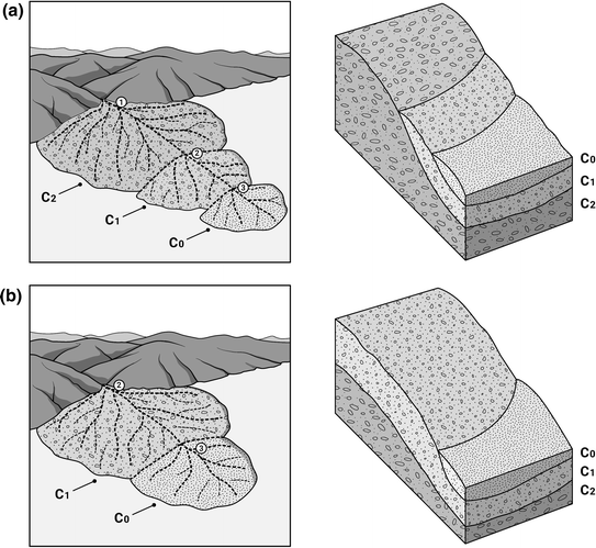
Alluvian fan delta models. C2: Early and Middle Pleistocene fan; C1: Late Pleistocene fan; C0: Holocene fan. a Prograding fan model. On the surface, there is the encrusted fan of the Early-Middle Pleistocene and in a prograding succession, the Late Pleistocene and the Holocene (both not encrusted). b Aggrading fan delta model. The Late Pleistocene fan (not crusted) appears on the surface and the Holocene fan on the distal part. If the river is incised, the crusted fan of the Eaely Pleistocene appears on the riverbed
-
(c)
By their spatial location
The Valencian coastal plains’ fan deltas may drain directly into the sea or the lagoons. The former are bigger and generated by streams with larger basins. The latter border the lagoons on their inner side since this was the base level of these rivers during the Flandrian transgression. As they have small basins, the low sediment supply leads to small progradation over the wetland, although they are not able to completely fill the marshes.
From the point of view of sedimentation, fan deltas are formed by fluvial processes, and some cases of levels of erosive coast (highstands) and intercalated beaches can only be found in their distal part, especially on the Alacant coastline (Bardají et al. 1990).

4.2 Floodplains
The largest perennial rivers are meandering and develop major convex floodplains with a channel that is raised and bordered by levees. Vertical accretion and fine materials (silts and clays) predominate. Their forms include dykes or levees, lateral flood basins, yazoos, point bars, abandoned meanders, and crevasse splays. They are low-energy plains, whose specific stream power at bank full stage is generally lower than 10 Wm−2 (Charlton 2008). This group includes the Xúquer and Segura floodplains (Figs. 21.1, 21.7 and 21.8).
4.3 Glacis
To the south of Cap de la Nau, coinciding with a sector where precipitation decreases and aridity increases, the drainage network blurred and there are some sectors where it has been disorganised by neotectonics. In these areas, there are large glacis with a gentle slope of between 3° and 8°. They are often stepped and dissected by fluvial courses and have several levels of terraces. They frequently have crusted surfaces on which there are sometimes flat-bed ravines. Their origin is complex and the lateral shift from glacis to fluvial terraces is frequent (Fig. 21.1d, e). The age of these forms has been widely discussed. The older ones are considered to be from the Late Pliocene or Early Pleistocene, although several subsequent levels occur. As for their origin, Cuenca and Walker (1985) associate the Plio-Pleistocene glacis (2.6–2.8 mya) with the existence of lacustrine zones fed by currents that descended from the slopes in a warm climate with strong contrasts of precipitation. In addition, there are several levels dating between 39,000 (Late Pleistocene) and the Holocene with different climatic oscillations (Rosselló 1978).
5 Geographical Distribution of the Main Coastal Alluvial Forms
There are a number of sectors on the Valencian coastal plains with similar fluvial forms. From north to south, they are as follows:
5.1 Sector Ebro Delta—Serra D’Irta
This is a sector formed by horst and graben crossed by ephemeral streams which build large alluvial fans. There are two subareas:
-
(a)
Vinaròs-Benicarló-Peníscola plain (Fig. 21.3). This is a tectonic trench running between the Ebro Delta and the Peníscola tombolo. It is filled by a fan delta complex formed by the Sénia, Cervol, Rambla de Cervera and Rambla d’Alcalà rivers. The first three form a thick alluvial bajada formed by a prograding sequence of three levels of alluvial fans. The oldest, from the Early-Middle Pleistocene, have been deposited at the front of the reliefs and they are formed by a conglomerate of cobbles, pebbles and gravel with a clay-silt matrix and covered with a calcareous crust. The Late Pleistocene fans have finer materials (gravel, sand, silt and clay) not crusted. Finally, near the coastline, the Holocene fans are made up of fine materials (silt, sand and clay). They have been eroded by the sea in their distal part leaving a coastline of medium-height cliffs. This erosion is directly related to the lack of coastal nourishment generated by the growth of the Ebro Delta, which has retained the sediments supplied by this river (Sanjaume et al. 1996; Pardo Pascual and Sanjaume Saumell 2001). The southern part of the Vinaròs-Benicarló plain is formed by an Early-Middle Pleistocene fan, deposited by the Rambla d’ Alcalà. This form lies perpendicular to the previous fans given the NNE-SSW route of this ephemeral stream (Fig. 21.3). When it meets the Rambla de Cervera fans, the Rambla d’Alcalà turns through a 90° angle, which means that the Late Pleistocene deposits run parallel to those of the northern ephemeral streams. Holocene materials are deposited near the mouth. On them rests the beach barrier that closes the small Peníscola lagoon, now silted up. There is a semi-endorheic space between the Rambla d’Alcalà and Rambla de Cervera fans (Segura 1990; 1996).
Fig. 21.3 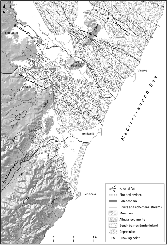
Vinaròs-Benicarló coastal plain. A fan delta complex formed by the Riu de la Sénia, Riu Cervol, Rambla de Cervera and Rambla d’Alcalà agradding fan deltas. In the southern part, the Peníscola lagoon is formed. Barranc d’Aigua Oliva and Barranc de la Barbiguera are interfan rivers
-
(b)
The Serra d’Irta is a horst, which reaches the coast where it forms a cliff. At the foot of this cliff, there are small fan deltas whose distal part has been eroded by the sea to create a low cliff on a coastline broken up by small calas (Fig. 21.1a).

5.2 Sector Orpesa-Torreblanca Plain
This is a trench formed during the Miocene distension and compartmentalised in several blocks. The thickness of the Plio-Quaternary sediments ranges between 20 and 150 m. A number of studies see greater subsidence in the southern sector than in the northern one (Fig. 21.1a) (Segura et al. 1997, 2005).
In the northern part, the Riu de les Coves generates a prograding fan delta whose distal end forms the coastal protuberance of Capicorb (Fig. 21.4). It has a crusted surface formed by pebbles and blocks that is attributed on a regional basis to the Early-Middle Pleistocene. The Late Pleistocene level, formed by loose materials with an abundant matrix, appears in the form of terraces, suggesting that the fan delta was deposited offshore and has been destroyed. The Holocene sediments are located south of the current mouth, forming a small protuberance that could be associated with some perhaps very recent diffluence. It is thus a prograding fan delta (Segura 1990) which was larger in the past and has since been eroded by the sea, probably due to the lack of sediment input found throughout this northern Valencian sector because of the Ebro Delta’s growth.

Les Coves River fan delta. The prograding fan forms the Capicorb protuberance in the coastline. Several paleochannels show the channel mobility throughout the Quaternary period
The complex alluvial fan formed by the Riu Xinxilla-Barranc de la Font del Campello-Barranc dels Llorenços (Fig. 21.1a) in the southern part of the plain is smaller than the previous one. It supports the Torreblanca and the Orpesa lagoon beach barriers to the north and south respectively. It is an aggrading fan delta whose growth has divided a continuous lagoon developed between Torreblanca and Orpesa into two parts. Finally, the inner side of the Torreblanca lagoon is framed by small prograding fan deltas formed by streams that descend from the nearby reliefs (Fig. 21.1a) (Segura et al. 1997, 2005).
5.3 Sector Benicàssim—Castelló
The coastal plain has a morphogenetic scheme similar to the rest of the Gulf of València: at the foot of the reliefs, a few kilometres from the coast, an alluvial bajada starts in Benicàssim and ends with Riu Millars-Rambla de la Viuda fan-delta (Fig. 21.5). A long, narrow beach barrier grew between the two protuberances that closed off a lagoon, now turned into a marsh. It is a fan-delta complex formed by the coalescence of the fans growing at the foot of the Massís del Desert de les Palmes. It is wider in Benicàssim, where several fan deltas flow into the sea filling the marsh. It narrows considerably on the inner side of the marsh, where the smaller ravines end and the wetland widens. In the southern sector, the Riu Sec de Borriol flows into the coastal plain after draining a small interior trench. The convex topography of the alluvial fan of the Riu Millars-Rambla de la Viuda forces the Riu Sec de Borriol to make a 90° turn and build its own fan by encroaching on the Prat del Quadro marsh. Although the fan progrades in the wetland, the natural channel disappears at this point. Construction of an artificial channel in the second half of the 20th century enabled this river to flow into the sea (Segura 2001).

The prograding fan delta of the Millars River and Rambla de la Viuda coalesces with the others created by the Riu Sec de Borriol and Riu Sec de Borriana, forming a protuberance that limits and interrupts a continuous space of marshes
The fan-delta complex formed by the Riu Millars-Rambla de la Viuda is prograding and in its advance has managed to fill the marsh, which at this point is interrupted. With a very complex structure, which has been caused by the mobility of both channels throughout the Quaternary, its deposits contain several levels of fans (dated on a regional basis) (Fig. 21.5). The oldest is represented by fragments of Tertiary deposits, which may have been the result of the first avulsions of the Millars river. In the Early-Middle Pleistocene, two fans were formed represented by a powerful conglomerate with a calcareous crust on top on which sheet floods can be seen. At this time the Millars and the Rambla de la Viuda did not end together and some authors suggest the latter drained into an interior trench (Mateu 1982). Its mouth in the coastal plain would be later than this period. Downstream of the confluence of the two rivers, there is a new intersection point where a new Late Pleistocene fan starts. It is formed by loose materials and with a smaller size than the oldest level. Also downstream (Almassora town) there is a Holocene fan delta formed by loose materials with a silt-clayey matrix which extends towards the coast. It should be noted that there are several paleochannels, hanging over the current channel, which drain fan runoff during torrential rains and cause flooding, independently of the main channel. The Millars-Rambla de la Viuda fan coalesces in the south with another fan formed by the Riu Sec de Borriana and its numerous tributaries that have been interpreted as ancient paleochannels of the Millars River (Segura 2006) (Fig. 21.5).
5.4 Sector Castelló-Sagunt
A beach barrier extended between the Millars-Rambla de la Viuda and Riu Palància fans closing off an uninterrupted marshy area (Fig. 21.1b). The alluvial bajada becomes smaller and there are only small fans that discharge into the inner side of the marsh. The most important depositional form in the sector is the Riu Palància’s aggrading fan delta which has an almost perfect conical morphology (Fig. 21.6). At the front of the mountain, there is the apex of a Late Pleistocene fan with deposits similar to those of other fans from the same period. Numerous paleochannels have been identified on this fan hanging above the main bed with different degrees of incision. During flooding periods, they collect runoff from the fan and take it to the coast or in some cases to the surrounding marshes (Segura 1991). This fan overlaps another crusted fan formed in the Early Pleistocene, exposed by erosion into the bed. A Holocene fan starts near the river mouth.

The aggrading fan of the Palancia River interrupts a marshy area. It is crossed by numerous paleochannels that drain surface water to the sea and lateral marshes during periods of flooding
5.5 Sector Sagunt-València
A beach barrier has formed, resting on the Palància fan and the Túria floodplain, which closes off a narrow uninterrupted marshy area (Fig. 21.1b). The alluvial bajada that borders the inner side of this area is formed by small fan deltas that begin in the adjoining reliefs. The most important forms include the Carraixet’s fan delta which, when it reached the plain, formed a fan delta dated to the Late Pleistocene. The Carraixet’s inputs narrowed the marsh (Fig. 21.7). The interaction of natural and anthropic processes has been exceptionally active in this sector. In fact, the Carraixet’s final course is probably of human origin to avoid the repeated flooding which this horticultural sector to the north of the city of València would otherwise experience.
5.6 Sector València-Cullera
This sector is made up of the inputs from the two great Valencian rivers: the Túria and the Xúquer. The first forms a braidplain delta where a Pleistocene alluvial fan with a 0.45% slope can be clearly identified, formed by red silt and clays with calcareous nodules and calcretes. About 6 km from the coast, Holocene deposits bury the middle and distal sector of the Pleistocene fan, forming an alluvial plain with a 0.2% slope (Fig. 21.7). Residual marshes are located on its sides and on the distal part of this floodplain is the beach barrier that closes the València lagoon, which extends to Cap de Cullera.

The central floodplains formed by the Turia and Xúquer Rivers, are separated by the Albufera lagoon and marshy area. During flood events, both rivers bring flow to the sea and to the adjacent lagoons (the València lagoon and others located the north and south of both rivers). a Mercat and Predicadors paleochannels, b Braç de Roca paleochannel, c Braç del Grau paleochannel. With information from Ruiz, Carmona and Mateu (2006) and Carmona and Ruiz (2011)
The city of València was founded on a terrace on the right bank in 138 BC in Roman times. At this time, the coastline was deep inland (Carmona 1990; Carmona and Ruiz 2011). On the plain, in addition to the main channel, several paleochannels have been identified which come into operation during floods. There are two on the right bank: (a) the Mercat paleochannel, which borders the Arab wall, and (b) the Rambla de Predicadors, which skirts an ancient river island. On the left bank, there are two more: the Camí del Grau and la Rambla (Carmona and Ruiz 2011). There are two more paleochannels on the right bank in the river mouth area which take water flows to the València lagoon and two more that carry them towards the coast marshes (Carmona and Ruiz 2014; Portugués-Mollá et al. 2016). There are also several lacustrine areas in this floodplain. The València lagoon, which runs from the Túria’s mouth to Cap de Cullera, is still functional today but there are also others which have been silted up by the progradation of the Túria (Carmona and Ruiz 2011).
Based on the sedimentological, stratigraphic and archaeological data, Carmona and Ruiz (2011) has determined the Holocene evolution of the sector. The Flandrian transgression penetrated towards the interior of the continent and the pre-Holocene valleys formed shallow and possibly branched inlets in a shallow coastal lagoon environment. During the late Holocene, the progradation of the coastal sandy ridges and the aggradation of the floodplain took place, caused by an increase of the sediment supplied. The floodplain evolution included several growth periods with different sedimentary inputs: (a) High magnitude flood events (2800 BP to the 3rd century BC); (b) Slow riverbed aggradation and progressive levee formation in Roman times (from the 2nd century BC to the 5th century AD); (c) Swampy environmental processes (6–9th centuries); and (d) Second phase of high-magnitude floods (11th century). River floods in the Roman and Islamic periods are interpreted as a consequence of anthropic activity (deforestation) associated with the expansion of crops. The formation of swamps in Visigothic times (6–9th centuries) is believed to be due to the opposite effect, i.e. to the recovery of vegetation resulting from a decline in agriculture (Carmona 2016).
The current arrangement of the main channel and the paleochannels generates a particular dynamic during extraordinary flooding: part of the flow drains into the sea, but another part flows into the lateral marshes, especially towards the València lagoon, where the river built an interior delta during the Holocene (Rosselló 1972; Carmona and Ruiz 2014).
5.7 Sector Cullera-Pego
The most important river form in the sector is the Xúquer floodplain. It has a slope of 0.1%, with a concave or convex morphology depending on the sectors. The river is meandering, presenting some historical mobility (Mateu 2000; Ruiz, 2002) and is bordered by dikes or levees, raised between 3 and 6 m above the lateral flood basins, where fluvial marshes have grown. Near its mouth, these floodplain marshes join to the coastal ones to form a large wetland that floods during high magnitude flood events (Fig. 21.7). It is a Holocene floodplain, embedded between Pleistocene terraces and alluvial fans that constrain the plain in some sectors (Magre and minor alluvial fans). In the lateral flood basins, overflows are organised in the two yazoos, the Riu Verd (left bank) and the Riu Barxeta (right bank) (Mateu 2000).
An important feature of the river is that it has overflow branches that are activated during extraordinary floods (Fig. 21.7). Part of the water flows through the current channel, but another part flows through the Barranc del Duc, a branch that collects the overflow and steers it towards the sea and the marshes on the right bank. On the left, the overflowing water is guided towards the Albufera marshes by another secondary branch (La Roca and Carmona 1983, Carmona and Ruiz 2014). The construction of the deltaic plain has been studied by Ruiz (2002), Ruiz and Carmona (2005), Ruiz et al. (2006). During the Flandrian transgression, the coastline was several hundred metres further back from where it is today and a beach barrier isolated a wide lagoon area that extended between the Túria and the Xúquer. An inner delta which developed between 6000 and 3000 BP drained into this lagoon, as happened in the north with the Túria. Between 3000 BP and the Middle Ages the lower basin’s meander train and floodplain were built over the previous deltaic environments and there was significant Islamic settlement in these areas at the end of the Middle Ages. As a consequence of this fluvial activity, there has been strong vertical and horizontal accretion in the floodplain altering the topography. This has led to the depopulation of some historic urban centres located in lateral marshy areas (Mateu 2000). In adition, there is a narrow marsh to the south of the Xúquer’s mouth running as far as Gandia (Fig. 21.1c), which experienced significant progradation throughout the Holocene, as evidenced by the existence of a twin beach barrier. However, on the inner side of this area there are hardly any significant river inputs (Sanjaume and Pardo-Pascual 2003). The Gandia plain is a triangular saging structure formed in the transition area between the Iberian system and the Baetic ranges. The trench was filled in the Quaternary with inputs from the Riu Serpis and other minor channels. The Riu Serpis discharges in the north of the plain but two more southern paleochannels can be observed in the fan which suggests that the river has migrated northwards. It is an aggrading fan delta since surface deposits typical of the Middle Pleistocene are not found there (Segura and Carmona1999). At 1.5 km from the coast, the Serpis fan has a step, delimited by the 5 m isohipse, which has been interpreted as a Flandrian beach (Viñals 1996).
5.8 Sector Pego-Dénia
In the Pego sector, tectonic forces formed a triangular trench with a Mesozoic substrate featuring several blocks that descend in steps towards the coast, flanked by raised blocks to the north, south and west (Ballesteros et al. 2009). There are several aggrading fan deltas at the front of the reliefs on the edges of the triangle and the Pego-Oliva marsh at its distal part (Fig. 21.1c). Throughout the Quaternary, the major subsidence in the sector and the numerous transgressions and regressions led to the formation of an aggrading fan delta created by the Riu Bullent. In the sedimentary complex, continental facies alternate with different sedimentary environments. Continental sedimentation is due to the growth of the alluvial fans between Marine Isotopic Stage (MIS) 11 and MIS 7 whereas between MIS 15 and MIS 12, transition environments predominated (brackish marsh-lagoon periods); subsequently a lagoon system took shape between MIS5 and MIS 1 which has lasted until today (Dupré et al. 1988; Viñals 1996; Torres et al. 2014).
To the south of Pego there is a new triangular trench filled by Tertiary and Quaternary sediments from the Riu Girona and other smaller streams that form a fan delta complex of prograding alluvial fans (Fig. 21.1d). The internal stratigraphy of these systems reveals an ‘ageing’ sequence. In the inner part of this depression is the apex of the Early Pleistocene fan formed by the Riu Girona. The Middle and Late Pleistocene fans are prograding to the sea. The latter has several lobes that suggest that the river migrated laterally during this period, forming a small Holocene fan delta (Segura 2009; Segura-Beltrán et al. 2016).
5.9 Alluvial Plains of the Baetic Mountain Ranges
When the Baetic ranges reach the sea, they form a seafront of cliffs. These mountainous alignments, consisting mainly of Mesozoic limestone and marls, are interrupted by an extensive network of orthogonal faults that compartmentalise the relief in small trenches filled with Plio-Quaternary sediments. There are several fluvial plains formed by the Gorgos, Algar, Amadorio and Montnegre rivers in this sector (Fig. 21.1d).
The Bay of Xàbia is a triangular trench between the spurs formed by Cap de Sant Antoni and Cap de la Nau. The Riu Gorgos flows into it, forming an alluvial fan in the Late Pleistocene embedded between three levels of terraces from the Middle Pleistocene. Two of these terraces are elevated by the neotectonic activity of the faults that compartmentalise the sector in blocks (Blázquez 1999). The thickness of fluvial sediments varies in the floodplain in line with the differing subsidence of the blocks, which varied throughout the Quaternary. Xàbia as a whole has much higher subsidence rates than the northernmost sectors of the València coastal plains, although the rate decreases from the Tyrrhenian stage onwards (Viñals and Fumanal 1995).
To the south of Cap de la Nau the coast forms a cliff broken up by numerous capes and bays resulting from recent fractures. Subsidence in this area during the Early Pleistocene led the coastal front to retreat. This disorganised the drainage network flowing into the sea by increasing its slope towards the E. As a result, starting in the Middle Pleistocene, the drainage network was hierarchised by headward erosion and became embedded in a Villafranchian glacis, with thick calcareous crusts and the few Quaternary deposits covering the valley (Blázquez 1999).
Further south, between Altea and Benidorm, there is the shift from the external Prebaetic system to the Subbaetic or internal Prebaetic system. A complex network of fractures forms a large number of individual blocks, and this, combined with the presence of Keuper deposits, greatly complicates the relief arrangement. The diapiric outcrops distort the deposits and neotectonic movements become prominent. The area’s geomorphology is characterised by the development of glacis and alluvial fans, which start in the nearby reliefs tilted towards the sea. In their distal part, they connect with narrow and very short systems of terraces which the rivers run between.
The Altea coastal plain would be a good example of this geomorphological structure, although in this case it would be necessary to add the halokinetic-movements due to the plasticity of the Trias that have lifted up some parts of the plain. The Riu Algar’s fluvial deposits barely form a narrow fan, which must have been larger during the Pleistocene period since they extend under the sea on the shelf (Fig. 21.1d) (Blázquez 1999). The Riu Amadorio reaches the coastal plain constricted by flysch deposits. It traces a wide alluvial fan with some diffluence. Further to the south, the Riu Montnegre and some small ravines form a prograding fan delta complex with Pleistocene deposits on the surface and a small protuberance at the mouth of the Montnegre formed by Holocene deposits (Fig. 21.1d).
5.10 Sector Segura-Vinalopó Plain
This consists of a subsidence structure delimited to the north by a strike-slip fault (Crevillent fault, the continuation of the Cadiz-Alicante fault system, CF) and to the south by the Segura fault (ENE-WSW) (BSF) where the river flows. In addition, the San Miguel and Torrevieja Faults cross the Lower Segura valley, reaching the Torrevieja and La Mata lagoons (Fig. 21.8). The complex tectonics of the sector have left a set of sagged and elevated blocks. The subsidence axes are: (a) Elx-N of Santa Pola, (b) Lower Segura and (c) Orihuela-San Miguel de Salinas, which hosts the Fondó d’Elx and the Santa Pola, La Mata and Torrevieja lagoons. Offsetting this subsidence are three raised areas: Serra dels Colmenars, Serra del Molar and Serra de Santa Pola. Some authors have interpreted these structures as anticlines and synclines (García and Martínez 2006) while others consider them horst and graben (Blázquez 2001).

The Segura floodplain and the Vinalopó aggrading fan is a complex space formed by sunken and elevated blocks created by neotectonics. The sunken areas are occupied by lagoons and salt lakes, separated by small relieves. A wide marine gulf formed during the tertiary period turned into a large lake (Sinus Ilicitanus) and was filled by alluvial deposits of the Segura River and the overlapping fan of the Vinalopo River. With information of Ferrer and Blázquez (1999), Blázquez (2001), Viseras et al. (2003)
The evolution of the sector is complex and has been interpreted in a number of ways, although all authors recognise the importance of neotectonics (Alfaro 1995; Soria et al. 2001), which have affected continental and littoral Pleistocene and Holocene sediments. The pre-Quaternary substrate is of marine origin from the Mio-Pliocene epoch and is formed by calcarenites, marls, silts and clays that emerge in the Crevillent, Colmenar, Molar and Santa Pola mountain ranges, although the latter is a reef platform. The neo-Quaternary fill is deposited on an irregular basement characterised by the existence of the graben and horsts mentioned above. From the Tortonian age to the present, tectonic movements have led to a number of uplift and subsidence stages with differential behaviour among the blocks (Soria et al. 2001).
The sector’s current morphological configuration consists of the Segura alluvial plain, the Vinalopó fan and the Fondó d’Elx and Santa Pola lagoons, nowadays separated but which in other times during the Quaternary formed a single lake (Fig. 21.8). During the Late Pliocene the sea occupied this entire sector. The coastline was at the foot of the reliefs of the Sierra de Crevillent to the north, Macizo del Segura and Sierra de Carrascoy to the west and the reliefs of the Sierra de Cartagena to the south. During the Early Pleistocene, the sea began to retreat to the southeast as a result of the uplifting of the Serra de Crevillent, leaving a lagoon area inland which grew significantly and is separated from the sea by a system of beach barriers. At the same time, alluvial fan systems were generated at the front of the reliefs. In the transition from the Early to the Middle Pleistocene, the Elx Depression subsided and the Lower Segura basin formed as a result of the coming together of several strike-slip faults and the reactivation of others. These movements restructured the corridor creating a marine environment in the river’s current mouth. During the Middle Pleistocene, subsidence continued in the Lower Segura basin and this river provides a large amount of material from the Baetic reliefs in the form of fan deltas (Goy et al. 1990). During the Holocene, between the years 8,500 BP to 8,200 BP (6,500 BC to 6,200 BC), the small estuaries at the mouths of the Segura and Vinalopó silted up. Around 4,200 BC, the Lower Segura plain was flooded, forming the Sinus Ilicitanus, a lagoon with a sea connection. It spread along 19 km from the coast to the interior, limited to the N by the distal deposits of the Vinalopó, to the E and NW by the alluvial formations descending from the Serra de Crevillent and to the S by the Moncayo and Rojales mountain ranges (Blázquez, 2001). From 4,000 BC to 3,000 BC subsidence in the Sinus Ilicitanus lengthened the lagoon to its maximum point, near the city of Orihuela (3,000 BC). In the last period starting in 3,000 BC, the lagoon dried up. Two deltas were formed within the Sinus Ilicitanus: to the southwest, the Segura River continued advancing from west to east, while to the north the Vinalopó River and the alluvial fans on the edge of the Serra de Crevillent prograded from north to south. At the beginning of our era (1 AD) the lagoon was very shallow and the Segura River provided a large amount of sediment so it started to cross the lagoon protected by natural dikes. In just a few hundred years, its mouth moved from the centre of the lagoon (1 AD) to Guardamar (500 AD). By the Late Middle Ages the lagoon was already very narrow according to historical chronicles, and starting in the 18th century when this area began to be settled for agricultural purposes it was completely drained; the remains of the Elx lagoon are the current wetlands the Fondó d’Elx-Crevillent and the salt lake of Santa Pola (Tent-Manclús and Soria 2014).
The Vinalopó, on the other hand, forms a thick alluvial fan with an approximate radius of 8 km, an area of 40 km2 and an 8.5% slope (Ferrer and Blázquez 1999; Blázquez 2001) (Fig. 21.8). The river loses its course naturally and currently flows into the Assarb de Dalt that crosses the Santa Pola salt lake before draining into the Mediterranean. It forms an aggradational fan delta on whose surface there are Holocene and Late Pleistocene deposits which overlap the crusted Early and Middle Pleistocene materials. In its distal deposits, the Vinalopó fan separates the wetlands of the Fondó d’Elx and the Salinas de Santa Pola which were joined until the 19th century (Sinus Ilicitanus) when improvement works were carried out (Sanjaume 1985). The thickness of sedimentation of the Vinalopó fan, is indicative of this generalised subsidence. In addition, the disappearance of the Vinalopó river channel and other channels in this area as a result of the lack of slope in its final stretch, would be one more indicator of the tectonic subsidence affecting the zone.
6 Current Processes: Ephemeral Fan Deltas
Since fan deltas are generated by ephemeral rivers, the absence of discharge during a good part of the year generates special processes in the fluvial mouths (Fig. 21.9). The waves and coastal drift close the mouths by forming bars of pebbles and gravels and remain in place until a flood occurs which can break through them. This happens only rarely, as the rivers discharge is temporary and spatially discontinuous. When the event is high magnitude it breaks the bar, and if the sedimentary load is abundant it is able to form a coarse-grained delta that emerges on the surface in a variety of forms, as happened when the Riu de les Coves flood in March 2015. As can be seen in Fig. 21.9, the diffraction of the waves and the double drift generated a micro-delta with two spit bars, which are destroyed by the waves over time. The processes indicate that it is a delta dominated by the waves given that the continental input is ephemeral. The balance of these processes is irregular and it forms a protuberance only when the fluvial input is high and the fan delta progrades as in this case. Despite this ephemeral character, research carried out using seismic, sedimentary and bathymetric data on the continental shelf has detected the presence of two types of submerged fans at the mouths of the main rivers (Les Coves, Millars, Palància, Túria, Gorgos, Algar, Amadorio, Montnegre, Vinalopó and Segura).

The ephemeral delta of the riu de les Coves is formed when the floods provide plenty of fluvial sediments. The diffraction of the waves and a double drift form a small delta with two spit bars, which are destroyed by waves
One group is formed by relict fans oriented towards the north. The other group is made up of the most recent fans and are south-facing (Rey et al. 1999). Likewise, Alcántara-Carrió et al. (2013) observed incised channels in the continental shelf that they attribute to the Rivers Túria, Xúquer and Serpis and believe formed at a time when the sea level fell in the last glacial period, which suggests the fan deltas and floodplains grew in response to a drop in the sea level.
7 Discussion and Conclusions: The Relationship Between Fan Deltas and the Coastline
Basin dimensions, sediment input, tectonics and neotectonics in the study area all determine the size, style and characteristics of fluvial forms. There are complex fan deltas between the Ebro Delta and the Palància fan formed by rivers and ephemeral streams with small basins where several alluvial fans come together to form alluvial bajadas that silt up the coastal plains. It is a sector with little subsidence, which is why prograding fans dominate. Between the Palància fan and Cap de la Nau, an obvious subsidence sector, the plain widens. Consequently, the Palància River forms an aggrading fan whereas the larger rivers (Xúquer and Túria) generate large and complex alluvial plains. Towards the south, the Baetic cliff sector (Cap de la Nau-Santa Pola) is highly compartmentalised by tectonics and affected by neotectonics. It is a complex area where cliffs alternate with small trenches, and alluvial fans or glacis develop. It is common to find raised or sunken blocks which distort the sedimentation and fluvial forms. Finally, the Santa Pola-Segura floodplain sector consists of a wide plain crossed by the other great river, the Segura, with highly complex tectonics and subsidence resulting from extremely significant neotectonics that have conditioned the morphology of the alluvial deposits and sedimentary rhythm.
An analysis of the fan deltas shows the importance of subsidence due to neotectonics in the style of these forms. Prograding fan deltas dominate the area from the Ebro Delta to the Palancia, suggesting little subsidence or even a certain degree of stability in the sector. By contrast, the Palancia’s alluvial fan is aggrading which coincides with the start of major subsidence that also affects the Túria and Xúquer floodplains. Similarly, in the Santa Pola-Segura floodplain sector, the Vinalopó fan is of an aggradational type and the Segura valley shows signs of a strong subsidence.
On the other hand, the Baetic sector has very active neotectonics (with areas of strong subsidence and others with elevation that have generated misalignments in the drainage network), soft lithologies and a semi-arid climate that have boosted the formation of glacis and flat-bottomed ephemeral streams. In this area, erosion predominates over accumulation processes. It should also be noted that the prograding fan deltas that drain into the sea form protuberances along the coastline (R. de les Coves, Millars, Riu Girona), while aggradational fan deltas are associated with a rectilinear coastline. When they flow into a lagoon, the former tend to fill the humid space, being able to cross it, while the latter barely fill the wetland.
In addition, the dynamics in the formation of the submerged part of the fan delta are quite complex. Given the wave and tidal regime, as well as the ephemeral regime of sediment supply, an exposed accumulation is formed at the time of the flood, which disappears after a few days. Hence, the current layout of the coastline and the shape and silting up of the lagoons making up València’s coastal alluvial plains are obviously dependent on fluvial processes and forms. While the rivers with larger basins with their high sedimentary load are able to prograde, silt up the lagoons and shape the coastline, the small ones’ low sedimentary load means they do not silt up the marshes and only shape their inner side without reaching the coast.
From of point of view of sediment supply, the coastline in the northern sector has less sedimentary input because the streams are ephemeral and have small basins. By contrast, in the central sector, the Xúquer and Túria rivers are perennial, with basins that provide greater sedimentary input and therefore the coasts are stable or prograding. In the Baetic sector, there are hardly any fluvial sedimentary inputs due to the compartmentalisation of the relief and the predominance of cliffs. Finally, the most southerly sector again has input from a perennial river with a large basin and sedimentary input again rises.
References
Alcántara-Carrió, J., Albarracín, S., Montoya, I., et al. (2013). An indurated Pleistocene coastal barrier on the inner shelf of the Gulf of València (western Mediterranean): Evidence for a prolonged relative sea-level stillstand. Geo-Marine Letters, 33(2), 209–216. https://doi.org/10.1007/s00367-012-0316-9.
Alfaro P. (1995). Geotectónica en la cuenca del Bajo Segura (Extremo oriental de la Cordillera Bética). Tesis doctoral. Dpto. de Ciencias de la Tierra y del Medio ambiente. Universidad de Alicante, Alicante, 218 pp.
Ballesteros, B. J., Domínguez, J. A., Díaz-Losada, E., García, O., et al. (2009). Zonas húmedas mediterráneas y acuíferos asociados. Condicionantes hidrogeológicos del Marjal de Pego-Oliva (Alicante-València). Boletín Geológico y Minero, 120(3), 459–478.
Bardají, T., Dabrio, C. J., Goy, J. L., Somoza, L., & Zazo, C. (1990). Pleistocene fan deltas in southerastern Iberian península: sedimentary controls and sea-level changes. Spec Pubs int Ass Sediment, 10, 129–151.
Blázquez, A. M. (1999). Geomorfología continental y submarina del espacio costero entre Dènia y Benidorm (Alicante): notas bibliográficas. Investigaciones geográficas, no, 22(1999), 111–128.
Blázquez, A. M. (2001). L’Albufera d’Elx: Evolución cuaternaria y reconstrucción paleoambiental a partir del estudio de los foraminíferos fósiles (p. 562). Dpt. De Geografia: Universitat de València.
Camarasa, A. M., & Segura, F. S. (2001). Flood events in Mediterranean ephemeral streams (ramblas) in València region. Spain. Catena, 45(3), 229–249.
Carmona, P. (1990). Evolución Holocena de la llanura costera del R. Cuaternario y Geomorfología, 4(990), 69–81.
Carmona, P. (2016). Progradación Fluvial y Cambios en la línea de Costa en época Histórica en el Golfo de València (España). In Leveau et al. (Eds.), Environmental Reconstruction in Mediterranean Landscape Archaeology (p. 169).
Carmona, P., & Ruiz, J. M. (2011). Historical morphogenesis of the Turia River coastal flood plain in the Mediterranean littoral of Spain. CATENA, 86(3), 139–149.
Carmona, P., & Ruiz, J. M. (2014). Procesos geomorfológicos en llanos de inundación y lagos costeros mediterráneos. El cambio ambiental histórico en la Albufera de València (España). Cuaternario y Geomorfología, 28(3–4), 95–106.
Cuenca, A., & Walker, M. J. (1985). Consideraciones generales sobre el Cuaternario continental en Alicante y Murcia. Cuadernos de Geografia, 36, 21–32.
Charlton, R. (2008). Fundamentals of fluvial geomorphology (p. 224). London; New York: Routledge.
Dijk, M. V., Kleinhans, M. G., Postma, G., et al. (2012). Contrasting morphodynamics in alluvial fans and fan deltas: Effect of the downstream boundary. Sedimentology, 59(7), 2125.
Dupré, M., Fumanal, M. P., Sanjaume, E., et al. (1988). Quaternary evolution of the Pego coastal lagoon (Southern València, Spain). Palaeogeography, Palaeoclimatology, Palaeoecology, 68(2–4), 291–299.
Ferrer, C., & Blázquez, A. M. (1999). El abanico del Vinalopó a lo largo del Holoceno superior: una aproximación geoarqueológica. Cuadernos de Geografia, 65–66, 347–358.
Garay, P. (1995). Marco geológico estructural y neotectónica del País Valenciano. En El Cuaternario del País Valenciano, Universitat de València-AEQUA, 31–42.
García, J., & Martínez, J. J. (2006). Caracterización sísmica del anticlinorio del bajo segura (Alicante): fallas del Bajo segura, torrevieja y san miguel de salinas. Geogaceta, 40, 19–22.
Goy, J. L., Zazo, C., Somoza, L., et al. (1990). Evolución paleogeográfica de la depresión de Elche-Cuenca del Bajo Segura (España) durante el pleistoceno. Estudios Geológicos, 46(3–4), 237–244.
Harvey, A. M. (2012). The coupling status of alluvial fans and debris cones: A review and synthesis. Earth Surf Process Landforms, 37(1), 64–76.
La Roca, N., & Carmona, P. (1983). Fotointerpretación de la Ribera del Xúquer después de la inundación de octubre de 1982. Cuadernos de Geografía, 32–33, 121–134.
Mateu, J. F. (1982). El Norte del País Valenciano: geomorfología litoral y prelitoral (p. 286). València: Universidad de València.
Mateu, J. F. (2000). El contexto geomorfológico en las inundaciones de la Ribera del Xúquer. Cuadernos de Geografia, 67–68, 241–259.
McPherson, J. G., Shanmugam, G., & Moiola, R. J. (1987). Fan-deltas and braid deltas: Varieties of coarse-grained deltas. Geological Society of America Bulletin, 99(3), 331–340.
Nemec, W., Steel, R. J. (1988). What is a fan delta and how do we recognize it. Fan Deltas: Sedimentology and tectonic settings 3–13.
Pardo, J. E., & Sanjaume, E. (2001). Análisis multiescalar de la evolución costera. Cuadernos de Geografia, 69(70), 95–126.
Portugués-Mollá, I., Bonache-Felici, X., Mateu-Bellés, J. F., & Marco-Segura, J. (2016). A GIS-based model for the analysis of an urban flash flood and its hydro-geomorphic response. The València event of 1957. Journal of Hydrology, 541, 582–596.
Rey, J., Fernández, L.M., Blázquez, A.M. (1999). Identificación de las unidades morfosedimentarias cuaternarias en la plataforma interna del litoral del País Valenciano: el rol de los factores morfoestructurales y eustáticos. In P. Fumanal (Ed.), Geoarqueologia i Quaternari litoral. Memorial María Pilar Fumanal (pp. 403–418). Universitat de València, València, ojo no estann citats 93 i 96.
Ruiz, J. M. (2002). Hidrogeomorfologa del llano de inundacin del Xúquer. Tesis doctoral inédita. Facultad de Geografa e Histria, Universitat de València (201 pp). Departamento de Geografía, Universitat de València.
Ruiz, J. M., Carmona, P. (2005). La llanura deltaica de los ríos Júcar y Turia y la Albufera de Valencia. Geomorfologia i Quaternari litoral, Homenatge al Dr. V. Rosselló 399–419.
Ruiz, J. M., Carmona, P., Mateu, J. F. (2006) El marco físico del regadío de la Ribera. En Hermosilla J (dir): Las Riberas del Xúquer: paisaje y patrimonio. Agua, territorio y cultura del regadío en la Ribera (pp. 22–44). Confederación Hidrográfica del Xúquer. València.
Rosselló, V. M. (1972). Los ríos Júcar y Turia en la génesis de Albufera de Valencia. Cuadernos de geografía, 11, 7–25.
Rosselló, V. M. (1978). Llanos y piedemontes: un dominio subárido. López Gómez A, Rosselló i Verger, VM (1978) Geografía de la provincia de Alicante (pp. 37–52). Alicante: Diputación Provincial de Alicante.
Sanjaume, E. (1985). Las costas valencianas: sedimentología y morfología (p. 505). Sección de Geografía, València: Universidad de València.
Sanjaume, E., Rosselló, V. M., Pardo-Pascual, J. E., Carmona, P., Segura, P., Lopez, M. J. (1996). Recent coastal changes in the Gulf of València (Spain). Zeitschrift fur Geomorphologie Supplement Band 95–118.
Sanjaume, E., & Pardo-Pascual, J. E. (2003). Características sedimentológicas y morfológicas de los espacios costeros de transición situados al sur de la desembocadura del Xúquer. Cuadernos de Geografía (València), 73–74, 183–205.
Segura, F. S. (1990). Las ramblas valencianas: algunos aspectos de hidrología, geomorfología y sedimentología (p. 229). València: Universitat de València.
Segura, F. S. (1991). Geomorfología fluvial y trazado de mapas de riesgo de inundación: el cono aluvial del Palancia. In Sociedad y territorio. XII Congreso Nacional de Geografía (pp. 221–227).
Segura, F. S. (1996). La geomorfología y las inundaciones en la plana de Vinarós-Benicarló. Cuadernos de Geografia, 59, 87–120.
Segura, F. S. (2001). Evolución urbana e inundaciones en Castelló. Cuadernos de Geografia, 60(70), 253–278.
Segura, F. S. (2006). Las inundaciones de la Plana de Castelló. Cuadernos de Geografia, 79, 75–100.
Segura, F. S. (2009). Geomorfología, inundaciones y alteración antrópica del espacio inundable: el caso del riu Girona (Alacant, octubre de 2007). Boletín de la AGEN, 49, 83–103.
Segura, F., Pardo, J. E., & Sanjaume, E. (1997). Evolución cuaternaria de la Albufera de Torreblanca. Cuaternario y Geomorfología, 11(1–2), 3–18.
Segura, F., & Carmona, P. (1999). Las inundaciones en la plana de Gandía: formas y procesos. Cuadernos de Geografía, 65–66, 45–60.
Segura, F., Sanjaume, E., Pardo-Pascual, J. E., et al. (2005). Canvis del nivell del mar en l’evolució del Prat de Cabanes (pp. 455–469). Geomorfologia litoral i Quaternari. Homenatge a V.Mª.Rosselló i Verger: Universitat de València.
Segura-Beltrán, F., Sanchis-Ibor, C., Morales-Hernández, M., et al. (2016). Using post-flood surveys and geomorphologic mapping to evaluate hydrological and hydraulic models: The flash flood of the Girona River (Spain) in 2007. Journal of Hydrology, 541, 310–329.
Silva, P. G., Goy, J. L., Zazo, C., et al. (2003). Fault-generated mountain fronts in southeast Spain: Geomorphologic assessment of tectonic and seismic activity. Geomorphology, 50(1), 203–225.
Soria, J. M., Alfaro, P., Fernández, J., et al. (2001). Quantitative subsidence-uplift analysis of the Bajo Segura Basin (eastern Betic Cordillera, Spain): tectonic control on the stratigraphic architecture. Sediment Geol, 140(3), 271–289.
Tent-Manclús, J. E., & Soria, J. M. (2014). Formación y desecación del Sinus ilicitanus (Sur de Alicante) en los últimos 15.000 años. Geogaceta, 55, 35–38.
Torres, T., Ortiz, J. E., Martín-Sánchez, D., Arribas, I., Moreno, L., Ballesteros, B., et al. (2014). The long Pleistocene record from the Pego-Oliva marshland (Alicante-València, Spain). Geological Society, London, Special Publications, 388(1), 429–452.
Viñals, M. J. (1996). El marjal Pego Oliva evolución geomorfológica. Generalitat Valenciana Consellería de Agricultura y Medio Ambiente. València.
Viñals, M. J., & Fumanal, M. P. (1995). Quaternary development and evolution of the sedimentary environments in the Central Mediterranean Spanish coast. Quaternary International, 29, 119–128.
Viseras, C., Calvache, M. L., Soria, J. M., et al. (2003). Differential features of alluvial fans controlled by tectonic or eustatic accommodation space. Examples from the Betic Cordillera, Spain. Geomorphology, 50(1), 181–202.
Acknowledgements
The authors appreciate the financial support provided by the Spanish Ministry of Economy and Competitiveness in the framework of projects CGL2013-44917-R, CGL2015-69906-R and CGL-2017-86839-C3-1-R.
Author information
Authors and Affiliations
Corresponding author
Editor information
Editors and Affiliations
Rights and permissions
Copyright information
© 2019 Springer Nature Switzerland AG
About this chapter

Cite this chapter
Segura-Beltran, F., Pardo-Pascual, J.E. (2019). Fan Deltas and Floodplains in Valencian Coastal Plains. In: Morales, J. (eds) The Spanish Coastal Systems. Springer, Cham. https://doi.org/10.1007/978-3-319-93169-2_21
Download citation
DOI: https://doi.org/10.1007/978-3-319-93169-2_21
Published:
Publisher Name: Springer, Cham
Print ISBN: 978-3-319-93168-5
Online ISBN: 978-3-319-93169-2
eBook Packages: Earth and Environmental ScienceEarth and Environmental Science (R0)