
Abstract
Analysis of the U.S. government response to Hurricane Katrina in 2005 and Hurricane Sandy in 2012 remind us that inter-governmental and intra-governmental communication plays an important role in effective response to disaster. Hurricane Katrina highlighted the lack of information sharing across levels of government and sectors and showed that such gaps in sharing contribute to slower and uncoordinated response and insufficient deployment of resources. The response to Hurricane Sandy was much more effective because of the lessons learned from Katrina about cross-boundary information sharing but problems still existed. The conclusion that more complex and severe incidents require more coordination and information sharing across levels of government and functional agencies makes it increasingly important to increase information sharing capability as part of EM. This paper presents the argument that the unique and important opportunity of leveraging OGD in this regard requires continued attention and investment in ways that maximize value in the form of more effective and efficient emergency response efforts.
Submitted Track: Open Government & Open and Big Data.
You have full access to this open access chapter, Download conference paper PDF
Keywords
1 Introduction
Emergency Management (EM) typically involves multiple jurisdictions as well as a number of governmental ministries, departments and agencies, non-governmental organizations (NGOs), private sector entities, and citizens. In addition, the number and type of actors involved emergency response varies depending on the context and severity of the event [1]. Information flow and interaction among the many actors are important factors in making decisions about response activities, as well as preparedness and recovery plans. Governments are among the largest creators and collectors of data. The data held by governments provides insight into the critical infrastructure of countries includes transportation, health care, financial services, weather and agricultural conditions, population and housing trends and any number of characteristics of the society from a geographical perspective. Increasingly, governments and other emergency management professionals are looking to both governmental and non-governmental actors to provide access to the vast store of government information to guide emergency response decision making. In particular pressure to provide open government data as input to emergency management and in particular emergency response efforts, is increasing.
This in progress research paper presents the first phase of a study designed to provide new understanding about global practices in the use of Open Government Data (OGD) in emergency response. The complete study will focus on the US, the EU and China. This first paper will start with a focus on the United States. Once complete, the collected set of papers will propose a model of the use of OGD in emergency response, identify a common set of global practices and present a set of guidelines for the use of OGD in the various stages of EM. Questions being examined in this study include where and how is OGD playing a role in EM, how do OGD initiatives facilitate EM in terms of increasing efficiency and effectiveness, how does the use of OGD impact EM procedures and organizing frameworks, do current OGD efforts provide data to support the full life cycle of EM, and are there requirements for government data that the OGD efforts are not providing. This paper begins to develop a mapping between the EM lifecycle and OGD and highlights where and in what way OGD efforts are creating public value in EM efforts.
This paper is organized in five sections including this introduction. Section 2 briefly introduces the edge research on OGD and EM interaction, and the trends of OGD applied in EM area. Section 3 provides a brief introduction to Emergency Management and Open Government Data practices in the U.S.A, and tries to analyze the interaction between EM and OGD via a typical application such as LEHD project. Followed by Sect. 4 the paper introduces a discussion of EM and OGD as a foundation for the analysis and conclusion which provides a model of the use of OGD across the lifecycle of EM.
2 Literature Review
In recent years, OGD have been accepted and used in more and more countries. OGD is commonly seen as a strong driver in society, and many OGD strategies have also been taken, such as website, platform, policy and Hackathons. Although open data exploiting potential value have become a popular trend globally, different countries open data policies and application are different, such as the degree of open data and application of it are higher in the US, UK and UN.
2.1 The Relationship Between Open Government Data (OGD) and Emergency Management (EM)
OGD is one of the important initiatives to support decision-making in emergency management protocol. A disaster happened, social data and information will increase rapidly, so the need for various information outlets need to be linked from an open data cloud is critical [2]. Janssen et al. shows that data analytics plays a role by providing deep insight and influences the decision making processes of public organizations [3]. In order to identify vulnerable places, assets, population and infrastructure facilities, it necessary to balance resource requirements. And Olyazadeh et al. believed that open-source data, techniques and solutions will decrease the time and efforts needed for rapid disaster and catastrophe management [4]. It means that open data can support government or citizens making decisions in a shorter amount of time, in order to better prepare for and respond to disasters.
OGD is seen as a tool to strengthen the collaboration in emergency management. Harrison et al. pointed out that openness changed the nature of relationships between stakeholders and governments, and enables them to link across organizational boundaries and functions [5]. In addition, Meijer and Bolívar highlighted that open data can strengthen the collective intelligence of cities by enabling companies, innovators, NGOs and citizens to extract value from this data [6]. In this sense, openness can increase stakeholders’ collaboration, because open data supplied a data-sharing platform. Not only does it provide information quickly, but it can also promote and support team-work.
2.2 The Attempts of Open Government Data Applied to Emergency Management
The web of OpenDRI [7] introduced a lot of examples for analyzing open data which can be used for government to reduce vulnerability and build resilience to natural hazards. Open government data, such as GIS, can be used for forest conservation planning [8], health care [9], detect malaria incidence in Vietnam [10], build disaster management system [2], set the course of emergency vehicle route [11] and disaster risk management [10]. These scholars introduced typical cases to analysis that OGD is on the need of emergency management. For example, Balbo et al. introduced the Malawi government setting up MASDAP (a public platform) based on GeoNode (a platform for the management and publication of geospatial data) as a case, to prove geospatial data sharing can be help for disaster risk management [12]. This means that OGD is an important resource for emergency management, and to identify the relationship between them will help stakeholders to build correct corporation.
3 Open Government Data Attempted to Apply in Emergency Management
In fact with the transformation of Emergency Management coordination among government agencies and NOGOs, private companies and individuals becomes more and more important. OGD is commonly used to create new economic and social values via the government information efficiently disseminated and reused. As the basis of coordination of information could be disseminated to the public and be used by more and more involved parties will impact the response to the accidents.
3.1 Emergency Management Transformation in U.S.A
EM in the United States (U.S.) was fragmented and managed by several federal agencies until Federal Emergency Management Agency (FEMA) was authorized as an independent federal agency to coordinate emergency management functions in 1979. At the beginning the Federal Response Plan (FRP) was released to coordinate multi-level and multi-sector efforts respond to and prepare for incidents. In the aftermath of the 9/11 attack, the FRP was released to a new National Response Plan (NRP) in 2003. The new NRP came with a new perspective on homeland security, included a stronger focus on intergovernmental networks among state, local and federal levels, as well as the vital role of private and nonprofit sectors been increasing recognition.
In the aftermath of Hurricane Katina, NRP was replaced by National Response Framework (NRF) in 2008. NRF is built upon scalable, flexible, and adaptable coordinating structures to align key roles and responsibilities across the Nation, linking all levels of government, nongovernmental organizations, and the private sector [13].
EM functions in the U.S. are generally grouped into four phases: Mitigation, Preparedness, Response, and Recovery. In the U.S. EM is managed according to the principles of the National Incident Management System (NIMS), which is a preparedness and response management model based on the Incident Command System (ICS) [14]. Each of these four phases is introduced below.
-
Mitigation activities often have a long-term or sustained goal to improve resilience to reduce or eliminate the impact of an incident in the future;
-
Preparedness is the process of enhancing capacity to respond to an incident by taking steps to ensure personnel and entities are capable of responding to incidents, such as training, planning, exercising, procuring resources and intelligence and surveillance to incidents;
-
Response activities are immediate actions to save lives, protect property and the environment, such as evacuation, deployment of resources and establishment of incident command operations;
-
Recovery activities are intended to restore essential services and repair damages.
3.2 Open Government Data Practices in U.S.A
President Barack Obama signed the Open Government Directive on December 8, 2009. This Directive set forth three principles of transparency, participation, and collaboration as the cornerstone of an open government. Over the past few years, the Obama Administration has launched a number of Open Data Initiatives aimed at scaling up open data efforts across the Health, Energy, Climate, Education, Finance, Public Safety, and Global Development sectors [15].
The White House launched the Open Government Directive with one of the most important practice changes in terms of government data: the creation and release of Data.gov. Data.gov, a government web portal, comprises hundreds of thousands of raw data streams from different agencies available to citizens, private companies and NGOs. With this paradigm shift in the accessibility of government data the concept of Open Government Data (OGD) emerged. OGD, as a unique concept from Open Government gained attention, particularly in the U.S., as a strategy for creating greater government transparency, participation and collaboration.
More and more countries now have data platforms created for selected purposes such as economic analysis and development, environment protection, transportation schedule, emergency management, and so on. One such platform is the Longitudinal Employer-Household Dynamics (LEHD) program, which is part of the Center for Economic Studies at the U.S. Census Bureau and focuses on data gathered from economic-related agencies and all 50 states of the U.S. The mission of the LEHD is to provide new dynamic information on workers, employers, and jobs with state-of-the-art confidentiality protections and no additional data collection burden. New data is uploaded on a regular basis and some services are provided such as partially synthetic data and statistics for detailed levels of geography and industry and for selected demographic groups.
The Toxics Release Inventory (TRI) provided by the U.S. Environmental Protection Agency (EPA) provides another example. TRI is a starting point for communities to learn about toxic chemicals that industrial facilities are using and releasing into the environment, and whether those facilities are doing anything to prevent pollution. Its mission is to protect human health and the environment [16]. TRI data supports informed decision-making by communities, government agencies, companies, and others. It releases Pollution Prevention (P2) Data and Tools for TRI Data Analysis as well.
In accordance with the OG Directive and the foundational principles, Data.gov and other such open data programs provide some new understanding of the characteristics of OGD initiatives, including:
-
They contain large amounts of data and comprise various themes;
-
Raw data streams from different agencies as well as partially synthetic data and statistic data are uploaded to an integrated portal;
-
Data products are released to the public via a wide variety of dissemination and analysis tools. The data sets are provided in different formats, and analysis tools are provided to support users in data analysis and reuse;
-
For special purposes or different domains, data are sorted into different data communities (data.gov/health for example), or integrated to a special portal.
3.3 Open Government Data Practice in Emergency Management: Case OnTheMap
The LEHD program provides new dynamic information on workers, employers, and jobs with state-of-the-art confidentiality protections and no additional data collection burden. LEHD Origin-Destination Employment Statistics (LODES) are used by OnTheMap, Data files are state-based and organized into three types: Origin-Destination (OD), Residence Area Characteristics (RAC), and Workplace Area Characteristics (WAC), all at census block geographic detail. Data is available for most states for the years 2002–2014.
Under the LEHD Partnership, states agree to share Unemployment Insurance earnings data and the Quarterly Census of Employment and Wages (QCEW) data with the Census Bureau. The LEHD program combines these administrative data, additional administrative data and data from censuses and surveys. From this data, the program creates statistics on employment, earnings, and job flows at detailed levels of geography and industry and for different demographic groups. In addition, the LEHD program uses this data to create partially synthetic data on workers’ residential patterns.
The LODES dataset is highlighted in OnTheMap, a mapping and reporting tool showing employment and home locations of workers with companion reports for user-defined areas. OnTheMap has been selected as a representative U.S. statistical innovation for the United Nations in 2009, and received the U.S. Department of Commerce Gold Medal, its highest recognition for scientific achievement, in 2010 [17].
OnTheMap for Emergency Management is a public data tool that provides an intuitive web-based interface for accessing U.S. population and workforce statistics, in real time, for areas being affected by natural disasters. The tool provides users this information for rapidly changing hazard event areas. OnTheMap for Emergency Management automatically incorporates real time data updates from the National Weather Service’s (NWS) National Hurricane Center, Department of Interior (DOI), Department of Agriculture (DOA), and FEMA. Recent improvements have been made that advance the utility of the tool and its data offerings for users including newly added social, economic, and housing data from the American Community Survey (ACS), greater reporting flexibility to better analyze communities affected by disaster events, and a variety of user interface enhancements. The highlights are as follows:
-
Addition of detailed social, economic, and housing data from the ACS;
-
Generate reports for specific communities for regional, local, and comparative analyses;
-
Linkable maps and reports for easier sharing (Fig. 1).
Fig. 1. 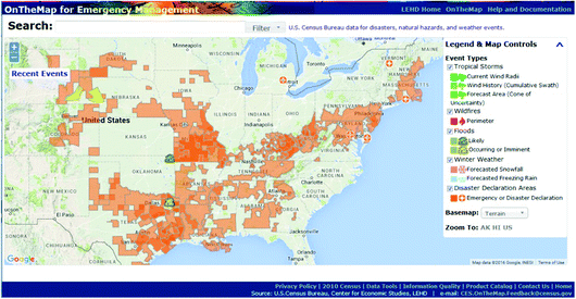
LEHD Application OnTheMap for Emergency Management (http://onthemap.ces.census.gov/em/)

4 Analysis
As contemporary incidents become more and more complex, responses to these incidents have begun to exceed the capacity of any one agency and require coordination with other agencies to interact together [18]. A lack of coordination across the numerous U.S. federal agencies charged with some aspect of EM led to the formation, in 1978, of the Federal Emergency Management Agency (FEMA). The 9/11 attack caused significant changes to the federal and national emergency response coordination with the new released NRP (National Response Plan). Then in the aftermath of Hurricane Sandy, NRP was replaced by NRF, which not only was the public sector saying governments need to interact but all across the society including NGOs, private sectors and citizens need to be involved in emergency preparedness and response. Now, the most important consideration when accidents happen is how to make all the stakeholders respond quickly and collaboratively on accurate, timely and distributed information.
4.1 Open Government Data Needs in Emergency Management
During emergencies stakeholders respond according to the information and directives they receive. The painfully slow response to Hurricane Katrina was a national embarrassment. The response state governments were waiting for were the federal directives to act and to provide funding and support to the area. However the federal agencies involved didn’t grasp the severity of situation immediately, which made the decision making slow, command vague and local governments response time insufficient. Further, government agencies, private sector companies and NGOs who might have been more responsive, knew little about the NRP. The public didn’t know the government’s rescue plan or evacuation schedule, nor the recovery plan for after the hurricane. There wasn’t a uniform platform for disseminating the information and directives so the multiple layers of government nor the public knew what happened and how to address and solve the problems from the disaster.
Hurricane Sandy in 2012 was another test for the new NRF. The results were considered much more effective than the Katrina response. All the agencies prepared for the hurricane landfall and communicated with each other, deployment of resources and logistics were found to be more efficient and effective. Communication among responding governments was improved though communication between government and the public such as citizens, private companies and NGOs remained problematic. However, the assessment also found that few people used shelters, the evacuation was inefficient, situational awareness was limited, and the recovery plan lacked public support.
The newly released NRF improved the sharing of information and directives among governments, though interaction between government and other stakeholders did not improve. The NRF was not open to other stakeholders to help inform their decision making and communication strategies, and as a consequence, little improvement was evident.
4.2 Open Government Data Leveraging in Emergency Management
When emergencies happen governments making decisions quickly and correctly and both the government and the public acting according to unified directives and collaborating immediately are the determinants of the emergency response. And all the systems should be prepared as emergency management’s main functions.
In the case of OnTheMap, firstly there is an unified platform based on the spatial geographic map which in the data publishing and data use phase it is published to the public via a wide variety of dissemination and analysis tools, and in the data collection phase it automatically incorporates real time data updates from the National Weather Service’s (NWS) National Hurricane Center, Department of Interior (DOI), Department of Agriculture (DOA), and FEMA. And all 50 states, the District of Columbia, Puerto Rico, and the U.S. Virgin Islands have joined the LEHD Partnership, although the LEHD program is not yet producing public-use statistics for Massachusetts, Puerto Rico, or the U.S. Virgin Islands.
For the widely use of data the LEHD program staff includes geographers, programmers, and economists. With the integrity of information about people, weather, hurricane landfall changes, transportation etc. are all available on this unified spatial geographic map, firstly both governments and the public become very aware to the accidents and its changes in time, then without panic the response could be better-organized; Secondly governments can make decisions very quickly according to the real time situation, such as response plan, evacuation plan, deployment plan and even the recovery plan with appropriate schedule; Thirdly the public can get the directive at the first time, and get to know the relief goods and rescue facilities immediately such as shelters locations, safe or dangerous buildings, which can help people from the second disaster; Finally if there are some applications developed using the open data on mobile phones which can actively push the updated emergency information to the citizens to let everybody get the information as soon as possible, and on the contrary the citizens can access some special information by themselves for example to find the nearest shelter location, or to find safety and a shortcut route to evacuate. Not only in the phase of response but in other phases open data can help emergency management become more efficient and accurate. In the above case of TRI, the company and its facilities using or releasing toxic chemicals are strictly monitored. The industrial standards could be set according to historic data to avoid toxic chemical accidents, governments’ supervision and administration can be based on data collected automatically instead of the data provided by the companies, which will be more reliable and respond quickly and accurately once accidents happen. To the public the data can be accessed easily which means they will know clearly where the dangerous locations are to be able to avoid themOpen data can be used to develop a “Toxic Chemical Maps” to help people far from the dangerous and also it will be very helpful for anybody to “monitor” the potential toxic chemical accidents happened.
5 Conclusion and Recommendation for Further Research
As incidents become more complex and severe, many more organizations are needed to as part of response efforts. Organizations tasked with addressing large scale events which affect many people and require significant resources are increasingly crossing traditional hierarchical boundaries to collaborate with other public, private, nonprofit organizations, and the media [19]. Multi-level, multi-sector, and cross-boundary information sharing is recognized as necessary for EM decision making.
The emergence of a new governance approach that combines the practices of traditional government with market driven approaches of the private sector and the resourcefulness of non-profit organizations is required. Coordination across the boundaries of government and non-governmental organizations, companies and citizens becomes a very important factor in the effectiveness of incident response.
As one important step toward more effective use of OGD in emergency management, Data.gov disseminates emergency preparedness information with the goal of helping the public prepare for many different kinds of incidents. Data such as that provided by LEHD, TRI and FGDC, are also resources for the public, in particular other governments, the private sector and NGOs, to produce applications that provide tools to visualize the data and visualizations themselves, for example, to support more rapid response by all stakeholders and improve the accuracy of decisions in routine emergency preparedness and response. Drawing on the experiences in the U.S. we propose a set of scenarios where the use of OGD in EM could be highlighted and cultivated to increase EM response capability.
-
During mitigation stage, the analysis of the routine data from production and business can help government locate the city’s vulnerability, and the usage of data will reflect the real production and business situation. Then governments can modified the industry standard or regulations to improve the city’s resilience;
-
During preparedness stage, preparedness will be more sufficient and well planned if government collects the updated data through a geographic platform like GeoPlatform.gov sharing geographic data, maps, and online services, the resources can be more efficiently reserved and shelters location can be more optimized according to the LEHD;
-
During response stage, rapid action and accurate decision-making are the most important things. Evacuation will be more efficient and well planned if government combine the dynamic Employer-Household data from LEHD and geographical data from federal or state’s geographic information center. And obviously it will be easier for the public to find the shelters if there is an application positioning nearest shelters via mobile phone;
-
During the recovery stage, quick and easy access to the recovery plan and accessibility to the emergency government agencies will improve the plans.
Hurricanes Katrina and Sandy were typical of recent city-based responses to disasters. Hurricane Katrina highlighted the lack of information sharing across levels of government and sectors and showed that such gaps in sharing contribute to slower and uncoordinated response and insufficient deployment of resources. The response to Hurricane Sandy was much more effective because of the lessons learned from Katrina about cross-boundary information sharing but problems still existed.
The conclusion that more complex and severe incidents require more coordination and information sharing across levels of government and functional agencies, as well as across sectors and with the public is well accepted. This conclusion makes it increasingly important to increase information sharing capability as part of EM. The unique and important opportunity of leveraging OGD in this regard requires continued attention and investment in ways that maximize value in the form of more effective and efficient emergency response efforts.
References
Lindsay, B.R.: Federal Emergency Management: A Brief Introduction. Congressional Research Service, 30 November 2012
Silva, T., Wuwongse, V., Sharma, H.N.: Disaster mitigation and preparedness using linked open data. J. Ambient Intell. Humaniz. Comput. 4, 591–602 (2013)
Janssen, M., Matheus, R., Zuiderwijk, A.: Big and open linked data (BOLD) to create smart cities and citizens: insights from smart energy and mobility cases. In: Tambouris, E., Janssen, M., Scholl, H.J., Wimmer, Maria A., Tarabanis, K., Gascó, M., Klievink, B., Lindgren, I., Parycek, P. (eds.) EGOV 2015. LNCS, vol. 9248, pp. 79–90. Springer, Cham (2015). doi:10.1007/978-3-319-22479-4_6
Olyazadeh, R., Aye, Z.C., Jaboyedoff, M., Derron, M.H.: Prototype of an open-source web-gis platform for rapid disaster impact assessment. Spat. Inf. Res. 24, 203–210 (2016)
Harrison, T.M., Guerrero, S., Burke, G.B., Cook, M., Cresswell, A., Helbig, N., Hrdinová, J., Pardo, T.: Open government and E-government: Democratic challenges from a public value perspective. In: Proceedings of the 12th Annual International Conference on Digital Government Research, New York, pp. 245–253 (2011)
Meijer, A., Bolívar, M.P.R.: Governing the smart city: a review of the literature on smart urban governance. Int. Rev. Adm. Sci. 82, 392–408 (2016)
The Global Facility for Disaster Recovery and Reduction (GFDRR). Open Data for Resilience Initiative. https://opendri.org/
Lehtomäki, J., Tuominen, S., Toivonen, T., Leinonen, A.: What data to use for forest conservation planning? A comparison of coarse open and detailed proprietary forest inventory data in Finland (2015)
Badawi, O., Brennan, T., Zimolzak, A., et al.: Making big data useful for health care: a summary of the inaugural MIT critical data conference. J. Med. Internet Res. (2014)
Bui, T., Pham, H.: Web-Based GIS for Spatial Pattern Detection: Application to Malaria Incidence in Vietnam. Springer, Cham (2016). doi:10.1186/s40064-016-2518-5
Consoli, S., Gangemi, A., Nuzzolese, A.G., Peroni, S., Reforgiato Recupero, D., Spampinato, D.: Setting the course of emergency vehicle routing using geolinked open data for the municipality of Catania. In: Presutti, V., Blomqvist, E., Troncy, R., Sack, H., Papadakis, I., Tordai, A. (eds.) ESWC 2014. LNCS, vol. 8798, pp. 42–53. Springer, Cham (2014). doi:10.1007/978-3-319-11955-7_4
Balbo, S., Boccardo, P., Dalmasso, S., et al.: A public platform for geospatial data sharing for disaster. Risk Manag. 1(5), 189–195 (2013)
U.S. Department of HomeLand Security, National Response Framework (2008)
Homeland Security Presidential Directive-5: Management of Domestic Incidents (2003)
Web. https://www.epa.gov/toxics-release-inventory-tri-program
Wise, C.R., Nader, R.: Organizing the federal system for homeland security: problems, issues, and dilemmas. Public Adm. Rev. 62, 44–57 (2002)
Kapucu, N.: Examining the National Response Plan in response to a catastrophic disaster: Hurricane Katrina in 2005. Public Adm. Rev.
Acknowledgements
The work is supported by Natural Science Foundation of Guangdong Province China (Grant No. 2015A030313315), the Fundamental Research Funds for the Central Universities (Grant No. 15JNKY002), Social Science Foundation of China Major Project (Grant No. 14ZDB166), and the Guangzhou City Construction of State-level Scientific Research Think Tank (Grant No. 2016SX013).
Author information
Authors and Affiliations
Corresponding author
Editor information
Editors and Affiliations
Rights and permissions
Copyright information
© 2017 IFIP International Federation for Information Processing
About this paper
Cite this paper
Chen, Y., Pardo, T.A., Chen, S. (2017). Exploring on the Role of Open Government Data in Emergency Management. In: Janssen, M., et al. Electronic Government. EGOV 2017. Lecture Notes in Computer Science(), vol 10428. Springer, Cham. https://doi.org/10.1007/978-3-319-64677-0_25
Download citation
DOI: https://doi.org/10.1007/978-3-319-64677-0_25
Published:
Publisher Name: Springer, Cham
Print ISBN: 978-3-319-64676-3
Online ISBN: 978-3-319-64677-0
eBook Packages: Computer ScienceComputer Science (R0)