
Abstract
The implementation of early warning systems is in line with the Sendai Framework for Disaster Risk Reduction (SFDRR) 2015–2030. One of the four priorities of the Sendai Framework for Action emphasizes the improvement of preparedness in response to a disaster by carrying out a simple, low-cost early warning system and improving its dissemination. A new proposal of a standard for community-based landslide early warning systems has been promoted to the International Organization for Standardization (ISO) by Universitas Gadjah Mada, in corporation with the Indonesian Standardization Agency and the Disaster Management Authority. The standard will serve to empower individuals and communities who are vulnerable to landslides to act in sufficient time in appropriate ways to reduce the possibility of injuries, loss of life and damage to property and the environment. It is designed to encourage communities to play a much more active role in their own protection. The guidelines adopted the concept of people-centered early warning system by UN-ISDR (Developing an early warning system: a checklist. Bonn, Germany, 2006) and will be used by communities vulnerable to landslides, and by government agencies and non-governmental organizations at central, provincial, municipality/district, sub-district, and village levels. The recommendations include: (1) Risk assessment; (2) Dissemination and communication; (3) Formation of disaster preparedness and response teams; (4) Development of evacuation maps; (5) Development of standard operating procedures; (6) Monitoring, early warning, and evacuation drills; (7) Commitment of the local authority and community to maintain the system. The standard will be developed by ISO/TC 292 Security and resilience, with the participation of 43 countries in the committee’s work and another 14 as observers. The basic concept of this global standard has been initiated since 2007 through the Asian Joint Research on Early Warning of Landslides proposed by International Consortium on Landslides (ICL) and Disaster Prevention Research Institute (DPRI) Kyoto University and funded by JST and implemented in Indonesia, China, Korea and Japan. This paper describes the achievements and the current activities of the World Centre of Excellence (WCoE) on Landslide Risk Reduction (2014–2017), IPL Project (IPL-158) “Development of community-based landslide early warning system”, and IPL Project (IPL-165) “Development of community-based landslide hazard mapping for landslide risk reduction at the village scale in Java, Indonesia”.
You have full access to this open access chapter, Download conference paper PDF
Keywords
Introduction
Landslides occur in different topographic and geologic settings and cause great social and economic losses. Landslide occurrence may increase due to human expansion into unstable hill-slope areas. Landslide mitigation efforts may be carried out both structurally and non-structurally. Structural mitigation includes the arrangement of slope geometry, reinforcement and protection of slopes, and improvement of drainage systems, all of which would incur a high cost. Meanwhile, relocation usually is not possible for residents living in areas prone to landslides. Under these conditions, the most effective disaster risk reduction effort is non-structural mitigation through the improvement of the community’s preparedness by implementing early warning systems.
Currently many countries already have landslide and debris flow early warning systems (Baum and Godt 2009), including Indonesia (Fathani et al. 2014). The implementation of early warning systems is in line with the Sendai Framework for Disaster Risk Reduction (SFDRR) 2015–2030, with four priorities in disaster risk reduction. The fourth priority emphasizes the improvement of preparedness to respond effectively to a disaster by implementing a simple, low-cost early warning system and improving the dissemination of information about early warning signs of natural disasters at local and national levels.
According to UN-ISDR (2006), a complete and effective early warning system is composed of four interrelated key elements, i.e., (1) risk knowledge, (2) monitoring and warning service, (3) dissemination and communication, and (4) response capability. The implementation of a community-based early warning system must take into account the correlation between a strong bond and effective communication channels among all of these elements. The goal of the development of people-centered early warning system is to empower individuals and communities vulnerable to hazards to act in sufficient time and in appropriate ways to reduce the possibility of injuries, loss of life, and damage to properties and the environment.
Demographic, social, economic, and cultural aspects in general are often left out in the implementation of early warning systems, compared to other technical aspects (Karnawati et al. 2011). The experts, researchers, and the decision-makers at regional, national, provincial, municipality/district or village levels should follow up the training in warnings and actions to be taken addressed for the community. Consequently, early warning system guidelines encourage the roles of the community and social aspects.
Referring to the four key elements of people-centered early warning systems (UN-ISDR 2006), it is crucial to develop a global standard for landslide early warning systems to have uniformity in the effort to carry out early warning systems and improve the preparedness of the community and related stakeholders in landslides prone areas.
Standard for Landslide Early Warnings
This proposed standard specifies the requirements for a landslide early warning system, which include the definition, understanding, stage of procedures, implementation, as well as types of activities. This standard should be used by government agencies and non-governmental organizations, at central, provincial, municipality/district, sub-district, and village levels, and by communities vulnerable to landslides.
The community-based landslide early warning system was derived from four key elements of people-centered early warning system (UN-ISDR 2006) and constitutes of seven main sub-systems as elaborated below (Fathani et al. 2016):
-
1.
Risk assessment;
-
2.
Dissemination and communication;
-
3.
Establishment of disaster preparedness and response teams;
-
4.
Development of evacuation routes and maps;
-
5.
Development of standard operating procedures;
-
6.
Monitoring, early warning, and evacuation drills;
-
7.
Commitment of the local government and community to the operation and maintenance of the whole system.
The components of the seven sub-systems of the community-based landslide early warning system are elaborated in this following section.
Risk Assessment
Risk assessment is carried out with technical (geomorphology, geology, and geotechnics), institutional, and social-economy-cultural surveys of vulnerable communities. Technical surveys are conducted to understand the geological conditions in certain areas, especially to determine landslide susceptibility and stable zones (Lacasse and Nadim 2009). The survey is also carried out to collect data regarding mass movement, such as cracks and subsidence, appearance of springs, fractures in structures, and tilting of poles and trees, to figure the placement of the landslide early warning instruments. During the technical survey, information on lithology types and distribution, slope soil composition, geological structure types and their orientation distribution, slope cracks, and slope inclination should also be included.
An institutional survey is carried out to find out if there is an institution to monitor and mitigate landslide hazards in a disaster-prone area. Meanwhile, a cultural-economic survey is performed to collect data on the demographics of the community, such as population (household), age, education, financial situation (vehicles and livestock), and culture. Information on potentially vulnerable inhabitants and infrastructure is important to determine the risk level in a certain area.
A social survey is performed to figure the community’s perception of landslide risks and landslide disaster risk reduction efforts and applied technology. As a prerequisite for formulating strategies for risk reduction programs suitable for the local social conditions, the community must be eager and motivated to actively participate in the program. Therefore, it is critical to increase people’s awareness; and training and education are two of the programs to increase people’s awareness. This activity imparts knowledge and increases people’s capability to decide the actions to prevent landslides and protect themselves from landslides.
Dissemination and Communication
Dissemination aims to impart knowledge and understanding to the community, particularly for landslide disasters, and to understand the community’s aspirations. Methods and materials to aid in dissemination are tailored to the performed preliminary data of the risk assessments. This understanding includes landslide definition, their types, mechanisms of occurrence, factors controlling and triggering them, signs, and both structural and non-structural mitigation of landslides, including early warning systems, warning levels, and signs. The dissemination and communication increases the community understanding about landslides, ranging from the mechanisms and the signs, to how to minimize risks, especially with the early warning system to be installed. In addition, it is necessary to determine the key people with a strong commitment as initiators in the formation of a disaster preparedness team.
Establishment of Disaster Preparedness and Response Team
A disaster preparedness and response team is formed based on the community meetings facilitated by the government or related agencies. The appointment of the team is based on the abilities of the member in preparedness, prevention, mitigation, and post-disaster management of landslide disaster. The team (at least) consists of a chairperson, data and information division, evacuee mobilization division, first aid division, logistics division, and security division (Fig. 1). The number of divisions in the disaster preparedness and response team is determined based on the needs of the community and should be in agreement with the purpose of early warning systems. Each division comprises 3 people at the minimum or in proportion to its population. Each division should consist of a chief and members who are aware of and responsible for their duties. Moreover, the division should be comprised of the people living at the location where the early warning system is placed. An example of a disaster preparedness and response team is shown in Fig. 1.

Proposed structure of disaster preparedness team
The disaster preparedness and response team is tasked with conducting all activities related to preparedness, such as organizing the community to support the technical system effectively. The team is responsible for deciding landslide risk zones and evacuation routes that are verified by the local authority or institution officials or experts, and arrange the people to evacuate before the landslide hits. The disaster preparedness and response team is in charge of operating and maintaining monitoring tools and the landslide early warning system that has been installed.
Development of an Evacuation Map
An evacuation map includes landslide risk zones and evacuation routes, which provide information on the zones that are safe or unsafe during a landslide emergency, safe evacuation routes for the residents to evacuate and secure locations for assembly points (Fig. 2). The disaster preparedness team, community, and stakeholders uses the landslide risk zones and evacuation routes as the operational guidelines to gather at the assembly point and subsequently evacuate by following the evacuation route that has been determined. The zones are created by the disaster preparedness team who have gained a basic knowledge of communication, and have been verified by experts. The map/ground plan provides the following information (as suggested by Karnawati et al. 2013b; Fathani et al. 2016):

Example of an evacuation route map installed at a village prone to landslides
-
(a)
High-risk and low-risk (safe) zones;
-
(b)
Homes, which include the homeowners;
-
(c)
Important facilities: school, places of worship, community health center, offices, and landmarks;
-
(d)
Streets and alleys;
-
(e)
Installation point of early warning system;
-
(f)
Alert post;
-
(g)
Evacuation routes;
-
(h)
Assembly Points;
-
(i)
Refugee camps.
Development of Standard Operating Procedures (SOP)
Standard operating procedures (SOP) serve as a guide for the disaster preparedness team and the community when facing all hazard levels, i.e., Caution (Level 1), Warning (Level 2), and Evacuate (Level 3). The SOP contains the procedures for responses by the disaster preparedness team and the community to the alert issued by the control center in the field or by local authorities (Table 1). The SOP is developed in regards to the discussions of each division and based on the direction of relevant stakeholders to follow the flow of warning information delivery mechanisms and evacuation commands.
Monitoring, Early Warning and Evacuation Drill
Early detection devices are placed in areas that have the highest risk and the greatest number of affected population. Determination of the locations is based on the identification of landslide risk zones. Installation of the equipment is done with the community, aiming to increase the sense of ownership and responsibility for the equipment’s condition to guarantee people’s safety. The type of early detection and danger levels should be appropriate to the geological conditions and the size of the territory. The monitoring devices that must be installed to support early warning systems are:
-
(a)
rain gauge: to measure the intensity of rainfall within a certain period.
-
(b)
surface deformation instruments: to monitor the deformation on the land surface in a certain period. The common devices used are extensometers (to monitor the relative distance between two points on the crack) as shown in Fig. 3 and tiltmeters (to measure the change of slope inclination)
Fig. 3 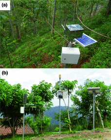
Example of monitoring and warning devices: a extensometer; b rain gauge and local server

To improve measurement accuracy, additional devices can be used, as follows:
-
(a)
underground deformation meter: to measure the deformation through the movement of the sliding plane within a certain period of time (inclinometer, pipe strain gauge, multi-layer movement meter, etc.).
-
(b)
groundwater level meter: to measure changes in groundwater level in the landslide zones, mounted inside the borehole.
-
(c)
pore water pressure sensor: to measure changes in pore water pressure in the land mass, installed in the borehole.
-
(d)
soil moisture sensor: to measure the changes of water level in the land mass.
-
(e)
survey stake: to monitor mass movement by using wooden sticks or bamboo.
The monitoring and early detection devices should utilize effective technology to deliver a community-based landslide early warning system. The technology is in the form of a radar monitoring module or conventional monitoring module i.e., in situ geotechnical instrumentation (Barla and Antolini 2015). The minimum landslide early warning devices to be installed are the mass movement gauge and rain gauge (Fig. 3). The landslide monitoring and early warning scheme are shown in Fig. 4.

Scheme of landslide monitoring and early warning system (Fathani et al. 2016)
After the devices are placed, the disaster preparedness team is established, the evacuation routes are determined, and the evacuation SOP is developed, an evacuation drill to ensure the functionality of the devices and the community’s responses to anticipate disaster is carried out. The drill is conducted using a SOP-based scenario. It serves to instill vigilance, preparedness, and responsibility in the disaster preparedness team when the devices show the indication of a potential landslide. Furthermore, the evacuation drill is also aimed at introducing and familiarizing the local community with the sound of sirens of every early detection device, and familiarizing them with evacuation in emergency situations. The evacuation drill must be conducted at least once a year at the end of the dry season.
Commitment of the Local Government and Community to the Operation and Maintenance of the System
To ensure that all stages in the SOP is run well, the commitment of the local government and the community is vital for the operation and maintenance of the system. The government, the community, and the private sector must acknowledge the duty and responsibility including the ownership, installation, operation, maintenance, and security of the early warning system that are adjusted to the conditions of each location.
Discussions
The global standard includes one of the priorities of Sendai Framework for Disaster Risk Reduction (SFDRR) 2015–2030, which is described in four elements of a people-centered early warning system. The elements are then developed into seven sub-systems of a landslide early warning system. To assist the implementation of landslide early warning systems in Indonesia where the trial of this standard has been conducted, a hybrid socio-technical approach is carried out. Both approaches (technical and social), supported with education and research, are expected to be able to involve all of the related stakeholders, reduce the cost of system implementation, and maintain its sustainability (Karnawati et al. 2011, 2013a). The monitoring and warning service equipment installed in 20 provinces since 2012 is still in excellent condition due to the implementation of the above proposed methods. The description above shows that the proposed methodology or standard is successfully implemented in Indonesia.
The primary issue that the implementation of this system tries to address is that the implementation of only the technical approach is not effective for sustainable disaster prevention. This is often the case when the local authority/third party installs early warning system devices without involving local community. As a consequence, the community does not have a proper response capacity when the devices are triggered. The establishment and implementation of the seven sub-systems as a global standard for landslide-prone countries will support the disaster risk reduction effort. Moreover, with community involvement, the operation, maintenance, and sustainability of an entire system are secured early. At the end of 2015, this proposed standard is being nominated as an international standard for landslide early warning systems by ISO/TC 292 Security and resilience.
References
Barla M, Antolini F (2015) An integrated methodology for landslides’ early warning systems. Landslides 13: Springer, Berlin, Heidelberg
Baum RL, Godt JW (2009) Early warning of rainfall-induced shallow landslides and debris flow in the USA. Landslides 7: Springer, Berlin, Heidelberg
Fathani TF, Karnawati D, Wilopo W (2016) An integrated methodology to develop a standard for landslide early warning system. J Nat Hazards Earth Sys Sci. doi:10.5194/nhess-2016-209
Fathani TF, Karnawati D, Wilopo W (2014) An adaptive and sustained landslide monitoring and early warning system. Landslide Science for a Safer Geoenvironment. Springer International Publishing, pp 563–567
Karnawati D, Fathani TF, Wilopo W, Setianto A, Andayani B (2011) Promoting the hybrid socio-technical approach for effective disaster risk reduction in developing countries. In: Brebbia CA, Kassab AJ, Divo EA (eds) Disaster management and human health risk II. WIT Press, Southampton, UK, pp 175–182
Karnawati D, Ma’arif S, Fathani TF, Wilopo W (2013a) Development of socio-technical approach for landslide mitigation and risk reduction program in Indonesia. ASEAN Eng J Part C 21(7):22–47
Karnawati D, Fathani TF, Wilopo W, Andayani B (2013b) Community hazard map for landslide risk reduction. ICL Landslide Teaching Tools. International Consortium on Landslides, pp 259–266
Lacasse S, Nadim F (2009) Landslide risk assessment and mitigation strategy. In: Sassa K, Canuti P (eds) Landslides-disaster risk reduction. Springer, Berlin, Heidelberg, pp 31–61
UN-ISDR (2006) Developing an early warning system: a checklist. The Third International Conference on Early Warning (EWC III). Bonn, Germany
Acknowledgements
The authors gratefully acknowledge the International Consortium on Landslides (ICL) and Disaster Prevention Research Institute (DPRI) Kyoto University for initiating the Asian Joint Research on Early Warning of Landslides, which is funded by JST and has been implemented in Indonesia, China, Korea and Japan. We acknowledge the Indonesian National Disaster Management Authority (BNPB) and the National Standardization Agency of Indonesia (BSN) for supporting and promoting this global standard to the International Organization for Standardization: ISO/TC 292, Security and resilience and for the participating countries and observers during the establishment of this new standard.
Author information
Authors and Affiliations
Corresponding author
Editor information
Editors and Affiliations
Rights and permissions
This chapter is published under an open access license. Please check the 'Copyright Information' section either on this page or in the PDF for details of this license and what re-use is permitted. If your intended use exceeds what is permitted by the license or if you are unable to locate the licence and re-use information, please contact the Rights and Permissions team.
Copyright information
© 2017 The Author(s)
About this paper
Cite this paper
Fathani, T.F., Karnawati, D., Wilopo, W. (2017). Promoting a Global Standard for Community-Based Landslide Early Warning Systems (WCoE 2014–2017, IPL-158, IPL-165) .
In: Sassa, K., Mikoš, M., Yin, Y. (eds) Advancing Culture of Living with Landslides. WLF 2017. Springer, Cham. https://doi.org/10.1007/978-3-319-59469-9_30
.
In: Sassa, K., Mikoš, M., Yin, Y. (eds) Advancing Culture of Living with Landslides. WLF 2017. Springer, Cham. https://doi.org/10.1007/978-3-319-59469-9_30
Download citation
DOI: https://doi.org/10.1007/978-3-319-59469-9_30
Published:
Publisher Name: Springer, Cham
Print ISBN: 978-3-319-53500-5
Online ISBN: 978-3-319-59469-9
eBook Packages: Earth and Environmental ScienceEarth and Environmental Science (R0)