
Abstract
This paper discusses British military mapping in South Africa by initially reviewing the early military cartography based on existing Dutch maps, and the cartography resulting from the shift of the centre of military gravity from Cape Town to the Eastern Frontier. Attention is subsequently given to the cartography which emanated from the various “small wars” or skirmishes which took place in the Orange Free State (1848), Basutoland (1868), Sekhukhuniland (1868), Zululand (1879), Bechuanaland (1885), and the Transvaal (1880–1881) during the half a century it took Britain to decide whether it wanted to be a permanent player in southern Africa. The British Army’s response to the challenge to provide in the huge demand for maps created by the Boer War (1899–1902) is dealt with in some detail and, to conclude, the change in the mapping policy of the War Office towards Britain’s colonies after the War is discussed with reference to the level of mapping in southern Africa south of the Limpopo by 1914.
Access this chapter
Tax calculation will be finalised at checkout
Purchases are for personal use only
Notes
- 1.
Arrowsmith, A (1805) To Captain Carmichael Smyth of the Corps of Royal Engineers..., this Chart of the Cape of Good Hope is inscribed by his obedient and most humble servant, A. Arrowsmith. London: A. Arrowsmith. 4 sheets, each 71 x 61 cm.
- 2.
Examples are (a) British National Archives (hereafter BNA), MPHH 522. Cape of Good Hope. MS map of Cape Peninsula, signed by G. Bridges, Capt. RE, 1899. Also in Barrow, J. 1801; (b) BNA, MPH 697. MS Coast of Africa from Table Bay at the Cape of Good Hope to Saldanha Bay. Size 71 x 26 cm; (c) BNA, MR 1293. MS Plan of the Southern Coast of Africa between St Helena and Algoa Bays. Signed by Henry Smart, Capt RE, 1815. Size 148 x 81 cm; (d) BNA, MR 457. MS Plan of the Town and Fortifications at the Cape of Good Hope. Signed by G. Bridges, Capt RE, 1798. Size 86 x 82 cm.
- 3.
Cape Archival Repository (hereafter CAR), CO 165, “Extracts of a Dispatch….”, Donkin to Bathurst, 15 June 1821.
- 4.
CAR, GH 1/56, General Despatches: Hill to Officer Commanding at the Cape of Good Hope, 30 June 1826, no. 801, p. 63.
- 5.
CAR, M2/133 (sketch no 1), M2/134 (sketch no 2), M3/90 (sketch no 3), M2/135 (sketch no 6); Garson 1992. Versatile Genius, The Royal Engineers and their maps. Johannesburg: Library of the University of the Witwatersrand. See Map 4 (sketch no 4) and Map 3 (sketch no 7).
- 6.
CAR, M3/88. MS Plan of the North Eastern Frontier of the Cape of Good Hope.
- 7.
CAR, CO 403, Michell to Bell, 6 December 1832. Enclosure to Despatch no. 32 of 20 Dec 1832.
- 8.
Arrowsmith, J. (1848) Eastern Frontier of the Colony of the Cape of Good Hope (and part of Kafirland), from Algoa Bay, to the Great Kei River chiefly from MSS Surveys and Sketches communicated by Lt Col Michell, Surv r. Gen l. of the Colony Pub d. 4th June 1848. Size 49 x 60 cm. London: Arrowsmith.
- 9.
Hall, H (1856). Map of the Eastern Frontier of the Cape Colony, compiled by Henry Hall, from military and other surveys, dedicated by permission to Lt. Gen. Sir I F Burgoyne, KCB. Size 96 x 101 cm. London: Edward Stanford.
- 10.
Bell, Charles D. (1851). “Sketch map of the Sovereignty beyond the Orange River, and a supplementary map of South Africa”, in British Parliamentary Papers, Colonies Africa 36, 1851. Lithographed by J. Arrowsmith. Size 50 x 55 cm.
- 11.
Map of Basutoland and adjacent territories. Compiled at the Intelligence Dept. Horse Guards from the latest information obtained from the Surveyor General Cape Colony, the Resident Magistrates & other available sources. November 1880. Scale 1:633,600. Size 58 x 59 cm.
- 12.
Map IDWO 739, Map of Basutoland. Compiled at the Intelligence Division, War Office from all the available sources together with information supplied by Lt. Col. Sir Marshall Clarke KCMG, HM Commissioner for Basutoland, 1888. Revised 1892. Scale 1:380,160. Size 66 x 94 cm.
- 13.
Warren, C. Map of Griqualand West and adjoining districts. Compiled from the Survey of Eastern Boundary by Lieut. Colonel C. Warren C.M.G. Royal Engineers, the itineraries of Capt HME Brunker twenty-sixth Regt and other sources. August 1879. Compiled & Lithographed at the Intelligence Branch Qr Mr Genls Dept 1879. Scale 1:633,600. Size 56 x 63 cm.
- 14.
For a list of the sketch maps of Sekhukuni’s Territory by the Intelligence Branch Qr Mr Genls Dept Horse Guards, see Jewitt, A C (2011), op cit., 301.
- 15.
Map IDWO 11, Part of the Transvaal embracing the country between Pretoria, Standerton, Rustenburg and Potchefstroom. Compiled in the Intelligence Dept, March 1881. Scale 1:633,600. Size 29 x 35 cm.
- 16.
Grantham, J (1863) Map of the Colony of Natal. Surveyed by Captain Grantham, RE, FRGS, Assoc. In CE &c.in 1861 with additions from the Surveyor General’s Office Natal. Lithographed at the Topographical Department of the War Office, 1863. Scale 4 miles per inch.
- 17.
Examples are (a) Map of Zululand. Compiled at the Intelligence Dept, Horse Guards, from the Military Trigonometrical Surveys and the various Topographical Sketches made by Officers during the Campaign of 1879. Scale 1:253,440 or 4 miles to 1 inch. 2 sheets. Compiled and Lithographed May 1881; revised July 1885. (b) Military Map of Zululand compiled from most recent information. Intelligence Branch Qr Mr Genls Dept. Scale 1:31,668 or 5 miles to 1 inch. March 1879. Size 64 x 87 cm. For a list of sketch maps pertaining to different areas of Zululand, see Jewitt, A C (2011), op cit., 372–373.
- 18.
Map IDWO 502–517. 1886. Map of Bechuanaland. Scale 1:126,720. 14 sheets, each 88 x 52 cm. The sheets are designated IDWO 504–517 and numbered respectively Sheet 1–14.
- 19.
Map IDWO 1223. 1897. Military sketch of the Biggarsberg and of communications in Natal north of the parallel of Ladysmith. Scale 1:63,360. London: Intelligence Department, War Office. 19 sheets, each 59 x 67 cm.
- 20.
Map IDWO 1367. 1899–1900. Transvaal and Orange Free State. Scale 1:250,000 London: Intelligence Department, War Office. 28 sheets, each 70 x 82 cm.
- 21.
GSGS 1764. 1906–1914. Reconnaissance series of the Cape Colony and Basutoland. 33 sheets, each 65 x 61 cm. London: War Office, Geographical Section, General Staff. Scale 1:250,000.
- 22.
GSGS 2618. 1913. Topographical survey of the Transvaal. 8 sheets, each 65 x 61 cm. London: Geographical Section, General Staff. Scale 1:125,000.
Fig. 17 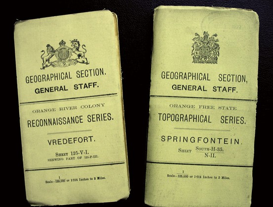
Examples of folded GSGS 2230 maps
Fig. 18 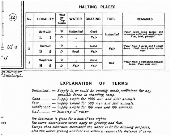
Information in the margin of a GSGS 1764 sheet on the availability of water and grazing
Fig. 19 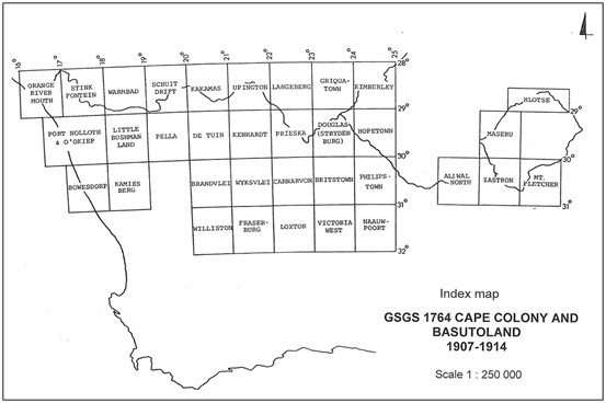
Index map of GSGS 1764 of the Cape Colony and Basutoland 1905–1911


References
Amery LS (ed) (1909) The Amery LS (ed) (1909) The Times’ History of the War in South Africa, 1899–1902, vol. 6. Sampson Low Marston & Co., London
Bergh JS, Visagie JC (1985) The Eastern Cape frontier zone 1660–1980. Butterworths, Durban
Board C (2004) The Imperial Map Cape Colony towards a cartobibliography. In: Kainz W, Kriz K, Riedl A (eds) Wiener Schriften zur Geographie und Kartographie 16, 17–24. University of Vienna, Vienna
Board C (2009) The style sheet for the War Office series GSGS 1764, Cape Colony Reconnaissance. In: Proceedings of the symposium on the history of cartography, Portsmouth University, International Cartographic Association, Pretoria. 10–12 Sep 2008
Close CF (1933) A fifty years retrospect. Empire Surv Rev 2(7):2–6
Colonial Office (1907) Minutes of the Meeting of 14.8.1905, in Confidential Correspondence Relating to the Survey of British Colonies and Protectorates in Africa, Memorandum 23771, no. 1. London
Farwell B (1972) Queen Victoria’s Little Wars. Harper & Row, New York
Fergusson TG (1984) British Military Intelligence. Arms & Armour Press, London, 1870–1914
Garson Y (1992) Versatile Genius, The Royal Engineers and their maps. Library of the University of the Witwatersrand, Johannesburg
Jackson Brevet-Lieutenant-Colonel HM and Casgrain, Captain PH du P (1902) Reports on Survey and Mapping Sections in South Africa. Ministry of Defense, Whitehall Library, S.A. 490/A to J, London
Jewitt AC (1992) Maps for Empire. The First 2000 War office Maps. British Library, London
Jewitt AC (2011) Intelligence Revealed. Maps, Plans and Views at Horse Guards and the War Office, 1800–1880. British Library, London
Koeman C (1952) Tabula Geographicae & c. Eighteenth century cartography of the Cape Colony. NV Hollandsch-Afrikaansche Uitgevers, Cape Town
Koeman C (1988) Nieuwe bijdragen tot de kennis van Zuid-Afrika’s historische kartografie. In: Schilder G, van der Krogt P (eds) Miscellanea Cartographica. HES, Utrecht
Laband J (2005) The Transvaal Rebellion. The First Boer War 1880–1881. Pearson Longman, Harlow UK
Liebenberg EC (1973) Die topografiese kartering van Suid-Afrika. Unpublished M.A. thesis, University of South Africa
Liebenberg E (1997) Mapping British South Africa: the case of GSGS 2230. Imago Mundi 49:129–142
Liebenberg E (2014) The Major Jackson’s Transvaal and Natal series of the Anglo-Boer War (1899–1902): a cartobibliographic framework. In: Liebenberg E, Collier C, Török ZG (eds) History of cartography. International symposium of the ICA, 2012. Springer, Heidelberg
Royal Commission on the War in South Africa (1903a) Report of His Majesty’s commissioners appointed to inquire into the military preparations and other matters connected with the War in South Africa. Bluebook Cd 1789. HMSO, London
Royal Commission on the War in South Africa (1903b) Minutes of Evidence, vol. I. Bluebook Cd 1790. HMSO, London
Scottish Geographical Society (1885) Scottish Geographical Magazine, vol 1, Edinburgh
Surveyor General (Transvaal) (1920) Annual Report of the Surveyor General 1920. Unpublished typescript document, Pretoria
Topographic survey of South Africa. Proceedings of Congress held at Cape Town, March, 1904. Government publication G 77–1904. Cape Times, Cape Town
Webb DA (1998) Fortifications in the Province of Queen Adelaide and British Kaffraria 1835–1866. Castle Military Museum, Cape Town
Winterbotham HSL (1936) Mapping of the Colonial Empire. Scot Geogr Mag 52(5), 289–299
Author information
Authors and Affiliations
Corresponding author
Editor information
Editors and Affiliations
Rights and permissions
Copyright information
© 2016 Springer International Publishing Switzerland
About this paper
Cite this paper
Liebenberg, E. (2016). Mapping for Empire: British Military Mapping in South Africa, 1806–1914. In: Liebenberg, E., Demhardt, I., Vervust, S. (eds) History of Military Cartography. Lecture Notes in Geoinformation and Cartography(). Springer, Cham. https://doi.org/10.1007/978-3-319-25244-5_15
Download citation
DOI: https://doi.org/10.1007/978-3-319-25244-5_15
Published:
Publisher Name: Springer, Cham
Print ISBN: 978-3-319-25242-1
Online ISBN: 978-3-319-25244-5
eBook Packages: Earth and Environmental ScienceEarth and Environmental Science (R0)