
Abstract
Cartograms are one of the youngest methods of representation in thematic cartography. Their origins can be dated to the first years of the 20th century, but the first cartogram-like representations were made in the second half of the 19th century. A very interesting detail is that the first cartograms were created to be specifically published in newspapers or journals destined for the public in general, as well as for publications related to school cartography. During the second half of the 20th century the development of cartograms decreased and their use in publications related to education can be considered all but nil, for various reasons that are analysed in this study. In the last 25 years we have witnessed the rebirth of cartograms, in many cases using the latest web-based interactive technologies for their publication. This chapter also provides recommendations for the possible use of cartograms to illustrate and support teachers’ explanations in classrooms.
Access this chapter
Tax calculation will be finalised at checkout
Purchases are for personal use only
Preview
Unable to display preview. Download preview PDF.
References
Dorling D (1991) The Visualization of Spatial Structure. Dissertation, University of Newcastle upon Tyne.
Dorling D (1996) Area cartograms: their use and creation (CATMOG 59).http://qmrg.org.uk/files/2008/11/59-area-cartograms.pdf. Accessed 12 December 2013
Dorling D, Barford A and Newman M (2006) Worldmapper: the world as you’ve never seen it before. http://www.dannydorling.org/wp-content/files/dannydorling_publication_id0892.pdf. Accessed 18 February 2014
Fabrikant S-I (2003). Commentary on “A History of Twentieth-Century American Academic Cartography” by Robert Mc Master and Susanna McMaster. Cartography and Geographic Information Science (CAGIS), 30(1), pp. 81-84.
Freytag-Berndt (1998) Unterstufen-Schulatlas. Freytag-Berndt, Wien.
Florisson S, van Kreveld M. and Speckmann B (2005) Rectangular Cartograms: Construction & Animation.http://www.win.tue.nl/~speckman/papers/CartoAnim.pdf.Accessed 20 December 2013
Gastner M-T and Newman M-E-J (2004) Diffusion-based method for producing densityequalizing maps. In: Proceedings of the National Academy of Sciences of the United States of America (PNAS), 101(20). Available via PNAS website. http://www.pnas.org/content/101/20/7499.full.pdf. Accessed 12 December 2013
Gießmann S (2013) Henry Charles Beck, material culture and the London Tube Map of 1933. http://amodern.net/article/henry-c-beck-material-culture-and-the-london-tube-map-of-1933. Accessed 18 February 2014
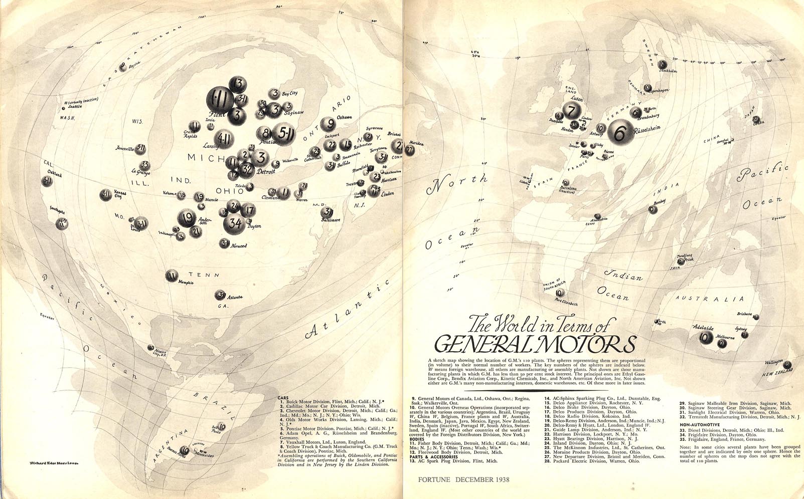
Harrison R-E (1938) The world in terms of General Motors. In: Fortune magazine [online]. http://www.fulltable.com/vts/f/fortune/aac/0d5.jpg. Accessed 20 December 2013
Kaspar S, Fabrikant S-I and Freckmann P (2011) Empirical study of cartograms. http://www.geo.uzh.ch/~sara/pubs/kaspar_fabrikant_freckmann_ica11.pdf. Accessed 20 December 2013
Krygier J (2008)1911 Cartogram: “Apportionment Map”. Available via Making Maps: DIY Cartography website. http://makingmaps.net/2008/02/19/1911-cartogram-apportionment-map/. Accessed 11 December 2013
Levasseur P-É (1875) La France, avec ses Colonies. Contenant 174 cartes, coupes et figures explicativesinséréesdans le texte. https://archive.org/details/lafranceavecsesc00leva. Accessed 12 December 2013
McNally R (ed) (1897) Indexed Atlas of the World. Rand McNally& Co, Chicago
Olney J (1837) A new and improved school atlas, to accompany the practical system of modern geography. Robinson, Pratt & Co, New York
Pelkofer T (1996) Using cartograms to learn about Latin American demographics. http://laii.unm.edu/outreach/common/retanet/science_math/RETANET_Lesson-Plan_Using-Cartograms.pdf. Accessed 15 December 2013
Philip G. (ed) (1979) Atlas of Canada and the World. George Philip and Son, Milwaukee
Raisz E (1934) The rectangular statistical cartogram. Geographical Review 24(2):292-296
Raisz E (1944) Atlas of Global Geography. Global Press Corp, New York
Raisz E (1948) General Cartography. 2nd ed. McGraw-Hill, New York
Raisz E (1962) Principles of Cartography. McGraw-Hill, New York
RGS-IBG (2013) KS3 Tutorial: Population and Migration. http://www.rgs.org/NR/rdonlyres/F7B60E25-E130-4E7E-B21B-6A32B25740C5/0/KS3_CPD_PopulationandMigration_script.pdf. Accessed 20 December 2013
Singh Y-K (2007) Instructional technology in education. APH Publishing Corporation, New Delhi
Slocum T-A, McMaster R-B, Kessler F-C and Howard H-H (2005) Thematic Cartography and Geographic Visualization. 2nd ed. Pearson Prentice Hall, Upper Saddle River
Thrower N-J-W (2008) Maps and Civilization: Cartography in Culture and Society. 3rd ed. The University of Chicago Press, Chicago
Westermann Kartographie (1996) Westermann Diercke Weltatlas. 4th ed. Westermann, Braunschweig
Wiegand P (2006a) Learning and teaching with maps. 1st ed. Routledge, New York
Wiegand P (ed) (2006b) Oxford International Student’s Atlas. Oxford University Press, Oxford
Woodbridge W-C (1837) Modern atlas, on a new plan, to accompany the system of Universal Geography. Belknap & Hamersley, Hartford
Author information
Authors and Affiliations
Corresponding author
Editor information
Editors and Affiliations
Rights and permissions
Copyright information
© 2014 Springer International Publishing Switzerland
About this chapter
Cite this chapter
Reyes Nuñez, J.J. (2014). The Use of Cartograms in School Cartography. In: Bandrova, T., Konecny, M., Zlatanova, S. (eds) Thematic Cartography for the Society. Lecture Notes in Geoinformation and Cartography. Springer, Cham. https://doi.org/10.1007/978-3-319-08180-9_24
Download citation
DOI: https://doi.org/10.1007/978-3-319-08180-9_24
Published:
Publisher Name: Springer, Cham
Print ISBN: 978-3-319-08179-3
Online ISBN: 978-3-319-08180-9
eBook Packages: Earth and Environmental ScienceEarth and Environmental Science (R0)