Abstract
In the context of the harmonisation of the Swiss lithostratigraphic scheme, the Late Ladinian to Early Norian Bänkerjoch Formation and the Norian to Rhaetian Klettgau Formation of northern Switzerland are formally defined. The Bänkerjoch Formation replaces the «Gipskeuper». Delimitation generally follows the traditional Swiss scheme with the onset and offset of sulphate facies as basal and upper boundary. The Klettgau Formation includes six members (from base to top): The Ergolz Member (formerly «Schilfsandstein» and «Untere Bunte Mergel») consists of variegated silty dolomitic marl with dolocretes and channels filled by fine-grained sand of Scandinavian origin. The Gansingen Member (formerly «Gansinger Dolomit s.l.») starts with partly porous dolomite with Carnian bivalves and continues with an alternation of dolomite beds with thin dolomitic marl interlayers. At several places, the member has been eroded to great parts during the Late Triassic. Towards east and southeast, dolomitic sulphates, locally altered to dolomite or limestone, replace the marine carbonates. The Berlingen Member includes coarse alluvial and fluvial sandstones of Vindelician origin. It is restricted to the Lake Constance area. For practical reasons, the Gruhalde Member (formerly «Obere Bunte Mergel» and «Knollenmergel») encompasses all playa sediments above the Gansingen Member and Berlingen Member. Evidence in good outcrops suggests that it consists of several sedimentary cycles separated by long time spans of omission and erosion. The Seebi Member (formerly «Stubensandstein») includes layers of coarse-grained sandstones of Vindelician origin with calcitic, siliceous or clayey matrix. Locally, matrix fraction increases and becomes mostly dolomitic in the upper part. The Belchen Member (formerly «Rhät») consists of partly fossiliferous sandstone and greenish dark marl of estuarine to marine origin. Due to late Triassic and early Jurassic erosion, the Belchen Member is restricted to northwestern Switzerland and the Lake Constance area.
1 Introduction
In the context of the harmonisation of the Swiss stratigraphic scheme (HARMOS project, Morard 2012, Strasky et al. 2016, this issue), the subdivision of the Triassic strata of northern Switzerland into six formations has been accepted by the Swiss Committee on Stratigraphy on 22nd November 2014 with the proviso to hand in the formal definition later (Jordan 2016). In the present study, the Bänkerjoch and Klettgau Formations of Middle to Late Triassic age are introduced and the subdivision of the latter into six members is defined.
Due to the poor outcrop conditions of the Triassic strata in northern Switzerland, the concept of Remane et al. (2005) asking for stratotypes has to be softened. With the agreement of the Swiss Committee on Stratigraphy the definition of formations and members is completed with borehole reference sections. The requirement for a borehole-based reference locality is that the core material is properly stored and accessible for future research (Jordan 2016). Type localities have been chosen based on suitability and disposability of local names, present-day accessibility, and existence of published records. All type localities of the formations and members have recently been recorded, some of them after specific excavations. However, some of the proposed type localities are rather nominal than formal, as the base and the top have never been accessible or the development of the strata is incomplete or untypical. Further explanations are given in the respective type locality descriptions.
To define the two formations and the members of the Klettgau Formation several concepts have been considered. The recently reviewed stratigraphic scheme of southern Germany (Etzold and Schweizer 2005; Geyer et al. 2011) could not be directly adopted for several reasons: Most of the German formations are defined in the centre of the Germanic Basin and wedge out towards the South. Consequently, the formations reach only a few metres of thickness in the High Rhine region and in the adjacent Swiss area. Remane et al. (2005) define formations as mappable units. Referring to the current concept of the Geological Atlas at 1:25,000 scale of the Swiss Geological Survey, a mappable unit has to have a thickness of at least 30 m. A second approach to combine German formations and to adopt them as members failed by significant differences in delimitating the stratigraphic succession in present-day German and traditional Swiss schemes. Additionally many recent outcrop and borehole records and studies refer to the traditional stratigraphic nomenclature. In this context, the shifting of formation or member delimitations can create confusions or misinterpretations. However, the opportunity has been used to review and formally define the formations and members for the stratigraphic interval in question and to discuss their lateral variations and relation to the stratigraphic units of the adjacent German territory.
2 Bänkerjoch formation
2.1 Main characteristics
The Bänkerjoch Formation corresponds to what was used to be the «Gipskeuper» in traditional (informal) Swiss stratigraphy (Fig. 1). It is a succession of gypsum and anhydrite, massive or in alternation with shale and dolomite, starting with the first occurrence of sulphate sediments and ending with the offset of sulphate facies (Fig. 2). It differs slightly from the Grabfeld Formation (e.g., Etzold and Schweizer 2005; Geyer et al. 2011), which replaced the former «Gipskeuper» in Germany (see Sect. 2.3).

Correlation of the historical stratigraphic nomenclature for the Middle and Late Triassic of northern Switzerland with the new subdivision scheme of the Bänkerjoch and Klettgau Formations (right column). Lateral equivalence with the German nomenclature is also partly indicated in the column summarizing the work of Etzold and Schweizer (2005). MK Gr. Muschelkalk Group

2.2 Type locality and reference sections
Today, the only accessible outcrops are abandoned gypsum quarries: Riepel south of the Bänkerjoch Pass and Stäglimatt south of the Staffelegg Pass (both located in the municipality of Küttigen AG), as well as a quarry in Oberehrendingen AG at the northern flank of the Lägern range. All three quarries are localised in the Folded Jura, where the sulphate rocks acted as viscous horizons during thrusting and folding. Thus, all three outcrops show tectonic overprint. The least tectonic overprint occurs in the Riepel quarry, where also the present-day outcrop conditions and accessibility are quite good. The stratigraphic succession of the Riepel quarry (coord. 2645.300/1253.850) has been repeatedly recorded (Schindler 1962; Rick 1990; Kleiner 2009; Meier 2011) under differing outcrop conditions and from various scientific points of view. It is the only outcrop where the top and base of the formation have been exposed. Further, it can easily be correlated to the chosen borehole reference section at Weiach (Matter et al. 1988) (see below). The Riepel section includes the upper four stratigraphic units I to IV of the current informal stratigraphic scheme developed for Nagra wells (Matter et al. 1988), including the markerbed 2 (see below). The lowermost unit V is apparently missing, as well as the markerbed 1 expected in the uppermost unit I. For those reasons, the Riepel quarry was chosen as the type locality (Fig. 3), whereas the name of the formation derives from the nearby Bänkerjoch road pass.

Type section of the Bänkerjoch Formation, at Riepel gypsum quarry in Küttigen AG. Key see Fig. 4
The corresponding sequence (drilling depth 739.35–814.08 m) of the Weiach well (coord. 2676.745/1268.618, Matter et al. 1988), was chosen as the reference section. It shows a complete succession, including all five informal subdivisions of Matter et al. (1988) and Dronkert et al. (1990) and both marker horizons of Nagra (1992b) (see below). Furthermore it represents the typical facies of northeastern Switzerland and relates well to the outcrops in southern Germany.

Key to all stratigraphic sections
2.3 Delimitation
The delimitation of the Bänkerjoch Formation follows the traditional Swiss definition of the former «Gipskeuper». It differs from the current German scheme where the Grabfeld Formation starts with the Grundgips Member. According to that scheme, the underlying Grenzschichten Submember, including the «Fränkische Grenzdolomit» and the «Böhringen Sulfat» or «Grüne Mergel», are part of the Erfurt Formation (corresponding to the former «Lettenkeuper») (Etzold and Schweizer 2005). In the old south-western Germany (Grand Duchy of Baden) scheme, the «Böhringen Sulfate» is taken as the base of the «Gipskeuper» (with the «Badische Grenzdolomit» or «Oberer Linguladolomit» as top of the «Lettenkeuper») (Deecke 1916, Etzold and Schweizer 2005). Most Swiss stratigraphers had traditionally followed the latter delimitation concept, which is now formally adopted by the definition of the Bänkerjoch Formation. The overall thickness of the disputed layers never exceeds more than 2–4 m in northern Switzerland.
The discrepancy between the German and Swiss schemes is more relevant for the definition of the upper boundary of the former «Gipskeuper». In southern Germany, the whole «Estherienschichten» are part of the Grabfeld Formation though their upper part is mostly devoid of massive sulphate layers (Etzold and Schweizer 2005). The overlying Stuttgart Formation starts with the transgression of the siliciclastic fluvial «Schilfsandstein facies» (see below). In the traditional Swiss stratigraphic scheme the term «Estherienschichten» was unknown in this context. The upper boundary of the «Gipskeuper» was defined with the offset of diagenetic sulphates. Relative to the “Leitbank” concept of southern Germany (e.g., Etzold and Schweizer 2005), this limit varies regionally. In most cases, it is located somewhere within the equivalents of the middle («Graue») «Estherienschichten» (A. Etzold, pers. Comm. 2016). At very few places, i.e. only at places where fluvial channels had deeply eroded in the underlying strata, the offset of sulphates corresponds more or less to the onset of fine grained sandstone («Schilfsandstein facies»). As the offset of sulfate facies is not easy to define in destructive drilling and, due to sulphate leaching, in surface outcrops, the upper boundary of the Bänkerjoch Formation is newly defined at the top of a dolomite horizon which can be found in nearly all known bore holes and surface outcrops of northern Switzerland. In southern Germany, this dolomite horizon marks the top of the «Graue Estherienschichten» (Etzold and Schweizer 2005). This results in a discrepancy of decimeter to a few meters to the previous definition of the top of the «Gispkeuper» in some well documented core descriptions of northern Switzerland. For instance, the some 20 cm thick «Dolomitbank, hart (=Basis des Schilfsandsteins)» of the reference section of Weiach (Matter et al. 1988) is now the top layer of the Bänkerjoch Formation. In the reference section of Siblingen of the overlying Klettgau Formation (see below), the 1.42 m thick «Dolomit […] und Tonmergel […], mit Gipsknollen», originally taken as the base of the «Schilfsandstein s.l.» (Nagra 1992b) is now the top bed of the Bänkerjoch Formation. At places, where the dolomite horizon should be missing, the offset of sulphate facies will stay the criterion to draw the upper limit of Bänkerjoch Formation.
A more sophisticate way to distinguish the Bänkerjoch Formation from the overlying Klettgau Formation (and the underlying Schinznach Formation, Pietsch et al. 2016) is the presence of corrensite, a chlorite/montmorillonite mixed layer (e.g., Frey 1969) which is mostly restricted to high saline evaporite environments (e.g., Rügner 2000). The observation that corrensite is restricted to the «Gispkeuper» (now Bänkerjoch Formation) and to the older evaporite «Anhydritgruppe» (now Zeglingen Formation, Jordan 2016) by Peters (1964) was later confirmed e.g. by Peters et al. (1986) and Matter et al. (1988). However, not every clay horizon of the Bänkerjoch Formation reveals corrensite, and corrensite may also be found in some layers directly above the dolomite horizon now defining the upper limit of Bänkerjoch Formation (M. Mazurek, pers. Comm. 2016).
2.4 Subdivision
In agreement with the Swiss Committee on Stratigraphy and the involved stakeholders, it was decided to postpone a formal subdivision of the 30–130 m thick Bänkerjoch Formation (Fig. 2).
The traditional subdivision in northeastern Switzerland includes the German allostratigraphic markerbeds (Leitbänke) concept introduced, for instance by Schalch (1916), a petrographic concept by Schindler (1962) and a genetic concept by Dronkert et al. (1990). The latter was used with minor modifications to record most of the recent boreholes.
The markerbeds (Leitbänke) in northeastern Switzerland include after Schalch (1916) and Hofmann et al. (2000) (base to top):
-
«Myoconcha-Bank» (Schalch 1916, see Etzold and Schweizer 2005), one or a few thin dolomite beds rich in vertebrate remains and marine bivalves. Schalch (1916) mentioned the following genera: Myophoria, Pseudocorbula, Gervillia, Anoplophora and Myoconcha. Schalch (1916) correlated the «Myoconcha-Bank» with the «Fränkische Grenzdolomit» , i.e. the base of the «Grundgipsschichten» and thus, the Grabfeld Formation in southern Germany (see above).
-
«Pseudocorbula-Bank» (Hofmann et al. 2000) or «Muschelbank mit Mytilus» (Schalch 1916), a dolomite, often a coquina, containing quartz grains. Schalch (1916) reported the finding of species of the marine bivalve genera Mytilus, Pseudocorbula and Myoconcha. Hofmann et al. (2000) correlate the «Pseudocorbula Bank» with the «Bleiglanz Bank» of southern Germany. This bed is taken as the base of the «Mittlerer Gipskeuper» (e.g. Geyer and Gwinner 1986).
-
«Quarzitische Bank» , a (nearly) carbonate-free sandstone or sandy dolomite containing the marine bivalve Gervillia. The «Quarzitische Bank» or «Engelhofen-Platte» is taken as the base of the «Estherienschichten» by the German stratigraphers (e.g. Geyer and Gwinner 1986).
In the context of a prospection campaign, Schindler (1962) proposed a petrographic stratigraphy, which is more suitable for potential gypsum quarry sites assessment. It includes from base to top:
-
Lower gypsum group.
-
Lower variegated group.
-
Intermediate strata poor in sulphates.
-
Upper gypsum group.
-
Upper variegated group.
The scheme of Dronkert et al. (1990) is based on a genetic and sedimentological approach. It includes from base to top:
-
V: Banded sulpharenites with dolomite and clay (partly breccias).
-
IV: banded, massive sulpharenites.
-
IIIC: Banded sulpharenites with stringers of red nodules.
-
IIIB: Clay, anhydrite nodules and banded sulpharenites.
-
IIIA: Banded nodular sulphates with clay and dolomite beds.
-
II: Heavily veined sulphcretes (“cyclic sequence”).
-
I: Anhydrite nodules and clay/siltstone.
The concept of Dronkert et al. (1990) derives from an initially purely lithological scheme introduced by Matter et al. (1988) and later applied to all Nagra deep borehole records. For recording the Benken well (Nagra 2001), the scheme was expanded with the adjunction of the markerbeds of Schalch (1916) and Hofmann et al. (2000). The markerbeds have later also been identified in existing deep boreholes of central northern Switzerland (Jordan et al. 2016). The extended scheme includes from base to top:
-
V: Dolomite and sulphate with clay interlayers, partly dolomite and sulphate breccia in clay matrix.
-
IV: Banded massive sulphate with silt to claystone interlayers.
-
III: Thin-layered sulphate/claystone sequences, including in its middle part the markerbed 2, which corresponds to the «Muschelbank mit Mytilus» Schalch (1916) which is identified by Hofmann et al. (2000) as «Pseudocorbula-Bank» or «Bleiglanzbank».
-
II: Cyclic sequence consisting of clay, clay with sulphate noduls and (often chicken wire type) sulphate beds.
-
I: Silt to Claystone with sulphate nodules, including in its lower part (but not at the bottom) the markerbed 1, which corresponds to the Quarzitische Bank of Schalch (1916).
2.5 Genetic and palaeogeographic interpretation
The Bänkerjoch Formation was deposited under (semi) arid conditions in the southern extension of the Germanic Basin. The basin was influenced by periodic marine ingressions from southwest and rare signals of erosional events in the Bohemian (Vindelician) Massive (Beutler and Nitsch 2005). Fully marine conditions are documented by the bivalve fauna of dolomite and sandy interlayers including the marker horizons «Pseudocorbula-Bank» and «Quarzitische Bank» (see above). The latter simultaneously documents a short-term progradation of the Vindelician costal facies summarised as Benk Formation in southern Germany (e.g. Beutler 2005). The dominant sedimentary environments, however, were peri-marine (salina) to terrestrial evaporites (sabkha), organized in regressive cycles. According to Dronkert et al. (1990), the «Gipskeuper», i.e. the present-day Bänkerjoch Formation can be subdivided in two mesocycles, with the upper one consisting of 27 microcycles. In adjacent southern Germany even eight regressive mesocyles have been documented (Etzold and Schweizer (2005) and references therein).
2.6 Formal definition of the Bänkerjoch formation
- Names previously in use:
-
«Gipskeuper», further synonyms are given in Fig. 1.
- Origin of name:
-
Bänkerjoch, a road pass close to the type locality.
- Type locality:
-
Abandoned gypsum quarry Riepel in Küttigen AG (coord. 2636.250/1251.300), (Schindler 1962; Rick 1990; Kleiner 2009; Meier 2011) (Fig. 3).
- Type region:
-
Eastern Folded Jura.
- Reference locality:
-
Weiach well (coord. 2676.745/1268.618), drilling 739.35–814.08 m (Matter et al. 1988), fully cored and conserved in the Nagra core shack (Kernlager).
- Underlying strata:
-
Asp Member of the Schinznach Formation (Pietsch et al. 2016).
- Lower boundary:
-
Onset of the evaporitic facies. In most cases, the Bänkerjoch Formation starts with massive anhydrite beds of various thicknesses or a conglomerate of anhydrite and dolomite in a clay matrix. The top of the Asp Member is represented in most cases by a (cavernous) dolomite. With respect to clay mineralogy, the boundary corresponds to the onset of corrensite (see Sect. 2.3). A further criterion is the offset of bituminous shale and dolomite that are abundant in the Asp Member of the Schinznach Formation.
- The delimitation follows the traditional Swiss scheme:
-
The equivalents of the southern German «Fränkischer Grenzdolomit» (or «Grüner Mergel») and the underlying evaporites («Böhringen Sulfat») are part of the Bänkerjoch Formation.
- Overlying strata:
-
Ergolz Member of the Klettgau Formation (this paper).
- Upper boundary:
-
Top of a horizon consisting of one or more dolomite layers above the offset of sulphate facies. This dolomite horizon corresponds to the uppermost bed of the «Graue Estherienschichten» of southern Germany. At places where the dolomite horizon is missing, the offset of sulphate facies is taken as the upper boundary (for discussion, see Sect. 2.3). In few cases, the siliciclastic sandy channel («Schilfsandstein») facies of the Ergolz Member erodes down to the dolomite horizon or the sulphate facies. However, in many cases, the dolomite horizon is overlain by (sulphate-free) variegate claystone, marl and dolomite.
- Subdivision:
-
No formal subdivision yet. For the traditional subdivision see Sect. 2.4 Subdivision.
- Occurrence:
-
Northern Switzerland.
- Thickness:
-
30–130 m (Fig. 5)
Fig. 5 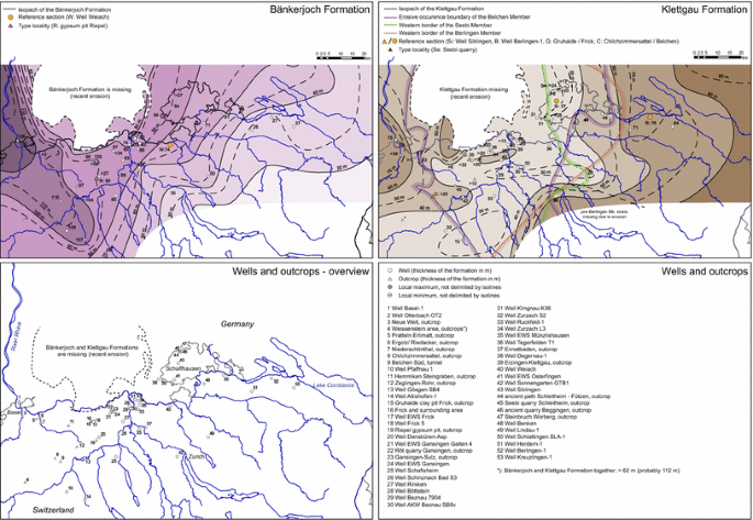
Isopach maps for the Bänkerjoch Formation and for the Klettgau Formation in northern Switzerland. Wells and outcrops used as database are shown in the overview map and description at the bottom
- Chronostratigr. Age:
-
Late Ladinian to Early Carnian (DSK 2002, 2005; Kozur and Bachmann 2008).
- Description:
-
Evaporitic sequence deposited in a marine to terrestrial salina or sabkha. The sequence can be subdivided in regressive meso- and microcycles and consists of sulphates, sulphate shale alternations, shale with nodular sulphate and shale. Fossiliferous dolomite and sandstone beds document marine ingressions and siliciclastic pulses from the Vindelician High. (Fig. 2).
- Lateral equivalents:
-
The Bänkerjoch Formation mostly corresponds to the Grabfeld Formation of southern Germany (excluding the sulphate-free upper part of the «Estherienschichten») and the uppermost part of Erfurt Formation (e.g. Etzold and Schweizer 2005, Geyer et al. 2011)
Towards the East, it correlates to the massive siliciclastic Benk Formation which may reach as far as the Lake Constance area according to the palaeogeographic reconstruction by Beutler and Nitsch (2005). Towards the South, the Bänkerjoch Formation wedges out.

3 Klettgau formation
3.1 Main characteristics
The Klettgau Formation encompasses around 30–75 m of playa sediments with fluvial and marine intercalations of Late Triassic age (Fig. 1). It includes what was formerly known as «Sandsteinkeuper» (e.g. Hofmann et al. 2000), «Mergelkeuper», (e.g. Jordan et al. 2008), or, more neutrally, «Oberer Mittelkeuper». Additionally, it also comprises the «Oberer Keuper» or «Rhät». In other words, the Klettgau Formation encompasses the whole interval between the Bänkerjoch Formation (this paper) and the Staffelegg Formation of Early Jurassic age (Reisdorf et al. 2011) (Fig. 2).
3.2 Type locality and reference sections
In northern Switzerland, there is no outcrop displaying the whole Klettgau Formation with all its members.
The best outcrop today is the Gruhalde clay pit in Frick (coord. 2642.925/1261.890–2643.075/1261.950), although the youngest part of the formation, now defined as Belchen Member, is missing here due to erosion during the Early Jurassic. Furthermore, the section includes only very thin interlayers of coarse Vindelician sand inputs, which are more dominant in northeastern Switzerland (now Berlingen and Seebi Members).
Regrettably, as the municipality name “Frick” was already occupied by another stratigraphic unit (Reisdorf et al. 2011) and local name “Gruhalde” was preferred to be given to member excellently outrcroping here, another type locality had to be found for the formation. After consideration of other still accessible outcrops, the Seebi quarry outcrop (coord. 2680.575/1291.800) near Schleitheim SH was chosen (Fig. 6) for four reasons: The quarry is a formally protected national geotope; it is situated in the Klettgau area, where the famous vineyards grow on Late Triassic marl and sandstone; the latter was renowned in masonry as «sandstone from Klettgau»; and the local name Klettgau was not used for a stratigraphic unit yet. From a stratigraphic point of view, it shows quite a good, though incomplete section including the coarse Vindelician sand inputs, the «Stubensandstein» (now Seebi Member).

Type section of the Klettgau Formation and of the Seebi Member at Seebi quarry in Schleitheim SH. Key see Fig. 4
Consequently, the Klettgau Formation relies, besides the type locality, mainly on the following reference sections:
-
Gruhalde clay pit in Frick AG (this paper, cf. Peters 1964; Gsell 1968).
-
Belchen/Chilchzimmersattel outcrop in Eptingen BL (this paper, cf. Erni 1910).
-
Siblingen well (Nagra 1992b).
3.3 Delimitation
The Klettgau Formation always overlays the Bänkerjoch Formation. The boundary is located at the top of a horizon consisting of one or more dolomite layers above the offset of Bänkerjoch Formation sulphate facies. For further discussion see Sect. 2.3.
The upper boundary of the Klettgau Formation is defined by a heterochronous (Late Early Hettangian to Early Sinemurian) transgression of the Staffelegg Formation over an erosional surface of variable reach in depth. In most areas in northern Switzerland, the upper boundary of the Klettgau Formation is clearly defined by the overlying of dark, often fossiliferous, marine marl and limestone over continental playa-type greyish to variegated dolomite marlstone. However, in northwestern Switzerland, where the sandy to marly estuarine to marine Belchen Member is overlain by sandy limestone of the Weissenstein Member (Staffelegg Formation, Reisdorf et al. 2011) delimitation becomes more sophisticated (see Sect. 4.6 Belchen Member).
3.4 Subdivision
The Klettgau Formation is subdivided, from bottom to top, in:
-
Ergolz Member.
-
Gansingen Member.
-
Berlingen Member.
-
Gruhalde Member.
-
Seebi Member.
-
Belchen Member.
The members will be described and formally defined in the following.
3.5 Genetic and palaeogeographic interpretation
The Klettgau Formation incorporates sediments deposited during a very long time span, around 26–30 million years according to DSK (2002). This time span is characterised by several changes in the environment including long periods of omission and erosion. The common pattern during this time is a broad depression connecting the Central European Basin with the Tethys Ocean, which reaches from Hessia to northern Switzerland and, via the so-called Burgundy gateway, further to southern France (Beutler and Nitsch 2005). Within this depression several marine ingressions, generally from southwest, are documented. Riverine input originates initially from Scandinavia. Later the direction of sediment transport changed to ENE-WSW. Northern Switzerland was then episodically covered by clastic delivery from the Vindelician High, which limited the depression in the southeast (Beutler and Nitsch 2005; Etzold and Schweizer 2005). For more details see discussion below where the different members are introduced.
3.6 Formal definition of the Klettgau formation
Names previously in use are given in Fig. 1.
- Origin of name:
-
Klettgau area, where the type locality is located.
- Type locality:
-
Abandoned quarry Seebi (Hofmann et al. 2000; Schalch 1916) in Schleitheim SH (coord. 2680.575/1291.800), formally protected as a geotope by cantonal law (Fig. 6).
- Type region:
-
Klettgau.
- Reference localities:
-
Gruhalde clay pit in Frick AG (coord. 2642.925/1261.890–2643.075/1261.950).
Siblingen well (coord. 2680.091/1286.694), drilling meter 48.78–84.49 (Nagra 1992b), fully cored and conserved in the Nagra core shack (Kernlager).
Berlingen well (coord. 2719.686/1280.194), drilling meter 2064.5–2140.0), partly cored (Berlingen Member type section fully cored and conserved in the SEAG core shack at Wermatswil).
Belchen/Chilchzimmersattel road cut close to Eptingen BL (coord. 2627.690/1246.165).
- Underlying strata:
-
Bänkerjoch Formation (this paper).
- Lower boundary:
-
Top of a horizon consisting of one or more dolomite layers above the offset of sulphate facies of Bänkerjoch Formation (see Sect. 2.3).
- Overlying strata:
-
Staffelegg Formation (Reisdorf et al. 2011).
- Upper boundary:
-
Transgression of Early Jurassic marine sediments (for details see discussion of Belchen Member and Gruhalde Member below).
- Subdivision (from bottom):
-
Ergolz Member, Gansingen Member, Berlingen Member, Seebi Member, Gruhalde Member, Belchen Member (see Sects. 4.1–4.6).
- Occurrence:
-
Northern Switzerland.
- Thickness:
-
30–60 m, locally up to 75 m (Fig. 5).
- Chronostratigr. Age:
-
Carnian to Rhaetian (DSK 2002, 2005; Kozur and Bachmann 2008).
- Description:
-
A quite heterogeneous succession dominated by variegated playa sediments, mostly silty shales and dolocretes, fine-grained to coarse-grained carbonatic or quarzitic fluvial sandstones in channels and overspill layers, estuarine to shallow-marine fossiliferous sandstone, marine shale and locally fossiliferous carbonates, now mostly dolomite, sulphate partially replaced by calcite, bonebeds at several levels (Fig. 2).
- Lateral Equivalents:
-
To the North, the Klettgau Formation corresponds (from bottom) to the uppermost parts of the Grabfeld Formation, the Stuttgart Formation, the Steigerwald Formation, the Hassberge Formation (disputed, see below), the Löwenstein Formation, the Trossingen Formation, and the Exter Formation (e.g. Etzold and Schweizer 2005; DSK 2005; Geyer et al. 2011). Towards the South, the Klettgau Formation corresponds to the Quarten Formation of the Helvetic domain («Quartenschiefer», Frey 1968).
4 Members of the Klettgau formation
4.1 Ergolz member
4.1.1 Main characteristics
The Ergolz Member replaces the former «Schilfsandstein» and «Untere Bunte Mergel» of Swiss stratigraphers (Fig. 1). As such, it mostly corresponds to the Stuttgart Formation and the (locally eroded) «Obere Bunte Estherienschichten» of the Grabfeld Formation of southern Germany. The latter comprise often silty (but not sandy) and in most cases sulphate-free variegate claystone to dolomitic marl and thin layers of dolomite and fine-grained sandstone. They are followed, cut or fully eroded by channels filled by fine to middle grained sandstone («Rinnenfazies», Etzold and Schweizer 2005) or silty to sandy variegate marl with dolocretes etc. («Überflutungsfazies» or, in the older literature, «Normalfazies», Etzold and Schweizer 2005). At some localities, «Rinnenfazies» dominates and only the uppermost part of the section is build up by «Überflutungsfazies». At other places, different levels of «Rinnenfazies» separated by «Überflutungsfazies» can be distinguished. And, finally, at some other places, «Rinnenfazies» can be fully absent or only be represented by thin horizons of fine sandstone.
4.1.2 Type locality
The natural outcrop along the Ergolz creek near Riedacher/Füllinsdorf BL was studied by Strübin (1901), Disler (1914) and, in 2000, by A. Etzold (pers. comm 2015). These records have been reviewed on-site in spring 2015 and spring 2016 (Jordan et al. 2016). The actual outcrop covers most of the overlying Gansingen Member and all of the Ergolz Member (Fig. 7).

Type section of the Ergolz Member at Ergolz/Riedacher in Füllinsdorf BL. Key see Fig. 4
The Ergolz section represents the common appearance of the Ergolz Member dominated by «Überflutungsfazies» (overbank deposits, see above) with distal echoes of «Rinnenfazies». The reddish fine sand of the «Rinnenfazies» (channels) proper are suitable for masonry and can be found in many abandoned or active quarries like Seebi (Schalch 1916) or Röt near Gansingen (Wildi 1976), respectively.
4.1.3 Delimitation
The lower boundary of the Ergolz Member is always identical with the lower boundary of the Klettgau Formation (see Sects. 2.3 and 3.3 for definition and discussion).
In most cases, the Ergolz Member is overlain by massive, at some places porous, marine limestone, which is nowadays dolomitised. It can easily be distinguished from dolocretes in the underlying Ergolz Member. Only where the overlying Gansingen Member has been almost fully eroded, its basal layer may be nodular (see discussion below).
Towards northeast, the upper boundary is successively defined by the onset of sulphate rocks, today partly altered into dolomite or limestone, i.e. the eastern facies of the Gansingen Member, or the onset of the coarse-grained sandstone of the Berlingen Member (see respective discussions below).
4.1.4 Genetic and palaeogeographic interpretation
In the lowest part, the equivalent to the «Obere Bunte Estherienschichten» of the German scheme corresponds to the end of a regressive cycle, where the evaporitic environment was replaced by a playa to fluvial environment.
The overlaying «Schilfsandstein» facies documents a large belt of meandering or even anastomosed rivers draining from Scandinavia into the Tethys near Lyon (Beutler and Nitsch 2005). An analysis of borehole and outcrop data confirms the concept of Wurster (1968) that the channel facies is concentrated along NNE–SSE trending lineaments (Fig. 8, key Fig. 9).


Key to Fig. 8
In southern Germany, two sedimentary cycles each beginning with abundant sandy channels and ending with nearly pure overbank facies are well documented (Etzold and Schweizer 2005). There is evidence that these two cycles can also be distinguished in northern Switzerland.
4.1.5 Formal definition of the Ergolz member
- Names previously in use:
-
«Schilfsandstein» and «Untere Bunte Mergel», further synonyms are given in Fig. 1.
- Origin of name:
-
Name of the creek along type section.
- Type locality:
-
Section along the Ergolz creek (coord. 2621.225/1263.525) near Riedacher/Füllinsdorf BL (Strübin 1901, Disler 1914; Jordan et al. 2016) (Fig. 7).
- Type region:
-
Basel area.
- Reference localities:
-
Weiach well (coord. 2676.745/1268.618), drilling meter 727.62–739.35 («Schilfsandstein sensu lato» of Matter et al. 1988 without basal «Dolomitmergelbank»; see Sect. 2.3), fully cored and conserved in the Nagra core shack (Kernlager).
- Underlying strata:
-
Bänkerjoch Formation.
- Lower boundary:
-
Top of a horizon consisting of one or more dolomite layers above the offset of sulphate facies of Bänkerjoch Formation (see Sect. 2.3). In rare cases, the «Rinnenfazies» channels have eroded at a level below the dolomite horizon. In this case, the lower boundary is defined by the onset of fluvial sand facies.
- Overlying strata:
-
Gansingen Member or Berlingen Member.
- Upper boundary:
-
In western and central northern Switzerland: Sharp contact from variegated dolomitic marl with dolocrete to initially marine limestone now being fully dolomitised (dolomite facies of Gansingen Member). In Schaffhausen area: Sharp contact to sulphates, locally being replaced by dolomite or calcite (evaporitic facies of Gansingen Member, see below). In Lake Constance area: sharp onset of Berlingen Member sand facies.
- Subdivision:
-
No formal subdivision yet.
- Occurrence:
-
Northeastern Switzerland.
- Thickness:
-
6–23 m.
- Chronostratigr. Age:
- Description:
-
Variegated playa type and fluvial silty to sandy overbank sediments with dolocretes, fluvial channels filled with reddish fine-grained sandstone (Fig. 2).
- Lateral Equivalents:
-
To the North: Stuttgart Formation and uppermost parts of the Grabfeld Formation (Etzold and Schweizer 2005; Geyer et al. 2011). To the East: marginal facies adjacent to the Vindelician High (Beutler and Nitsch 2005). To the South: «Equisetenschiefer» of the Helvetic Quarten Formation (Frey 1968).
4.2 Gansingen member
4.2.1 Main characteristics
The Gansingen Member corresponds to the Beaumont Horizon of the Steigerwald Formation in southern Germany. Originally, the fossiliferous «Dolomit von Gansingen» was described as a local curiosity by von Alberti (1864). In the mid-twentieth century, the term «Gansingen Dolomit» became more and more popular among Swiss geologists, first as an equivalent to the basal «Hauptsteinmergel» then to the whole Beaumont Horizon. For Swiss stratigraphers the «Gansingen Dolomit» was a succession rich in dolomite forming small cliffs and ridges within the surrounding marlstones (e.g. Müller et al. 1984). This concept was consequently applied to the core recordings of the Nagra deep drilling program (e.g. Matter et al. 1988; Nagra 1992a, b, 2001) and is now adopted for the definition of the Gansingen Member.
Towards northeast the marine late diagenetic dolomite facies (initially limestone) is successively replaced by an evaporitic facies. The primary calcium sulphate is partly replaced by dolomite or even calcite as, for instance, in the Seebi section (Jordan et al. 2016). According to the Nagra borehole records (e.g. Matter et al. 1988; Nagra 1992a, b, 2001) this facies is also integrated in the Gansingen Member. This agrees with Schalch (1916) who correlated the heterogeneous dolomite and limestone outcropping in the Klettgau and adjacent Wutach area as equivalents of the «Hauptsteinmergel». He also included the local «Duröhrlestein» variety, characterised by thin dark bituminous calcite (anthraconite or stinkstone) interlayers.
4.2.2 Type locality and reference sections
In order to maintain the name Gansingen, the Röt quarry near the village of Gansingen was chosen as type locality (Fig. 10). At that place, the Gansingen Member is very fossiliferous, in some layers even forming a coquina, as already mentioned by von Alberti (1864) and later described by Wildi (1976). However, only 0.4–1.0 m of the very basal layers of the Gansingen Member resisted here Late Triassic erosion (Jordan et al. 2016).

Type section of the Gansingen Member at Röt quarry in Gansingen AG. Key see Fig. 4
Thus, the 6 m thick undisturbed succession of the Gruhalde clay pit in Frick AG was determined as reference section of the Gansingen Member (Peters 1964; Gsell 1968; Jordan et al. 2016).
4.2.3 Delimitation
In most cases, the lower boundary of the Gansingen Member is sharp, independent if it is dolomitised limestone or calcitised/dolomitised sulphate rock resting on top of variegated dolomite marl. Only where Late Triassic erosion cut down to the basal layers, the latter may be disintegrated to nodules by subrosion processes. Generally, due to the compact texture (even when porous) and the local presence of ooids or bivalves, the basal bed of the Gansingen Member can easily be distinguished from dolocrete nodules or layers of the underlying Ergolz Member.
The upper boundary is in most cases more gradual. At the reference section in the Gruhalde clay pit in Frick, where the outcrop conditions are excellent and a bed by bed analysis of carbonate and clay mineral contents is available (Peters 1964), the upper boundary was defined where dolomite contents drop from 85 % to less than 50 % and desiccation features document the change from marine to playa environment. This quite sophisticated concept applies to boreholes and good outcrops. At other places the change in resistance to present-day erosion may help.
At some places, the upper boundary is erosive. At the type locality, the Gansingen Member is overlain by probably younger parts of the Gruhalde Member (see above). In the Klettgau area, the Gansingen Member is locally directly overlain by coarse sandstone of Seebi Member (Nagel 1990).
4.2.4 Genetic and palaeogeographic interpretation
The corresponding «Beaumont Horizon» in adjacent Upper Rhine Graben area is interpreted by Beutler and Nitsch (2005) to document a marine transgression connecting the Tethys and the Central European Basin. In the area discussed here, the low diverse and dwarfed fauna found in Frick and Gansingen outcrops (Wildi 1976) with several species of gastropods and bivalves is dominated by euryhaline genera as Bakevellia, Costatoria and Pseudocorbula, also characteristic for brachyhaline or hyposaline environments of the German Lettenkeuper (Erfurt Formation) (Hagdorn 2015). The occurence of Unionites in Gansingen suggest brackish environment. Stenohaline organisms as cephalopods or echinoderms are missing. The restricted marine facies was bordered, to the east, by salina or littoral sabkha-type evaporitic environments (also part of Seebi Member). The sabkha is again replaced eastwards by siliciclastic marginal facies adjacent to the Vindelician High (Berlingen Member). In a regressive cycle, the marine to lagoonal environment was successively replaced by a playa environment (Fig. 8).
4.2.5 Formal definition of the Gansingen member
- Names previously in use:
-
«Gansinger Dolomit» (sensu lato), further synonyms are given in Fig. 1.
- Origin of name:
-
Name of the municipality where the type locality is situated.
- Type locality:
-
Röt quarry in Gansingen AG (coord. 2651.600/1266.775) (Wildi 1976; Jordan et al. 2016) (Fig. 10).
- Type region:
-
Fricktal.
- Reference locality:
-
Gruhalde clay pit in Frick AG (coord. 2642.000/1261.925).
- Underlying strata:
-
Ergolz Member.
- Lower boundary:
-
Sharp onset of marine, today completely dolomitised, limestone with ooids and molluscs; forming molds when dissolved, or evaporitic sulphate, now altered to dolomite or limestone in many cases, over variegated marl with dolocretes of terrestrial playa origin.
- Overlying strata:
-
Gruhalde Member, locally Seebi Member (see Sect. 4.2.3).
- Upper boundary:
-
Gradual drop in dolomite or calcite content, desiccation features, at some places erosive (see Sect. 4.2.3).
- Subdivision:
-
No formal subdivision yet.
- Occurrence:
-
Northeastern Switzerland.
- Thickness:
-
0–6 m.
- Chronostratigr. Age:
- Description:
-
In northwestern and central northern Switzerland, locally fossiliferous or oolitic, partly cavernous massive dolomite continuing upward to laminated (stromatolitic) dolomite with marly intercalations. Towards northeastern Switzerland lateral transition into sulphate rocks in most cases altered to dolomite or limestone.
- Lateral Equivalents:
-
To the North: Beaumont Horizon of the Steigerwald Formation (Etzold and Schweizer 2005; Geyer et al. 2011). To the East: Berlingen Member (this paper). To the South: Tödi Grenzdolomit of the Helvetic Quarten Formation (Frey 1968).
4.3 Berlingen member
4.3.1 Main characteristics
In the wells Berlingen and Herdern (both in Canton Thurgau), a coarse-grained sandstone with calcitic matrix is found at the level where the Gansingen Member is expected (sandy layers of «Bunte Mergel (mit Sandlagen)» by Büchi et al. 1965). The sandstone can clearly be distinguished from the fine-grained Ergolz Member sandstone. These layers are significantly older than the Seebi Member, to which they show some similarities. Bläsi (1995) correlated these layers with the «Kieselsandstein» of southern Germany (now Hassberge Formation, e.g. Etzold and Schweizer 2005).
4.3.2 Type locality and reference sections
The Berlingen Member is entirely restricted to subcrops in boreholes in far northeastern Switzerland. Consequently, the well Berlingen-1 (Büchi et al. 1965), where the succession is well developed and fully cored, was chosen as the type locality for this member (Fig. 11). The core section, now defined as Berlingen Member, goes from drilling meter 2120.8–2125.0. This is more than the interval outlined as «Kieselsandstein» by Bläsi (1995). The 4.2 m thick interval consists of two sandstone successions separated by a marl interlayer with dolomite nodules.

4.3.3 Genetic and palaeogeographic interpretation
The Berlingen Member is interpreted as a sandy marginal facies of the Vindelician High. From the genetic point of view it shows affinities to the Hassberge Formation of southern Germany (e.g. Etzold and Schweizer 2005), even though it is probably significantly older (Fig. 8).
4.3.4 Formal definition of the Berlingen member
- Names previously in use:
-
«Sandlagen», «Kieselsandstein» (see Fig. 1).
- Origin of name:
-
Name of the type locality.
- Type locality:
-
Berlingen-1 well (coord. 2719.686/1280.194), drilling metre 2120.8–2125.0 (Büchi et al. 1965). The member comprises the interval denoted as «Kieselsandstein» by Bläsi (1995) and, additionally, the overlaying sandstone interval (Fig. 11). The cores are conserved in the SEAG core shack at Wermatswil.
- Type region:
-
Lake Constance area.
- Underlying strata:
-
Ergolz Member.
- Lower boundary:
-
Onset of sandstone over variegated marl.
- Overlying strata:
-
Gruhalde Member.
- Upper boundary:
-
Reset of variegated marl over sandstone.
- Subdivision:
-
No formal subdivision yet.
- Occurrence:
-
Northeastern Switzerland.
- Thickness:
-
Up to 5 m.
- Chronostratigr. Age:
- Description:
-
Middle-grained to coarse-grained, poorly sorted sandstone with quartz, feldspar and rocky fragments of the surrounding members. The matrix contains quartz cement, sulphate or clay in alternation with layers of clayey sandstone and claystone with dolomite nodules (Fig. 2).
- Lateral Equivalents:
-
To the West and North: presumably Gansingen Member, a correlation with the significantly younger Hassberge Formation of southern Germany has been postulated by Bläsi (1995), but not yet proven. To the East and South: marginal facies of Vindelician High, possibly sandy layers within the Helvetic Quarten Formation.
4.4 Gruhalde member
4.4.1 Main characteristics
The Gruhalde Member encompasses all sediments between the Gansingen or Berlingen Members (below) and the Belchen Member or Staffelegg Formation (above). In northeastern Switzerland it is interrupted by the massive sandy interval of the Seebi Member.
The Gruhalde Member represents a very long time span, some 20 Myr according to the stratigraphic scheme for southern Germany (DSK 2002). This time includes several important palaeogeographic revolutions, such as the Old-Kimmerian discontinuity. In fact, it is a 3–20 m thick succession of predominantly variegated playa-type dolomitic marl. In traditional Swiss stratigraphy it was summarised as «Obere Bunte Mergel».
4.4.2 Type locality
In whole northern Switzerland, the Gruhalde clay pit in Frick AG gives actually the best insight in the succession of the Gruhalde Member. The section was originally described by Peters (1964), Gsell (1968), Frey (1969), Gygi and Rieber (1989), Meyer and Furrer (1995) and, in 2000, by A. Etzold (pers. comm. 2015). Reisdorf et al. (2011) revised the Jurassic part of the section. From April to October 2015, the Triassic part was recorded anew by Jordan et al., (2016) using the results by the authors cited above (Fig. 12).

Type section of the Gruhalde Member, at Gruhalde clay pit in Frick AG. Key see Fig. 4
The lower boundary of the Gruhalde Member has been defined at the base of the first desiccation horizon, which is marked by persistent, regularly spaced teepee-type structures in a thin bedded alternation of light dolomite and green dolomitic marl. The boundary is accompanied by a dramatic decrease in dolomite content (Peters 1964).
The first part of the type section is a 2.8 m thick succession of variegated, predominantly greenish-grey, dolomitic marl and dolomite, which show some affinities to the underlying Gansingen Member including the persistence of the strata in outcrop scale.
The second part (1.8 m thick) is dominated by bright to dark (brownish) red dolomitic marl. At various levels, paraconformities can be suspected: A. Etzold (pers. comm. 2015) correlates the clearly visible, 1.2 m thick layer of bright red marl with the «Rote Wand» marker horizon in the German Steigerwald Formation. Consequently, he places the Old-Kimmerian discontinuity above this layer. But without further dating, it is not possible to localise the discontinuity definitely. Equivalents of the Old-Kimmerian Discontinuity probably lie somewhere within the second part. For instance, another striking horizon witnessing probably an important time gap can be recognised below the bright red marl. Finally a dolomite horizon above this second part can be interpreted as a soil horizon documenting a third significant time gap. The horizontal stratification and persistence of most layers in outcrop dimension are again characteristic for this part of the Gruhalde Member.
The third part is about 5 m thick and is first variegated, then changing to light grey color with purple striation further up. It is characterised by non-persisting layers and abundant channel structures. The channel fills consist of silty marl to coarse-grained sandstone, with mainly quartz and subordinately dolomite intraclasts and extraclasts, feldspar and mica. The matrix is dolomitic. Quartz grains show pressure solution and syntaxial growth. The channels are cut into dolomitic marl, which represents overbank deposits affected by pedogenesis. The finding of many bones including articulated skeletons of the prosauropod dinosaur Plateosaurus engelhardti (e.g., Sanders 1992; Foelix et al. 2011; Hofmann and Sander 2014) points to a terrestrial playa environment traversed by some channels. This is supported by sedimentological evidence (e.g., Meyer and Wetzel 2015).
The upper, fourth part of the Gruhalde Member at the type locality starts with a 20 cm thick persistent marker horizon consisting of well sorted, fine-grained sandstone (predominantly quartz, feldspar, intraclasts, ooids and mica). It alternates laterally and vertically with oolitic lenses. The presence of miliolid foraminifers in the sandstone and oolite documents marine to brackish conditions.
The remaining 10 m of the upper part consist mainly of greyish to light purple marl where some channels, filled with dolomite and dolomitic marl, occur. In the basal levels of this upper part Plateosaurus remains were also found, while in the uppermost part fragmentary but articulated skeletons of prosauropod and a fully articulated theropod dinosaur have been excavated (e.g. Meyer and Thüring 2003; Foelix et al. 2011).
A. Etzold (pers. comm. 2015) suggests to correlate the lower two parts of the Gruhalde Member in Frick with the «Rote Wand» of the Steigerwald Formation. The middle (third) part can be correlated, due to the presence of coarse-grained sand, with the German Löwenstein Formation (previously «Stubensandstein»). The presence of Plateosaurus remains points to a Late Norian age (C.A. Meyer, pers. comm. 2015) and, thus, to the upper part of Löwenstein Formation (Etzold and Schweizer 2005; Geyer et al. 2011). The uppermost part of the section may correlate with the German Trossingen Formation (although a marine ingression is not reported from there, Geyer et al. 2011). It is overlain by a thin layer of coarse sandstone containing a marine fauna with Waehneroceras sp. of Late Early Hettangian age (Meyer and Furrer 1995, Reisdorf et al. 2011). It marks the base of the Early Jurassic Staffelegg Formation (Reisdorf et al. 2011).
4.4.3 Delimitation
At many places, the lower boundary of the Gruhalde Member is defined by an erosional surface (see Sect. 4.2.2 and 4.2.3). In complete sections, the lower boundary is gradual given by the decrease in dolomite content (Sect. 4.2.3). In both cases, it is manifested in the morphologic change from the crest-forming Gansingen Member to the receding terrace or depression-forming Gruhalde Member.
In the area, where the Berlingen Member occurs, the lower boundary of the Gruhalde Member is defined by the offset of the coarse-grained sandstone. This delimitation is still somewhat vague in the Herdern well (Büchi et al. 1965), at the western limit of the Berlingen Member. It becomes more obvious towards east (e.g. in the Berlingen well, Büchi et al. 1965).
The recurrence of the Gruhalde Member in the area where the Seebi Member occurs is marked by the offset of the coarse-grained sand facies or sandy dolomite facies. The latter is present above the pure sand facies (see Sect. 4.5 for further discussion).
The upper boundary of the Gruhalde Member is defined by the transgression of the estuarine to marine Belchen Member or fully marine Staffelegg Formation, generally separated by a sharp erosional contact.
4.4.4 Subdivision
Based on scarce outcrop and borehole data, no satisfactory subdivision for the Gruhalde Member could be defined. In some good outcrops like at the type locality a detailed stratigraphy and correlation with the German scheme is definitely possible (see Sect. 4.4.3). Other outcrop and borehole evidence show that at many places variable small and in some cases significant parts of the succession are missing mainly due to erosion during the Late Triassic. This makes the identification of strata very sophisticated particularly in bad and incomplete outcrops. The Gruhalde Member therefore encompasses all strata formerly called «Bunte Mergel», «Obere Bunte Mergel», and «Knollenmergel».
4.4.5 Genetic and palaeogeographic interpretation
With a glimpse to the more complete succession in the adjacent southern Germany the history of the Gruhalde Member can be synoptically summarised as follows:
The marine episode documented in the Gansingen Member is followed by a coastal playa. Coarse-grained detrital input is restricted to northeastern Switzerland. Evidences at the Seebi quarry suggest that it is linked with erosion affecting parts of the Gansingen Member. Possibly, sedimentation continued in what is called Hassberge and Mainhart Formations in southern Germany (e.g. Etzold and Schweizer 2005) (Fig. 8).
Following the Old-Kimmerian orogenic movements, erosion cut at least down to the «Rote Wand», but at some places even the basal layers of the Gansingen Member were affected. The fluvial coarse-grained siliciclastics of the Seebi Member are well documented in northeastern Switzerland and extended probably into central northern Switzerland, but were later mostly eroded. In northeastern Switzerland the sandy facies developed to a possibly coastal sabkha type environment, where sandstone and marls were dolomitised. At the same time, a playa developed in northwestern Switzerland, slowly prograding towards east, where rivers carved channels into the muddy plains. The playa was drowned later, resulting in a short episode of marine or brackish sediments, but at least in the Frick area, playa sedimentation continued, accentuated by ephemeral channel incisions.
At some places erosion eliminated most of the previously deposited sediments before the deposition of the Belchen Member. Only few metres of the oldest well-layered variegated strata were left over, like, for instance, at the type locality of the Belchen Member (see Sect. 4.6.2).
4.4.6 Formal definition of the Gruhalde member
- Names previously in use:
-
«Obere Bunte Mergel», «Knollenmergel», further synonyms are given in Fig. 1.
- Origin of name:
-
Name of the type locality.
- Type locality:
-
Gruhalde clay pit (coord. 2642.925/1261.890–2643.075/1261.950) in Frick AG (Peters 1964; Gsell 1968; Gygi and Rieber 1989; Meyer and Furrer 1995; Reisdorf et al. 2011; Jordan et al. 2016) (Fig. 12).
- Type region:
-
Fricktal.
- Reference localities:
-
None.
- Underlying strata:
-
Gansingen Member or Berlingen Member.
- Lower boundary:
-
Mostly erosional, in rare complete sections the transition is gradual and the lower boundary is defined where the underlying compact dolomite succession ends and the clay content increases.
- Overlying strata:
-
Belchen Member (this paper) or Staffelegg Formation (Reisdorf et al. 2011).
- Upper boundary:
-
Where the Belchen Member is absent: transition of marine Jurassic sediments (claystone, marl, limestone, sandy limestone, sandstone) over greyish or variegated dolomitic marl.
- Where the Belchen Member is present:
-
Onset of sandstone, sometime with bonebeds or thin claystone.
- Intercalated strata:
-
Seebi Member.
- Boundaries:
-
Lower boundary: onset of coarse grain sandstone or, at some places, sandy dolomite, over variegated marl.
- Upper boundary:
-
Onset of variegated marl over sandy dolomite or, at some places, coarse sandstone.
- Subdivision:
-
No formal subdivision yet.
- Occurrence:
-
Northern Switzerland.
- Thickness:
-
3–20 m.
- Chronostratigr. Age:
-
Carnian to Rhaetian (?) (DSK 2002, 2005; Kozur and Bachmann 2008).
- Description:
-
Heterogeneous succession of variegated to greyish dolomitic marl with dolomite interlayers, mostly dolocrete, but also oolitic shallow marine dolomites, and intercalations of coarse sand, in most cases sandy dolomite to dolomitic sandstone. Widespread, often channel-type erosion affected the succession (Fig. 2).
- Lateral Equivalents:
-
To the North: Steigerwald Formation, Löwenstein Formation, Trossingen Formation (e.g. Etzold and Schweizer 2005; Geyer et al. 2011). To the east: Partly Seebi Member (this paper). To the south: Upper part of the Helvetic Quarten Formation above «Tödi Grenzdolomit»: «Untere Schiefer», «Grobdetritische Lagen», «Obere Schiefer (Quartenschiefer s.str.)» (Frey 1968).
4.5 Seebi member
4.5.1 Main characteristics
The Seebi Member corresponds to former «Stubensandstein». It consists of middle-grained to coarse-grained sandstones or conglomerates and the overlying sandy dolomite as found in the Schaffhausen area.
4.5.2 Type locality and reference sections
The abandoned Seebi quarry (coord. 2680.575/1291.800) near Schleitheim SH (also type locality for the Klettgau Formation) shows in its higher level a representative, but incomplete section of the Seebi Member. This section was already described by Schalch (1916) and Hofmann et al. (2000) and was newly recorded in May 2016 by Jordan et al., (2016) (Fig. 6).
The 5.2 m thick section comprises all three characteristic lithotypes of the Seebi Member: coarse grained sandstone to conglomerate, sometimes cross-bedded, forming 5–15 cm thick partly channelised beds; silty to sandy dolomitic mudstone; and dolomite marl. The section ends with a conglomerate bed with no overlaying strata visible.
The reference section (drilling meter 709.12–720.60) of the Benken well (coord. 2690.990/1277.843) shows the Seebi Member in a more distal marly facies («Stubensandstein» in Nagra 2001): It starts with a 4 m thick alternation of coarse-grained sandstones and conglomerates, sandy marl and sandy dolomites. The matrix of the sandstones is calcitic in the lower part and dolomitic in the upper part. It is followed by an approximately 1.9 m thick sandy dolomite succession and a succession of 5.4 m crumbly and cavernous brownish caliche-type dolomite nodules in a dolomitic to clayey matrix. At some levels oncoids and chert in form of nodules and joint fills are found.
Sandy dolomites in the upper part of the Seebi Member are also reported in the Schlattingen well (Albert et al. 2012) and in outcrops in the Klettgau area (Hofmann et al. 2000). In the Siblingen well (Nagra 1992b) the Seebi Member is represented by sandy dolomites only. In the Herdern and Berlingen wells (Büchi et al. 1965) the Seebi Member is developed in a purely sandy facies.
4.5.3 Genetic and palaeogeographic interpretation
Following the Old-Kimmerian orogenic movements, the Seebi Member represents a widespread progradation of fluvial facies from the East, i.e. from the Vindelician High. It was successively replaced by a playa to sabkha environment. Sulphcretes formed or original gypsum deposits were altered to dolomite (Fig. 8).
4.5.4 Formal definition of the Seebi member
- Names previously in use:
-
«Stubensandstein», further synonyms are given in Fig. 1.
- Origin of name:
-
Name of the type locality.
- Type locality:
-
Abandoned Seebi quarry (coord. 2680.575/1291.800) in Schleitheim SH (Schalch 1916; Hofmann et al. 2000; Jordan et al. 2016) (Fig. 6).
- Type region:
-
Klettgau area.
- Reference localities:
-
Benken well (coord. 2690.990/1277.843), drilling metre 709.12–720.60 («Stubensandstein» in Nagra 2001), fully cored and conserved in the Nagra core shack (Kernlager).
- Underlying strata:
-
Gruhalde Member, at rare places Gansingen Member (Nagel 1990).
- Lower boundary:
-
Onset of coarse-grained sandstone or conglomerate, in some cases sandy dolomite over variegated marl, in most cases above an erosional discontinuity.
- Overlying strata:
-
Gruhalde Member.
- Upper boundary:
-
Reset of variegated marl over sandstone or sandy dolomite.
- Subdivision:
-
No formal subdivision yet.
- Occurrence:
-
Northeastern Switzerland.
- Thickness:
-
1–10 m (correlated coarse sandstone or sandy dolomite occurrences with a thickness less than 1 m are taken as part of the Gruhalde Member).
- Chronostratigr. Age:
- Description:
-
Poorly sorted sandstones and conglomerates with predominantly polycrystalline quartz grains of volcanic, metamorphic or mylonitic origin, dolomite and clay pebbles, feldspar and, in most cases, calcitic matrix; dolomitic sandstones; and crumbly sandy dolomitised sulphcretes (Fig. 2).
- Lateral Equivalents:
-
To the North and Northeast: middle part of the Löwenstein Formation of southern Germany (e.g. Etzold and Schweizer 2005; Geyer et al. 2011). To the South: coarse grained detritc layers («Grobdetritische Schichten», Frey 1968) of the Helvetic Quarten Formation.
4.6 Belchen member
4.6.1 Main characteristics
There was much confusion with the term «Rhät» or «Oberer Keuper» when it was used as a lithostratigraphic unit. Traditionally it included «Rhätsandstein» and «Rhätmergel». For most authors, the term «Rhätsandstein» is restricted to a light grey to light green middle- to coarse-grained (mostly) carbonate-free sandstone that becomes white and disintegrates to glistening sand when weathered. There is more confusion about the term «Rhätmergel». The most widespread description is dark marl overlaying or replacing «Rhätsandstein» laterally. Some authors like Achilles and Schlatter (1986) denied to address some specific occurrences as «Rhät», because their fossil record proved that they were not of Rhaetian but Norian age. However the German stratigraphic table (DSK 2002) dates the «Postera Sandstein» of the lower Exter Formation as Late Norian, while overlying «Contorta-Schichten» and «Triletes-Schichten» are of Rhaetian age.
The purely lithostratigraphic definition of the Belchen Member aims to bring such discussions to an end. The compilation of Erni (1910) and a detailed examination of the recent borehole findings show that the Belchen Member starts in almost all cases with a sandstone deposited above a more or less prominent erosion surface. Only in a few cases thin dark shale layers are reported at the base. In almost all cases the sandstone contains little to no carbonate and shows the typical pressure solution and syntaxial growth of quartz grains. The sandstone is followed by dark marl, which may include sand or silt layers similar to the basal sandy facies. Erosion during the latest Triassic or earliest Jurassic eliminated the Belchen Member in central northern Switzerland.
4.6.2 Type locality
Close to Erni’s key section («Rhätprofil bei P. 1015 nördlich Bölchen (=Belchen)»; Erni 1910), a new complete section has been excavated along a forest road near Chilchzimmersattel BL (Jordan et al. 2016) (Fig. 13). The section is overturned due to tectonic folding. There is some jointing with small offset, but correlation across these discontinuities is easy.

Type section of the Belchen Member at Belchen/Chilchzimmersattel in Eptingen BL. Key see Fig. 4
The section starts within the Ergolz Member and includes also about 2–3 m of the Gansingen Member followed by 3 m of variegated marlstone representing the Gruhalde Member. The local facies corresponds best to the lower part of the Gruhalde type section. It is suggested that the moderate thickness of the member results from erosion prior to the deposition of the Belchen Member.
The Belchen Member begins with a 2.5 m thick alternation of 5–20 cm thick greenish sandstone layers alternating with thin dark shale interlayers. At the bottom carbonised horizons with plant and bone remains as well as some marine bivalve are found. Bioturbation is common. The sandstone layers consist mostly of well-sorted mid-sized quartz grains with pressure solution and syntaxial overgrowth rims. There is little feldspar and no mica (at other sites, for instance in the Adler area, mica is abundant in corresponding layers, Looser 2015). Asteriacites lumbricalis (von Schlotheim, 1820) resting traces (Cubichnia) of Ophiuroidea (brittle stars) and bivalves indicate a shallow marine environment. When weathered, the sandstone becomes white and disintegrates to glistening sand.
The sandy succession is followed by 1.5–1.8 m of dark silty dolomitic marl with lenses and dwelling structures filled by reddish sandstone to siltstone.
The sequence is overlain by an 8–15 cm thick sandy limestone bed full of disintegrated shells (deposited convex up) of various marine bivalves (Protocardia rhaetica Merian, 1953, Palaeocardita sp. Modiolus sp.). Further findings include inarticulate brachiopods (Discina sp.), reptile bones, scales and teeth of bony fish (e.g. Sargodon tomicus Plieninger, 1847) and shark teeth (Hybodus cloacinus Quenstedt, 1858, Lissodus minimus Agassiz, 1839; det. R. Kindlimann). This layer, here interpreted as a tempestite, is probably identical with the bonebed already mentioned by Merian (1857) «auf der Weide oberhalb des Kilchzimmers» (cited following Erni (1910), i.e. on the southwestern side of Chilchzimmersattel). Mühlberg (1893) (cited in Erni 1910) reported a specimen of Rhaetavicula contorta (Portlock, 1843) from this bed, a finding that is neither confirmed by Erni (1910) nor by the recent record.
The supposed tempestite is overlain by some 20 cm of black shale to grey marl, very similar to the marl found below.
The onset of the overlying Staffelegg Formation is marked by a sharp contact followed by a 10–15 cm thick slightly nodular limestone, rich in fossils including Gryphaea arcuata Lamarck, 1801, and Cardinia sp. In an overlying more massive limestone, separated by a marly interlayer of 15–20 cm thickness, Arnioceras sp. and Paracoroniceras sp. were found, documenting the Arnioceras semicostatum Zone of Sinemurian age. Thus, the Belchen Member of the Klettgau Formation is followed directly by the Beggingen Member of the Staffelegg Formation, and the Schambelen Member is missing here.
The type locality of the Belchen Member includes both lithologies, the gritty weathering sandstone and the dark marl, typical for what Erni (1910) called «Rhät». Looser (2015) correlates a borehole sequence «A» from the Adler area, south of Pratteln BL, where the Belchen Member is 6 m thick, with the type section. Based on carbon isotope stratigraphy, he concludes that the Belchen Member at the Chilchzimmersattel section only covers the earlier part of the time span documented in the Adler «A» section. Based on stable carbon isotope geochemistry, the Belchen Member at the type section and in the Adler area was deposited in the Late Rhaetian (Looser 2015). A preliminary palynostratigraphic analysis proves a middle Rhaetian age (GTr 18 and GTr 19, sensu Heunisch, 1999); the uppermost zone of the Rhaetian, GTr 20, is missing (pers. communication E. Schneebeli-Hermann, 19.02.2016).
This also applies to the Herdern-1 and Berlingen-1 wells, where 1.5 and 15.0 m, respectively, fine- to middle-grained, well-sorted greyish sandstone is reported, which is very similar to the sandstone of the basal Belchen Member at the Chilchzimmersattel section.
4.6.3 Delimitation
The lower boundary of the Belchen Member is erosive and starts in almost all cases with the typical light grey to light green quarzitic sandstone. At some places, the basal layer is developed as bonebed, very rarely as thin dark claystone layer.
The upper boundary is defined by the transgression of the marine Staffelegg Formation (Reisdorf et al. 2011). The delimitation of the Belchen Member is clear where sandstone is overlain by marl or limestone of the Schambelen Member or the Beggingen Member (Reisdorf et al. 2011), respectively. Otherwise the boundary can be drawn by fossil records. Ammonites, bivalves (Gryphaea, Cardinia) and crinoids prove Early Jurassic, while bonebeds and other bivalves (Protocardia, Palaeocardita, Rhaetavicula) are typical for the Late Triassic.
Delimitation becomes more difficult where the sandy limestone of the Weissenstein Member overlays directly the sandstone of the Belchen Member and index fossils are missing. In this case, quartz grain or carbonate analysis can be applied: the typical angular grains are restricted to the Belchen Member, which is generally poor in calcite. In the far northeastern Switzerland (Lake Constance area) delimitation becomes even more complicated as the Early Hettangian calcitic sandstone, not yet formally defined as a member of the Staffelegg Formation (Kiefer et al. 2015), overlays slightly calcitic sandstone of the Belchen Member. Kiefer et al. (2015) suggested as criteria for delimitation a significant increase in calcite matrix and the presence of crinoids, which are not known from the Belchen Member. A direct superposition of the shales of the Schambelen Member over the shales of the Belchen Member has not yet been reported.
4.6.4 Genetic and palaeogeographic interpretation
The lower part of the Belchen Member documents a brackish estuarine to marine environment, where open sea was located to the West, and is interpreted as a seaway connecting the Tethys with the marine Germanic Basin (Beutler and Nitsch 2005). With time the estuarine facies became progressively restricted towards east. It was replaced increasingly by shallow marine sandstones and finally by silstone and marl. This succession was later cut by regional erosion of Late Triassic or Early Jurassic age, which cut deepest in central northern Switzerland (Aare Massif–Black Forest High, e.g. Trümpy 1980) (Fig. 8).
4.6.5 Formal definition of the Belchen member
- Names previously in use:
-
«Rhät», further synonyms are given in Fig. 1.
- Origin of the name:
-
Belchen area where the type locality is situated.
- Type locality:
-
Road cut section (coord. 2627.690/1246.165) below Chilchzimmersattel road pass 2.5 km SW Eptingen BL (Jordan et al. 2016) close to the original section of Erni (1910) (Fig. 13).
- Type region:
-
Belchen–Hauenstein area.
- Reference localities:
-
None.
- Underlying strata:
-
Gruhalde Member.
- Lower boundary:
-
Onset of sandstone succession, at some localities with bonebed, or more rarely, a thin dark shale layer at the base, above variegated or greenish-grey marl.
- Overlying strata:
-
Staffelegg Formation (Reisdorf et al. 2011).
- Upper boundary:
-
Transgression of marine sediments with characteristic fossils of Early Jurassic age (e.g., ammonites, crinoids, bivalves such as Gryphaea sp.) over quartzitic sandstone and dark marl and claystone (see discussion above).
- Subdivision:
-
No formal subdivision yet.
- Occurrence:
-
Northern Switzerland.
- Thickness:
-
0–6 m in northwestern Switzerland (Erni 1910), up to 15 m in the Lake Constance area (Büchi et al. 1965; Kiefer et al. 2015).
- Chronostratigr. Age:
-
(?) Norian to (at least middle) Rhaetian (Achilles and Schlatter 1986; DSK 2002, 2005; Kozur and Bachmann 2008; Looser 2015).
- Description:
-
Predominantly middle-grained, well-sorted, mostly carbonate-free quartzitic sandstone with thin shale interlayers overlain by dark marl and claystone with sandy interlayers and burrows, bonebeds (Fig. 2).
- Lateral Equivalents:
-
To the North and Northwest, the Belchen Member corresponds to the Exter Formation (e.g. Etzold and Schweizer (2005); Geyer et al. 2011). Towards the South it is missing or it is a not distinguishable part of the Vindelician marginal facies documented in the Helvetic Quarten Formation.
References
Achilles, H., & Schlatter, R. (1986). Palynostratigraphische Untersuchungen im ‘Rhät-Bonebed’ von Hallau (Kt. Schaffhausen) mit einem Beitrag zur Ammonitenfauna im basalen Lias. Eclogae Geologicae Helvetiae, 9, 149–179.
Albert, W., Bläsi, H.R., Hertrich, M., Weber, H.P. (2012). Erdwärmesondenbohrungen Löhningen (SH), Osterfingen (SH), Hemmental (SH), Beringen (SH), Schönenwerd (SO), Wölflinswil (AG): Geologische Aufnahme und bohrlochgeophysikalische Messungen (Rohdaten). Nagra Arbeitsber. NAB 12–24 (p. 29). Nagra, Wettingen.
Alberti, F. V. (1864). Übersicht über die Trias mit Berücksichtigung ihres Vorkommens in den Alpen (p. 353). Stuttgart: Verlag der J. G. Cottaschen Buchhandlung.
Beutler, G. (2005). Lithostratigraphie. Deutsche Stratigraphische Kommission, 2005: Stratigraphie von Deutschland IV: Keuper.—Cour. Forsch.-Inst. Senckenberg, 253, 65–84.
Beutler, G., & Nitsch, E. (2005). Paläogeographischer Überblick. Deutsche Stratigraphische Kommission, 2005: Stratigraphie von Deutschland IV: Keuper.—Cour. Forsch.-Inst. Senckenberg, 253, 15–30.
Bitterli-Brunner, P., Fischer, H. (1988). Blatt 1067 Arlesheim. Geologischer Atlas der Schweiz 1:25,000, Erläuterungen 80 (p. 66). Bern: Landeshydrologie und -geologie.
Bitterli-Dreher, P., Graf, H.R., Naef, H., Diebold, P., Matousek, F., Burger, H., Pauli-Gabi, T. (2007). Blatt 1070 Baden. Geol. Atlas der Schweiz 1:25,000, Erläuterungen 120 (p. 152). Bundesamt für Landestopografie swisstopo.
Bläsi, H.R. (1995). Fazies, Diagenese und wasserführende Systeme in den kalkigen und sandigen Sedimentkörpern von Schilfsandstein bis Dogger beta in den Bohrungen Lindau-1, Herdern-1, Berlingen-1, Kreuzlingen-1 und Meersburg-1, Teil 1: Fazies und Stratigraphie. Unpubl. Nagra Interner Ber. Nagra, Wettingen.
Büchi, U. P., Lemcke, K., Wiener, G., & Zimdars, J. (1965). Geologische Ergebnisse der Erdölexploration auf das Mesozoikum im Untergrund des schweizerischen Molassebeckens. Bulletin der Schweizerischen Vereinigung von Petroleum-Geologen und -Ingenieuren, 15, 7–38.
Deecke, W. (1916). Geologie von Baden—Erster Teil (p. 406). Berlin: Verlag von Gebrüder Borntraeger.
Diebold, P., Bitterli-Brunner, P., Naef, H. (2006). Blatt 1069/1049 Frick-Laufenburg. Geol. Atlas der Schweiz 1:25,000, Erläuterungen (p. 136). Bundesamt für Landestopografie swisstopo.
Disler, C. (1914). Stratigraphischer Führer durch die geologischen Formationen im Gebiet zwischen Aare (p. 96). Birs und Rhein: Basel, B. Wepf & Co., Verlag.
Dronkert, H., Bläsi, H.R., Matter, A. (1990). Facies and origin of triassic evaporites from the Nagra boreholes. Technischer Bericht, NTB 87-02 (vol. 80, pp. 397–413). Nagra, Wettingen.
DSK. (2002). Stratigraphische Tabelle von Deutschland 2002. Tafel 96 × 130 cm oder Falt-Tafel A4; Potsdam (GeoForschungsZentrum), Frankfurt a. M. (Forsch.-Inst. Senckenberg), 1 chart.
DSK. (2005). Deutsche Stratigraphische Kommission (Hrsg.): Stratigraphie von Deutschland IV—Keuper. Courier Forschungsinstitut Senckenberg 253, 296.
Erni, A. (1910). Das Rhät im schweizerischen Jura. Eclogae Geologicae Helvetiae, 11, 5–54.
Etzold, A., & Schweizer, V. (2005). Der Keuper in Baden-Württemberg. Deutsche Stratigraphische Kommission, 2005: Stratigraphie von Deutschland IV: Keuper.—Cour. Forsch.-Inst. Senckenberg, 253, 214–258.
Fischer, H. (1969). Einige Bemerkungen zur «Übersichtstabelle zur Geologie der weiteren Umgebung von Basel». Regio Basiliensis, 10, 234–238.
Foelix, R., Pabst, B., & Kindlimann, R. (2011). Die Saurier in Frick. Mitteilungen der aargauischen Naturforschenden Gesellschaft, 37, 59–75.
Frey, M. (1968). Quartenschiefer, Equisetenschiefer und germanischer Keuper: ein lithostratigraphischer Vergleich. Eclogae Geologicae Helvetiae, 61, 141–156.
Frey, M. (1969). Die Metamorphose des Keupers vom Tafeljura bis zum Lukmaniergebiet. Beiträge zur Geologischen Karte der Schweiz, Neue Folge, 137, 160.
Geyer, O.F., Gwinner, M.P. (1986). Geologie von Baden-Württemberg. 3. Aufl. E. Schweizerbart’sche Verlagsbuchhandlung (Nägele u. Obermiller), Stuttgart, p. 472.
Geyer, O.F., Nitsch, E., & Simon, T. (2011). Geologie von Baden-Württemberg. 5., völlig neu bearbeitete Auflage, Verlag Schweizerbart Stuttgart 2011, p. 627.
Gsell, F. (1968). Geologie des Falten- und Tafeljura zwischen Aare und Wittnau und Betrachtungen zur Tektonik des Ostjura zwischen dem Unteren Hauenstein im W und der Aare im E. Univ. Zürich Inaugural-Dissertation, p. 138.
Gygi, R. A., & Rieber, H. (1989). Der Aargauer Jura zwischen Laufenburg und Wildegg. Jahresberichte und Mitteilungen des Oberrheinischen Geologischen Vereins, 71, 177–188.
Hagdorn, H. (2015). Wirbellose des Lettenkeupers. In: H. Hagdorn, R. Schoch, G. Schweigert (Eds.), Der Lettenkeuper - ein Fenster in die Zeit vor den Dinosauriern (pp. 107–140). Paleaodiversity - Sonderband, Stuttgart, Ingelfingen.
Hauber, L. (1960). Geologie des Tafel- und Faltenjura zwischen Reigoldswil und Eptingen (Kanton Baselland). Kümmerly und Frey XIV: Komm. 71 p.
Heunisch, C. (1999). Die Bedeutung der Palynologie für die Biostratigraphie und Fazies in der Germanischen Trias. In N. Hauschke & V. Wilde (Eds.), Trias, Eine ganz andere Welt, Mitteleuropa im frühen Erdmittelalter (pp. 207–220). München: Pfeil.
Hofmann, R., & Sander, M. P. (2014). The first juvenile specimens of Plateosaurus engelhardti from Frick, Switzerland: isolated neural arches and their implications for developmental plasticity in a basal sauropodomorph. PeerJ, 2, e458. doi:10.7717/peerj.458.
Hofmann, F., Schlatter, R., & Weh, M. (2000). Erläuterungen zu Blatt 97: Beggingen (LK 1011) des Geologischen Atlas der Schweiz 1:25,000 (p. 113). Bern: Bundesamt für Wasser und Geologie.
Jordan, P. (2016). Reorganisation of the stratigraphy of the Triassic strata of Northern Switzerland. Swiss Journal of Geosciences,. doi:10.1007/s00015-016-0209-4.
Jordan, P., Pietsch, J., Bläsi, H.R., Deplazes, G. (2016). Definition und Unterteilung der Klettgau- und Bänkerjoch-Formation (vormals Oberer und Mittlerer Keuper) in der Nordschweiz. Nagra Arbeitsbericht (in preparation).
Jordan, P., Wetzel, A., Reisdorf, A.G. (2008). Jurassic. Swiss Jura Mountains. Mccann, T. (Ed.) The geology of Central Europe, vol. 2: Mesozoic and Cenozoic—Geol. Soc. (pp. 880–889) London.
Kiefer, L., Deplazes, G., Bläsi, H.R. (2015). Sedimentologie und Stratigraphie des Frühen Juras in der Nordschweiz: Staffelegg-Formation und sich nach Osten anschliessende Vorkommen. Nagra Arbeitsbericht, NAB 14–95, p. 104.
Kleiner, J. (2009). Die Paläoumwelt der Keuperschichten und der Lias-Doggerschichten zwischen Küttigen und Frick (Aargauer Jura). Master Thesis, Univ. Fribourg, p. 81.
Kozur, H., & Bachmann, G. H. (2008). Updated correlation of the Germanic Triassic with the Tethyan scale and assigned numeric ages. Berichte der Geologischen Bundesanstalt, Wien, 76, 53–58.
Looser, N. (2015). Environmental Changes at the Triassic-Jurassic boundary in northern Switzerland—Insights from stable carbon and nitrogen isotope geochemistry, sedimentology and palynology. Master Thesis, ETH Zürich, p. 55.
Matter, A., Peters, T., Bläsi, H.R., Meyer, J., Ischi, H., Meyer, C. (1988). Sondierbohrung Weiach. Geologie. Nagra Tech. Ber. NTB 86-01 (p. 183). Nagra, Wettingen.
Meier, I. (2011). Sulfur isotopes of Gipskeuper and Anhydritgruppe in Northern Switzerland. Master Thesis, ETH Zurich, p. 102.
Merian, P. (1857). Über das sogenannte Bonebed. Verhandlungen der Naturforschenden Gesellschaft Basel, 1, 581–586.
Meyer, C. A., & Furrer, H. (1995). Taphonomie und paläoökologische Rekonstruktionen: Beispiele aus dem Mesozoikum des Jura. Bericht über die Exkursion der Schweizerischen Paläontologischen Gesellschaft gemeinsam mit der Schweizerischen Geologischen Gesellschaft am 4. Oktober 1994. Eclogae Geologicae Helvetiae, 88, 711–720.
Meyer, C. A., & Thüring, S. (2003). Dinosaurs of Switzerland. C. R. Palevol, 2, 103–117.
Meyer, C.A., Wetzel, A. (2015). The Late Triassic bonebed of Niederschönthal (Norian, Knollenmergel, Füllinsdorf BL)—Amanz Gressly’s dinosaur locality revisited. SGM Meeting 2015, Basel, Abstract volume, p. 152.
Morard, A. et al. (2012). Lithostratigraphy of Switzerland: Options and challenges for a harmonisation. 10th Swiss Geoscience Meeting abstract volume, p.173.
Mühlberg, F. (1893). Bericht über die Exkursion der Schweiz. geologischen Gesellschaft in das Gebiet der Verwerfungen, Überschiebungen und Überschiebungsklippen im Basler- und Solothurner-Jura vom 7–10. September 1892. Eclogae Geologicae Helvetiae, 3, 413–521.
Mühlberg, F. (1908). Geologische Karte der Schweiz, Erläuterungen zur geologischen Karte der Umgebung von Aargau 1:25,000. Bern: A. Francke.
Mühlberg, F. (1915). Geologische Karte der Schweiz, Erläuterungen zur Geologischen Karte des Hauensteingebietes (Waldenburg-Olten) 1:25,000 (Spezialkarte Nr. 73). Bern: A. Francke.
Müller, W.H., Huber, M., Isler, A., Kleboth, P. (1984). Erläuterungen zur Geologischen Spezialkarte Nr. 121 der zentralen Nordschweiz 1:100,000 mit angrenzenden Gebieten von Baden-Württemberg. Baden: Nationale Genossenschaft für die Lagerung radioaktiver Abfälle (NAGRA) und Schweizerische Geologische Kommission, p. 234.
Nagel, R. (1990). Stratigraphie und Paläogeographie im höheren Mittelkeuper Südwestdeutschlands und angrenzender Gebiete. Arbeiten aus dem Institut für Geologie und Paläontologie der Universität Stuttgart, N.F. 85, 111–171.
Nagra (1992a). Sondierbohrung Schafisheim. Untersuchungsbericht. Nagra Tech. Ber. NTB 88-11 (p. 183). Nagra, Wettingen.
Nagra. (1992b). Sondierbohrung Siblingen. Untersuchungsbericht. Nagra Techn. Ber. NTB 90-34 (p. 130). Nagra, Wettingen.
Nagra. (2001). Sondierbohrung Benken. Untersuchungsbericht. Nagra Tech. Ber. NTB 00-01 (p. 290). Nagra, Wettingen.
Peters, Tj. (1964). Tonmineralogische Untersuchungen an einem Keuper-Lias-Profil im Schweizer Jura (Frick). Schweizerische Mineralogische und Petrographische Mitteilungen, 44, 1–30.
Peters, T.J., Matter, A., Bläsi, H.R., Gautschi, A. (1986). Sondierbohrung Böttstein. Geologie. Nagra Tech. Ber. NTB 85-02 (p. 190). Nagra, Wettingen.
Pietsch, J., Wetzel, A., & Jordan, P. (2016). A new lithostratigraphic scheme for Schinznach Formation (Upper Muschelkalk of Northern Switzerland). Swiss Journal of Geosciences,. doi:10.1007/s00015-016-0214-7.
Reisdorf, A. G., Wetzel, A., Schlatter, R., & Jordan, P. (2011). The Staffelegg formation: a new stratigraphic scheme for the Early Jurassic of northern Switzerland. Swiss Journal of Geosciences, 104, 97–146.
Remane, J., Adatte, T., Berger, J.-P., Burkhalter, R., Dall’Agnolo, S., Decrouez, D., et al. (2005). Richtlinien zur stratigraphischen Nomenklatur. Eclogae Geologicae Helvetiae, 98, 385–405.
Rick, B. (1990). Geotechnische und hydrochemische Folgen der Verwitterung sulfathaltiger Gesteine (Gipskeuper des Schweizer Jura) Diss. Naturwiss. ETH Zürich, Nr. 9257, p. 89.
Rügner, O. (2000). Tonmineral-Neubildungen und Paläosalinität im Unteren Muschelkalk des südlichen Germanischen Beckens (p. 196). Disseration. Univ., Heidelberg.
Sander, M. P. (1992). The norian Plateosaurus bonebeds of central Europe and their taphonomy. Palaeogeography, Palaeoclimatology, Palaeoecology, 93(3–4), 255–299.
Schalch, F. (1916). Geologische Spezialkarte des Grossherzogtums Baden. Erläuterungen zu Blatt Wiechs-Schaffhausen (Nr. 145). Heidelberg: Carl Winter’s Universitätsbuchhandlung.
Schindler, C. (1962). Gipsvorkommen zwischen Riepel und Staffelegg. Unpubl. Gutachten geotechnisches Büro Dr. A. von Moos für Jura-Cementfabrik Aarau-Wildegg.
Schmassmann, H. (1953). Das Keuper-Profil von Neue Welt. Tätigkeitsberichte der Naturforschenden Gesellschaft Baselland, 19, 1950–1952.
Strasky, S., Morard, A., Möri, A. (2016). Harmonising the lithostratigraphic nomenclature: towards a uniform geological dataset of Switzerland. Swiss Journal of Geosciences, 109. doi:10.1007/s00015-016-0221-8
Strübin, K. (1901). Neue Aufschlüsse in den Keuper-Liasschichten von Niederschönthal (Basler Tafeljura). Eclogae Geologicae Helvetiae, 7, 119–121.
Trümpy, R. (1980). Geology of Switzerland: An outline of the geology of Switzerland (p. 334). Basel: Schweizerische Geologische Kommission/Wepf.
Wildi, W. (1976). Die Molluskenfauna des Gansinger Dolomites (Trias, Karnian, Mittlerer Keuper) im aargauischen Tafeljura (Nordschweiz). Eclogae Geologicae Helvetiae, 69, 671–684.
Wurster, P. (1968). Paläogeographie der deutschen Trias und die paläogeographische Orientierung der Lettenkohle in Südwestdeutschland. Eclogae Geologicae Helvetiae, 61, 157–166.
Acknowledgments
This paper has benefited from valuable discussions, constructive reviews and useful suggestions from Peter Bitterli-Dreher, Reto Burkhalter, Andreas Etzold, Hans Hagdorn, Albert Matter, Martin Mazurek, Christian A. Meyer, Alain Morard, Edgar Nitsch, and Walter Wildi. Special thanks are also due to the members of the Swiss Committee for Stratigraphy, and, especially of the Eastern Jura Mountains sub group and its late president, Werner Heckendorn. The National Cooperative for the Disposal of Radioactive Waste/Nagra is thanked for financial support.
Author information
Authors and Affiliations
Corresponding author
Additional information
Editorial handling: W. Winkler and A. Morard.
Rights and permissions
About this article

Cite this article
Jordan, P., Pietsch, J.S., Bläsi, H. et al. The middle to late Triassic Bänkerjoch and Klettgau formations of northern Switzerland. Swiss J Geosci 109, 257–284 (2016). https://doi.org/10.1007/s00015-016-0218-3
Received:
Accepted:
Published:
Issue Date:
DOI: https://doi.org/10.1007/s00015-016-0218-3